Found a note on my truck from Grant Niceswanger, the BLM Ranger for the area: (How did he know to put it on mine, out of 15 vehicles?): "Sorry I missed you. Drop me a line sometime. I like to know who's using the area (for statistics and to let hard core off-roaders know they aren't the only ones). My area extends from Nev. line on east, San Bernardino Co on south, Death Valley on west. Great Day! Great to see so many people enjoying the area!" Grant left his P.O. Box in Pahrump, Nev. Sending him a copy of this writeup. This warm, friendly attitude of most BLM Rangers is in sharp contrast to the citation-happy mind-set of perhaps half the Park Service rangers this writer has encountered!
Changed plans: After the obligatory soak in Tecopa Hot Springs, We camped at Mud Bluffs (.7 mi E of Shoshone, left between the tamarisk trees.) instead of driving deep into Greenwater Valley to poise for a second tough day of Smith AND Brown. We even slept in until 6:30, off at 7:30 & drove to Gold Valley. Southern loop O.K. for all pickups with clearance, although one 2WD driver balked. North part of the Gold Valley loop was O.K. for all pickups. 20 hiked Smith via the standard route, something less than 2 hrs up, leisurely lunch, and 1.5 hr down. Most went for a quick dip at Tecopa again Sunday before driving home. 7 of us stayed over, had dinner at the Miners' Diner in Tecopa (O.K. & they let you bring in your own wine!) & enjoyed our second night's campfire, although it was cold & windy.
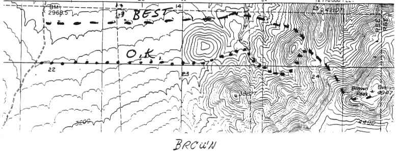
Monday, MLK Jr's birthday, 6 of us drove over Deadman Pass & hiked Brown. The current DPS Road & Peak Guide route for Brown is terrible. We drove about 1.7 mi N of Deadman Pass & parked at 3040' altitude, headed due E, to the south of the 3320+' hill, up the canyon to the ridge E of the 3800'+ hill & up to the summit. All 6 of us were on top 2:20 after leaving vehicles. Returning, we went to the saddle just E. of the 3800'+ hill & dropped down NW, then due west. This is probably the best route, up and down. Our time was 1:50 plus 25 mm lunch break. Total 4:10 + lunch. A third day at the hot spring, then a fair dinner at Carlos & Toto's in Barstow.
Brown: park 2.1 mi N of Deadman's Pass, 2960'3000' & hike due east to the 3720+' saddle E of 3800'+ hill, then follow ridge to summit: 2000' gain. 4 hrs r.t., 7 mi r.t.