24 signed in at Shoshone: Dale Van D, F. Camphausen, Tom Scott, Dave Petzold, Carolyn West, Karen Leonard, Scott Sullivan, Susan Feuerbach, Julie King, Jim Conley, Becky Heaton, Bill Stevens, Sue Wyman, Vic Henney, Ron Lanyi, Ron Grau, Evelyn Chadwell, John Jandrall, Anni Johansen, Vicky Hoover, Alan Canton, Wendy Ruess, Paul Backer, Dick Agnos. John McCully & dog left earlier & hiked privately. We drove into Twelvemile Spring & started hiking by 7:45.
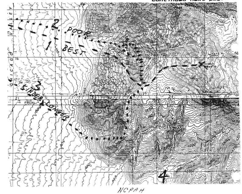
Oldtimer's Disease is setting in; leader forgot his smooth route of 5 years ago (#1 on map) and instead went up the deep gully just to the north (#2 on the map). We encountered a class 3 dry waterfall & tried to find an easier route, lost several hundred feet, paused to scout & Vic H. found a traverse back into the canyon that went. Eventually, 21 of us made the South summit of Nopah, lower on the old 15' topo, higher on the newer 7.5' topo, and most importantly, the one with the register! Lunch on the top & then Campy took us down the Kinder, Gentler, SW Ridge, (#3 on the map). Last 2 people wandered back after 6 P.M. & a 10.5 hr day, on what should have been an 8.5-9 hr peak. Note: One can drive south on a faint track from Twelvemile Spring, then east cross-country to the ooint labeled "4" on the map. We didn't for two reasons: