Route Description
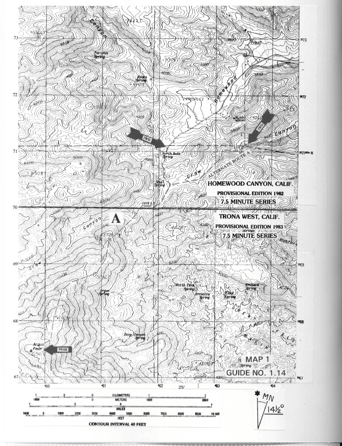
DRIVE/ROUTE A (HOMEWOOD CANYON): From the Inyo County Line sign just N of Trona, CA drive 6.4 m iles N on the paved Trona-Wildrose Road to the signed, paved Homewood Canyon Road. Turn left (W) here and drive 4.9 miles up Homewood Canyon to the end of pavement just W of the Ruth Mine. Continue straight (SW) on good dirt 0.75 miles to where the road forks in four directions at the base of a hill at 3800 feet elevation. Park.
CLIMB/ROUTE A (HOMEWOOD CANYON): See Map 1. From the vehicles take the poor dirt road that goes steeply up the hill, hiking 0.25 miles to a saddle. From here drop down the other side for 0.25 miles to the sand wash in Crow Canyon. Turn right (SW) and follow the wash 0.75 miles to the 4100 foot elevation level at the signed boundary of the Naval Weapons Center. Turn left (SW) here, climbing up a steep slope and gaining the ridge line which is followed to a saddle just W of point 5216. Follow the ridge from this saddle, skirting below and around the right (W) side of point 6163 to a broad saddle 0.35 miles NE of the peak. Head SW from here up a somewhat brushy ridge to the summit.
ROUND TRIP STATS/ROUTE A: 3000 feet elevation gain, 7.5 miles, 6 hours
DRIVE/ROUTE A ALTERNATE (CROW CANYON): From the Inyo County Line sign just N of Trona, CA drive 6.4 m iles N on the paved Trona-Wildrose Ro ad to the signed, paved Home wood Canyon Road. Turn left (W) here and drive 2.9 miles to the signed Crow Canyon Road. Turn left (S), following the m ain road 0.4 miles (be careful not to take any side forks into private property) to a T-junction. Turn left here and drive a progressively deteriorating dirt road SW for 1.1 miles into Crow Canyon, parking at the base of a steep hill at 3400 feet elevation. NOTE: The wash in Crow Canyon may be some what sandy, so 2WD's should be careful here.
CLIMB/ROUTE A ALTERNATE (CROW CANYON): See Map 1. Hike S for 50 yards to a sand wash and then generally SW up the wash for about 1.75 mile to the 4100 foot elevation level at the signed boundary of the Naval Weapons Center. Follow ROUTE A (HOMEWOOD CANYON) from here to the summit.
ROUND TRIP STATS/ROUTE A ALTERNATE (CROW CANYON): 3200 feet elevation gain, 8.5 miles, 7 hours
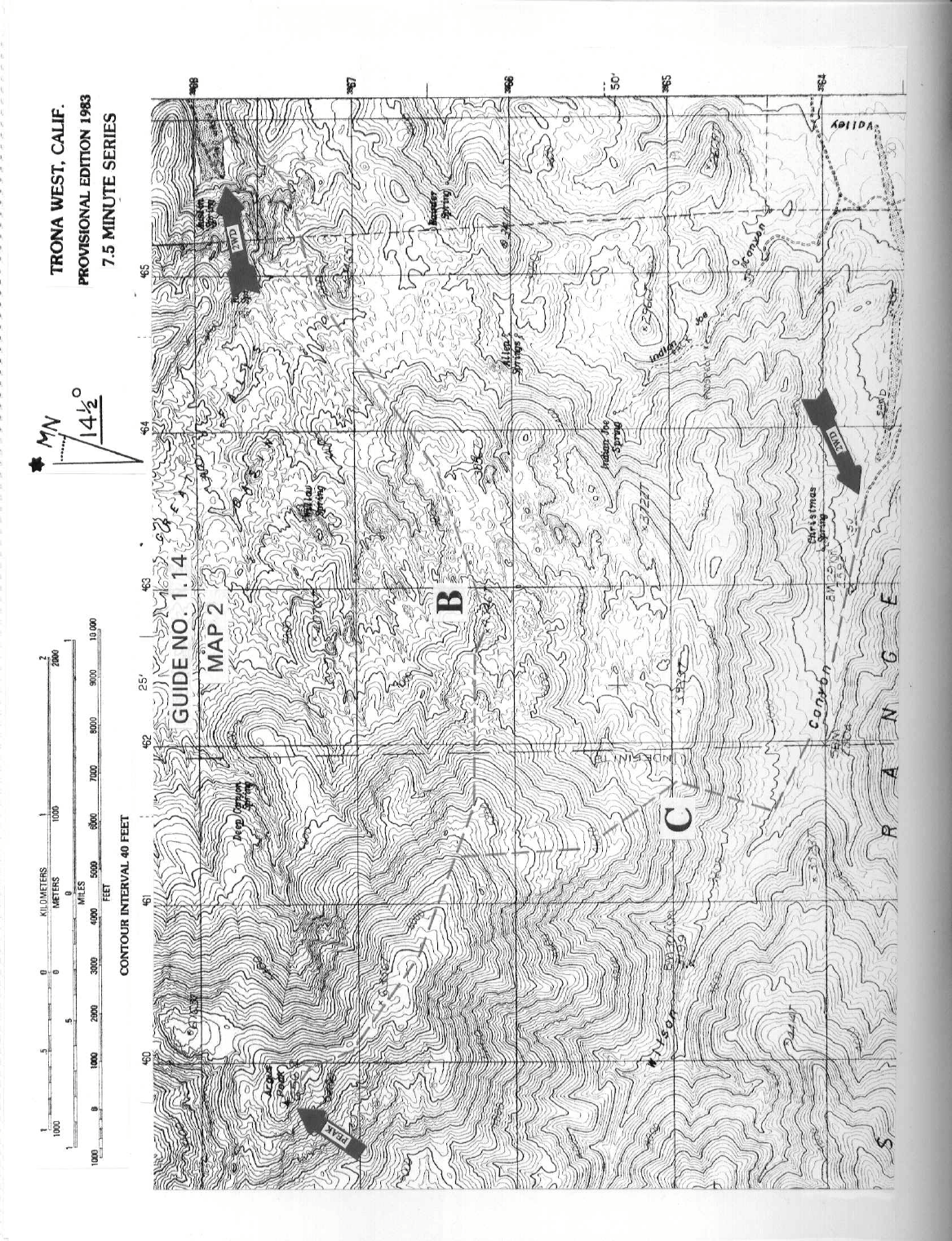
DRIVE/ROUTE B: This route describes the Great Falls Basin approach to Argus Peak. From the Inyo County Line sign just N of Trona, CA drive 2.7 miles N on the paved Trona-Wildrose Road to a dirt road turnoff heading left (NW) toward the mountain (This turnoff is 0.2 miles N of the signed Valley Wells Road). Turning left here, follow a sandy road approximately 3.2 miles to its end at the mouth of a rocky canyon. Park. NOTE: As you approach to within about 0.5 miles of this spring, look for a faint trail on the hillside to your left. This trail will be used to access the Great Falls Basin.
CLIMB/ROUTE B: See Map 2. Head S, gaining the faint trail on the hillside and follow it W into Great Falls Basin. Hike SW through the basin to point 4346. From here follow the ridge as it heads W then NW over point 6356 on its way to the summit.
ROUND TRIP STATS/ROUTE B: 4100 feet elevation gain, 9 miles, 10 hours
DRIVE/ROUTE C: This route describes the Wilson Canyon approach to Argus Peak. At the N end of Trona (0.6 miles S of the Inyo County line) turn W on Pioneer Point Road and follow it 0.5 miles to near its end, where you'll turn right (N) and drive 0.15 miles to paveme nt end. Continue N from here on fair dirt for about 3.5 miles to the road's end near Christmas Spring. Park.
CLIMB/ROUTE C: See Map 2. From Christmas Sp ring hike WNW up Wilson Cany on about 1.0 mile. Turn right (N), climbing a slope to the ridge line which is followed NW over point 6356 on its way to the summit.
ROUND TRIP STATS/ROUTE C: 4000 feet elevation gain, 7 miles, 8 hours
SIDELINES
- This peak is within the China Lakes Naval Weapons Center. The approach from the east may be closed at any time.
- The Great Falls Basin east of Argus Peak is a newly-created wilderness study area (WSA) as mandated by the California Desert Protection Act of 1994, Public Law 103-433, Section 104 (b)(6). This new WSA encompasses approximately 8,800 acres of land and is mana ged by the Bureau of Land Management (BLM). Routes A and B are unaffected by this legislation. The Drives for Route A Alternate (Crow Canyon) and Route C encroach on the Great Falls Basin WSA slightly, but should not be affected since previously existing roads in newly created BLM administered WSA’s should remain open to vehicular traffic. If you plan to use either of these routes, look for signs of closure as you drive and/or check with the local BLM office in Ridgecrest regarding their status.