Guide
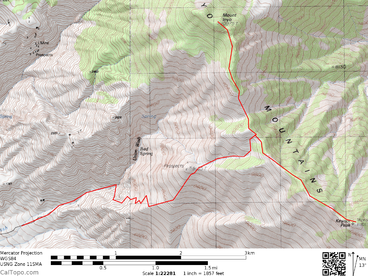
DRIVE: These peaks are listed together in this guide because they share a common trailhead. From Lone Pine, CA drive N on US Highway 395 about 0.75 miles to the signed, paved "LP Nar Ga" Road (Lone Pine Narrow Gauge Road). Turn right (E) here, following the paved road 3.0 miles to a fork at the signed junction of the Dolomite and L.P. Owenyo roads. This junction is located just after passing under a set of high voltage power transmission lines. Bear left (NW) here, following the mostly paved road appr oximately 5 miles to a poor dirt road heading right (ENE) toward the mountains. A pile of truck tires has ma rked this intersection in the past, so be looking for them as a check on your location. Turning right here, drive 1.7 miles to a fork. 2WD's should park. 4WD's can bear left at the fork (im mediate steep downhill) and continue E up the alluvial fan for about 0.5 mile to a parking spot near 5100 feet elevation. Although the road continues, the section that crosses Union Wash is washed out and impassible. There are pullouts enough for a possible 4 vehicles here.
CLIMB: From the 4WD parking spot continue 0.3 miles and drop into the large, rocky wash just to the north. Hike 0.5 miles E up the wash to a point about 100 yards from where the canyon necks down to a narrow slot. Water can oft times be found flowing at this slot. At this point bear right to a reddish colored talus and scree slope, picking up a fair to poor use trail. Follow the trail carefully as it switchbacks up loose slopes to gain the ridgeline above at approximately 8,000 feet elevation. Here the trail heads NNE toward a whitish rock outcropping designated as point 9155 on the topo map, skirting along its right side to a ridgeline saddle just E of point 9155. Continue ENE on trail up a shallow canyon to a saddle on the crest of the Inyos at 10,080+ feet elevation. It is here that you turn either left or right to climb Mt. Inyo or Keynot Peak. En route to this saddle you'll pass a few dry campsites unofficially known as Bedsprings Cam pamong the pines at 9,400 feet elevation. These sites offer reasonable overnight camping for hikers backpacking these peaks. Although there is no permanent running water at Bedsprings Camp, patches of winter snow often linger in the shade here until late spring, offering a good source of drinking water for campers.
Following are the directions to the summit of Mt. Inyo: From the saddle at 10,080+ feet elevation, turn left (NNW) and hike the slightly undulating crest about 1.25 m iles to the rocky, wooded summit of Mt. Inyo. Ridgeline crags encountered in the last 0.25 miles or so are bypassed low along their left (W) side to the final rock outcropping, which is climbed directly to the summit via class 2 boulders.
Following are the directions to the summit of Keynot Peak: From the saddle at 10,800+ feet elevation, turn right (SE), following a faint trail staying mostly along the right (W) side of the crest for about 0.75 miles. Here the Inyo crest changes from a gentle whitish lim estone ridge to jagged reddish-brown crags. Either follow a loose, tedious ducked trail along the right (W) side of the crags or easier, essentially trailless slopes beneath the left (E) side of the crags for about 0.5 miles to the summ it area. If snow covers the eastern slopes of the crest, the terrain in that direction can be difficult to negotiate. Regain the crest near the summit and walk to the top.
The descent of Inyo/Keynot can be made lightning fast from about the 8000 foot elevation level to the wash at the base of the mountain. Great scree slopes abound in this region, allowing one to “walk” down an avalanche of scree in a fraction of the time it took to hike up this slope on the trail. From Bedsprings Camp you could conceivably be back to the 4WD parking spot in under 2 hours.
ROUND TRIP STATS/EITHER PEAK/4WD: 6200 feet elevation gain, 10 miles, 12 hours
ROUND TRIP STATS/BOTH PEAKS/4WD: 7200 feet elevation gain, 13.5 miles, 14 hours
SIDELINES
- It's a very strenuous trip to do both peaks in a dayh ike from the Owens Valley. If you're not in shape or are a slow hiker, you probably shouldn't even consider doing it this way. Plenty of strong hikers attempting both peaks in one day have been known to return to the cars well after dark. As an alternate to this marathon hike, consider backpacking up to Bedspring Camp the first day and bagging the peaks on the following day with a late afternoon return to the cars. Plan on carrying water with you for two days.
- Good times of the year to do these peaks are autumn and spring. Between the onset of autumn (October) and the first snows of winter (December), these peaks are routinely climbed. During this period you shouldn't count on any water (in the form of snow) being available along the route. During the spring however, you are likely to find snowbanks in shady recesses along the way. One such snow patch is usually found near the Bedsprings campsite, making this a popular spot to set up camp when backpacking these peaks. Perhaps the only disadvantage to a spring climb is that the snow can be heavy on the E side of Keynot Peak, making the climb more demanding than usual.
- Keynot Peak and Mount Inyo are the second and third highest points respectively in the Inyo Range. Waucoba Mountain holds the distinction of being the highpoint of the Inyo Range.
- According the W. A. Chalfant in his book The Story of Inyo, the Inyo Range was given its name by the local Indians. Chief George, a Paiute Leader during the mid 1800's told the local white settlers that the name Inyo meant "the dwelling place of a great spirit".
- Views west from the summ its of Inyo and Keynot include peaks of the Mt. Whitney area, Lone Pine, the Alabama Hills and Owens Dry Lake. To the east lies the deep sink of Saline Valley and numerous mountain ranges of the Death Valley region.
- There are numerous other routes to the top of Mt. Inyo and Keynot Peak. Some hearty souls have climbedKeynot Peak from Saline Valley via the ridge just N of Beveridge Canyon, making their adventure a 10,000+ foot elevation gain odyssey requiring great patience a nd stamina. Another route on Keynot Peak is from Forgotten Pass, a saddle in the Inyo Crest located a bout 1.0 miles SSE of Keynot Peak. Access to Forgotten Pass is via a primitive trail from the French Spring area on the Owens Valley side, making this a 12 m ile, 6500 foot elevation gain round trip. Also recently popular have been explorations of the side canyons of the Inyos as well as grand traverses of the Inyo Crest from Waucoba Mountain in the north to New York Butte in the south, passing over the summits of Mt. Inyo and Keynot Peak en route. Needless to say, there are many ways to reach these summits, with probably a few more routes left to be discovered.
- Just before reaching the final rock outcropping marki ng the sum mit of Mt. Inyo, keep an eye open for an interesting natural rock shelter on the W side of th e Inyo crest near UTM 123656. It's a large hole under a massive, sloping boulder with its entry facing toward the south. This shelter is distinguished by a brass plaque on a nearby pine tree, dedicating it to the memory of Marion Howard, a beekeeper in local McElvoy Canyon from 1965 to 1980. In a pinch, the shelter could offer so me respite from inclem ent weather for a few hikers.
- Mount Inyo and Keynot Peak are located within the boundaries of the Inyo Mountains Wilderness Area. This new wilderness area was created as a part of the California Desert Protection Act of 1994, Public Law 103-433, Section 102 (28). The Inyo Mountains Wilderness Area encompasses approximately 205,020 acres of land and is managed by the United States Forest Service in its northern part and the Bureau of Land Management in its central and southern parts.