Guide
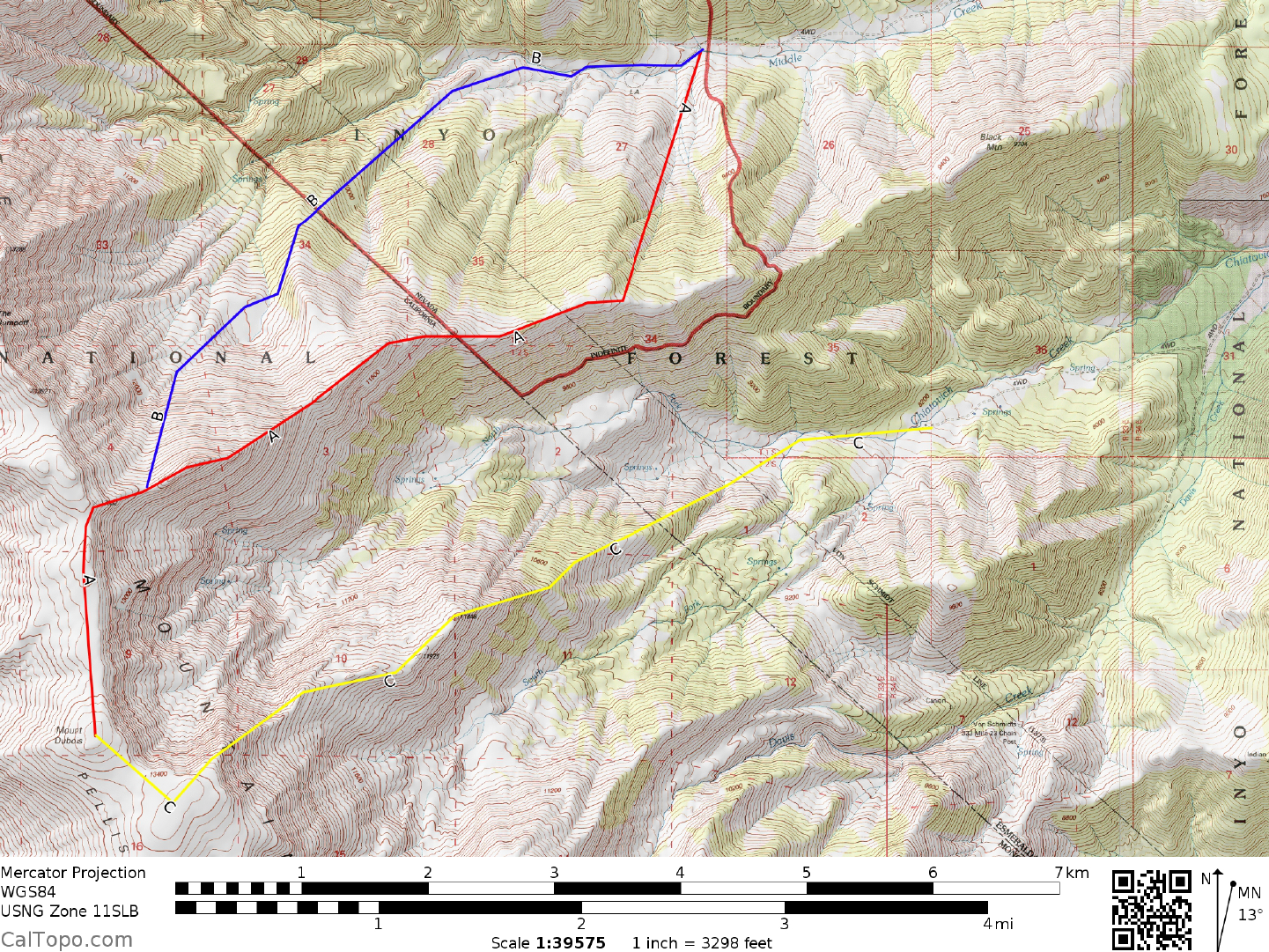
DRIVE: From Big Pine, CA. drive 37 miles E on State Route 168 over Westgard Pass to the town site of Oasis. Turn left (N) on State Route 266 and drive 15.1 miles to Dyer, Nevada (Upon crossing the state line the route number changes to State Route 264). Because this is open range land, beware of cattle on the road here, especially at night. From the Dyer Post Office , continue N on Nevada State Route 264 for 12 miles to its intersection with the signed Chiatovitch Road. Turn left (W) here and drive on the fair dirt road to a signed forks for Trail and Middle Creek Canyon . Continue following the signed forks until you pass a green building on your right. The road will fork one more time, right will take you up to Trail Canyon, the starting point for Boundary and Montgomery) left will take you to Middle Creek. Drive 3.3 miles of poor dirt to 4WD road to the starting point for the climb, a pullout near the 8400 foot level on the N side of the creek. Park.
CLIMB/ROUTE A: Cross the creek and ascend the obvious, relat vely brush-free slope to the main E ridge somewhere between points 9657 and 10975. Follow the E ridge up over point 12044 and then either up over point 13120+ (UTM 826846) or just below it on its left (S) side to the 13000+ foot saddle at UTM 823844. From the saddle, climb easy slopes to the summit plateau and then head SSE for about 1 mile either over or around point 13449 on your way to the summit.
CLIMB/ROUTE B: Walk W up the 4WD road to its end in approximate ly 0.25 miles. Pick up a faint trail here and follow it W for about 0.3 mile s to a large, vertical rock cliff adjacent to the creek on its N side. Crossing the creek here, ascend the steep opposite bank and head WSW across flat, brushy terrain for about 0.5 miles. Picking any likely looking route from this poi nt (bru shy in this area), diagonal right up into the pine forested slopes, working your way over to a large flat area at 11,000 feet elevation (UTM 830857). From here climb SSW up loose slopes and a gully, intersecting the main E ridge at the 13000+ saddle (UTM 823844) and joining up with Route 1, which is followed to the summit. NOTE: If you are climbing Dubois in the snow, Route B makes for a fine descent, cutting off possibly an hour or more from a Route A descent. In general however, Route B can be quite brushy depending on how well you pick your way up from the roadhead to about the 10,400 foot level.
ROUND TRIP STATS/ROUTE A OR B: 5800 feet elevation gain, 12-13 miles, 10 hours
SIDELINES
- There are good camping sites to be found among the pines and aspens along the N bank of Middle Creek. After a very long day on Dubois you'll probably appreciate the short drive to these sites. Remember to boil or filter any water from the creek that will be used for drinking.
- Dyer, Nevada is the closest town to the Dubois trailh ead and has a gas station and general store, restaurant/bar and a post office. About 2.9 miles N of Dyer on State Route 264 is the turnoff for "Fish Lake Community Center and Park". The park, located about about 0.3 miles W of the highway, has overnight camping, water and flush toilets.
- The high, exposed country along the spine of the White Mountains from Westgard Pass to Montgomery Pass is at times subject to high winds, lightning and violent storms which blow east from the Sierra Nevada. Articles in the Desert Sage newsletter have told of DPS trips to this area that encountered white-out conditions during the normally benign months of summer. Since you will be a long way from the cars while on the summit of Dubois, be prepa ed with adequate foul weather gear and know how to use a topo map and compass should you get caught in an un expected storm. This same warning applies for Boundary and Montgomery Peaks, Guide No's. 1.3 & 1.4 respectively.
- Point 13,120' is known as Peak 13,080' on Peakbagger.com. There is an old film cannister with a Barbara Lilley/Gordon MacCleod register located in a cairn on its summit. In May of 2017 the register was soaked and in no condition to be opened.