Guide
DRIVE/ROUTES A & B: From Big Pine, CA. drive 37 miles E on State Route 168 over Westgard Pass to the town site of Oasis. Turn left (N) on State R oute 266 and drive 15.1 miles to Dyer, Nevada (Upon crossing the state line the route number changes to State Route 264). Because this is open range land, beware of cattle on the road here, especially at night. From the town of Dyer, continue N on Nevada State Route 264 for 11.7 miles (0.7 miles N of highway milepost 19) to its in tersection with the unsigned Middle Creek Canyon Road. Turn left (W) here and drive 7.1 miles on the fair dirt road to a signed fork. Bear right (NW) on a poor dirt road (a left will take you up Middle Creek to the roadh ead for Mt. Dubois) and drive 4.3 miles to a fork. Bear left (SW) at this fork and go 1.9 miles to the end of a jeep trail at 9000 feet elevation in Trail Canyon. Park.
ALTERNATE DRIVE/ROUTES A & B: The following route is longer in both mileage and time if you are approaching Big Pine from the S on US Highway 395. It is included here because it is the obvious route of choice for those seeking this peak from Bishop, it being faster than driving S to Big Pine and then over Westgard Pass. From Bishop, CA. drive 60 miles N on US Route 6 to Nevada State Route 264, en route going over Montgomery Pass at the northern end of the White Mountains. Turn right (SE) on State Route 264 and drive about 8 miles to a signed junction for Tonopah, NV. From here continue S on State Route 264 for 6.0 miles to its intersection with the unsigned Middle Creek Canyon Road. Follow the above DRIVE/ROUTES A & B directions from here to the trailhead.
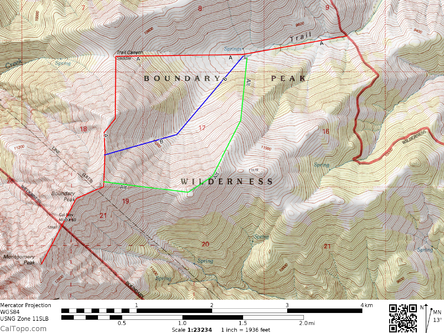
CLIMB/ROUTE A: See Map 1. Hike W along the S side of the creek for about 2.5 miles to Trail Canyon Saddle. This large saddle is located at 10,800 feet el evation on the crest of the White Mountain range and has a com manding view of the Sierra Nevada to the west and the vast expanse of the Great Basin to the east. Follow a poor trail system that switchbacks up steep scree and talus slopes to a small saddle on the ridgeline above. From the saddle the trail traverses a steep slope SSE a short distance to regain the main ridgeline. Continuing up the ridge, follow a system of poor trails 0.5 miles S to easier terrain near the summ it, keeping to either side of the ridge as obstacles present themselves. From here it's a short 0.2 miles hike SW to the summit. NOTE: See Mt. Dubois, Guide No. 1.5, Sidelines 3 for trip planning inform ation.
CLIMB/ROUTE B: See Map 1. Hike W along the S side of the creek for about 1.25 miles to the 9700 foot elevation level. Head SW from here up a canyon to a bout 10,600 feet elevation, then W up steep slopes to the crest at 12,080 feet elevation. Continue S up the ridge, follow a system of poor trails 0.5 miles to easier terrain near the summit, keeping to either side of the ridge as obstacles present them selves. From here it's a short 0.2 miles hike SW to the summit.
ROUND TRIP STATS/ROUTE A OR B: 4200 feet elevation gain, 8 miles, 8-9 hours
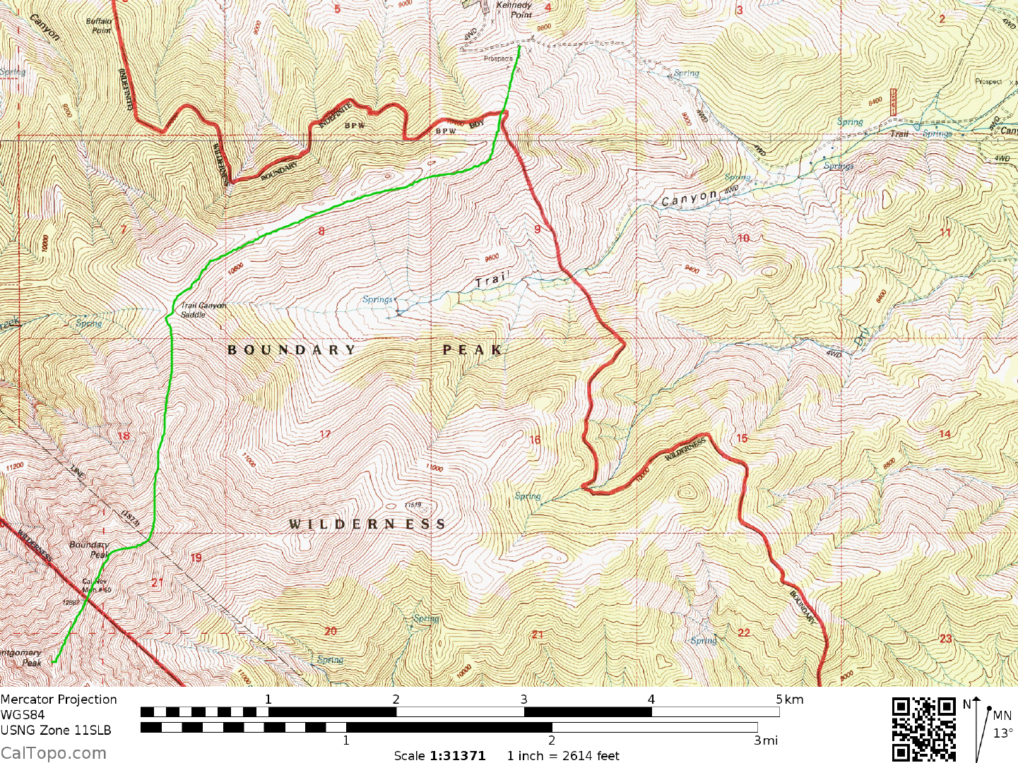
DRIVE/ROUTE C: From the intersection of US Highways 395 and 6 in Bishop, CA drive approximately 43 miles N on US Highway 6, crossing the state line into Nevada and driving 2.5 miles to a dirt road turnoff on the right (E) side of the highway. This dirt road turnoff is located 0.5 miles N of US Highway 6 milepost marker 2. Turn right here on good dirt and drive 1.3 miles to a fork. Bear left and drive 0.6 m iles to a fork. Bear right, driving 1.3 miles to a cattle guard crossing. Continue E up the canyon another 1.3 miles to a fork near some old cabins. Keeping left (straight) and ignoring all m inor road branches, continue following the main dirt road another 1.4 miles to a flat area and tailings pile near a mine site. Standard 2WD vehicles should park here. 4WD's can continue beyond the mine site another 1.2 miles up a switchbacking road along a hillside to a broad saddle at 9900 feet just S of Kennedy Point. Park.
CLIMB/ROUTE C: See Map 2. Head S up a vehicle track a very short distance to two horizontal cuts across the face of the hillside. At the left end of these cu ts pick up a trail (sometimes faint and broken) which switchbacks S up the hillside to near the skyline ridge. Here pick up a fairly good trail heading SW along the right (N) side of the ridge, it eventually switching to th e left (S) side of the ridge and continuing about 1.5 miles WSW to Trail Canyon Saddle at 10,800 feet elevation. Boundary Peak comes into view en route along the ridge to Trail Canyon Saddle, looming largely 2.5 air miles to the SW. Joining up with Routes A & B here at Trail Canyon Saddle, bear S and follow a poor trail system that switchbacks up steep scree and talus slopes to a small saddle on the ridgeline above. From the saddle the trail traverses a steep slope SSE a short distance to regain the main ridgeline. Continuing up the ridge, follow a system of poor trails 0.5 miles S to easier terrain near the summit, keeping to either side of the ridge as obstacles present themselves. From here it's a short 0.2 miles hike SW to the summit.
ROUND TRIP STATS/2WD/ROUTE C: 4300 feet elevation gain, 11 miles, 9-10 hours
ROUND TRIP STATS/4WD/ROUTE C: 3600 feet elevation gain, 8.5 miles, 8 hours
SIDELINES
- Boundary Peak is the highpoint of the state of Nevada. The state line runs diagonally from NW to SE through the saddle between Boundary Peak and Montgom ery Peak, cutting off the much more impressive and higher Montgomery Peak from that distin ction by about one half of a mile.
- Camping spots may be found at the end of the road for route A. There is no reliable water or toilet facilities. It may be possible to find primitive camp spots at the trail heads for routes B and C as well.
Guide provided by the Desert Peaks Section