

|
This peak guide is presented for the convenience of our visitors.
|
|||
|---|---|---|---|
|
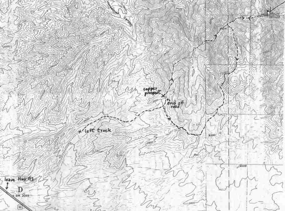
This guide is based on a Sage article by Bob Michael Topo Map: Mount Wilson 7½ DRIVINGThe access road turns east from US Highway 93 about 6-1/4 miles southeast of Hoover Dam; the road is hard to spot, and you'll probably cruise right by it the first time as we did. This rough, poor road - 4WD highly recommended - goes about 2-1/2 miles to an old copper prospect at precisely the start of the route at 3000' HIKINGFrom the copper prospect, the route goes directly N up the obvious ridge, then NE over rough, rocky point 4154', losing about 160' of elevation on the E side of this point before the long final pull up the W ridge of Wilson. This ridge is of moderate difficulty, with easy stretches alternating with steep boulder pitches. However, the overall sustained nature of the climb, along with the low start a mile down the road and the unusually warm February day (81', a record for the date, in Vegas) made for a fairly grueling ascent. Since we got a late start, we chose to avoid the slow going on the ridges on the descent by cutting down the southwest flank of the peak into a prominent canyon, exiting west out the lower end of this wash to rejoin the road near the copper prospect. Nonetheless, we reached the truck well after dark. NOTESJust on the far side of Hoover Dam is a peak that fairly begs to be placed on THE LIST. From Las Vegas, Mount Wilson is very prominent on the southeast horizon, and shows a handsome profile which reminds me a bit of Sawtooth Peak from the upper stretch of the Mineral King road. The summit view has got to be as good as that from any desert peak on the List; east far across the Detrital Valley (love that name) to the Grand Wash Cliffs, the ramparts of the Grand Canyon country; to the north and east, almost all of Lake Mead is visible, from Hoover Dam to the Overton Arm, the large bay on the east end of the lake where the Virgin River enters. Beyond the lake, Virgin Peak and the wild rugged country south of it in the remote southeast tip of Nevada (Gold Butte, Bonelli Peak). Westward we could plainly see the Luxor "Pyramid" on the Strip, almost the entire Spring Range, and Clark Mountain in California. To the south, the strand of the river led past Spirit Mountain and the mountains around Oatman. |
|
||||||
| Desert Peaks Section, Angeles Chapter, Sierra Club © Copyright 1998-2012 - All Rights Reserved Updated: February 9, 2012 |