

|
This peak guide is presented for the convenience of our visitors.
|
|||
|---|---|---|---|
|
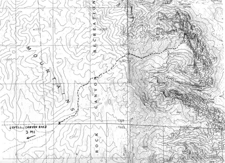
This guide is based on a Sage article by Bob Michael Topo Map: Blue Diamond 7½ DRIVINGTo reach the roadhead, turn east from I-15 in south Las Vegas onto Nevada Highway 160 to Pahrump. About three miles west of the pass at Mountain Springs, watch on the right for the paved Lovell Canyon Road which heads north. Three miles from 160, a fair dirt road (2WD high clearance, not suitable for cars) turns off to the NE; there was a cairn at this junction in April '96. The road ends in Pinyon forest in a wash at a barrier erected by the BLM to mark a Wilderness Study Area boundary (El. 5790'). HIKINGthe route heads generally northeast up narrowing and sometimes brushy washes and gullies in pleasant but very nondescript pinyon-juniper country; finally, the brushiness of the narrowing gullies forces you onto a ridge. The goal is point 6,968' (2124 m) on the one o Mountain crest. Directly ahead is the broad Ponderosa-dotted tawny back of Wilson. (From here the slickrock looks third class; it isn't.) Immediately below Point 6968' is the one nasty part of this route, a very steep and unpleasant traversing descent down treacherous, loose limestone rubble down the east face of the divide. It is impossible to follow the cliffed ridgeline east from Point 6968'; the only doable route descends to the north of the point. It is important to lose a lot of altitude fast and then traverse over to the flat part of the ridge at about 6,400'; any attempt to traverse higher wilrend up in dangerous rotten cliffs. And, as bad as this stretch is going down, it's worse coming back up. Once safely on the west ridge of Wilson, the rest of the trip is pure ecstasy. The route goes quite easily over the slickrock to the little summit knob, where half a mile of rock simply ceases to exist right in front of your eyes; the view down to the desert floor is very much like looking down from an airplane. To the north and south, great parapets and fortresses of naked multicolored rock soar across unimaginably deep canyons. NOTESMount Wilson, highest point of the Red Rocks cliffs southwest of Las Vegas, Is rather like El Capitan; the back side is a hike, the front side a big wall. (I assume my readers are more inclined to the hike ascent.) I would rank this peak among the top 5 of the DPS list (right up there with Picacho del Dialo) in terms of the sheer exhilaration and wonder of just being there. |
|
||||||
| Desert Peaks Section, Angeles Chapter, Sierra Club © Copyright 1998-2012 - All Rights Reserved Updated: February 9, 2012 |