

|
This peak guide is presented for the convenience of our visitors.
|
|||
|---|---|---|---|
|
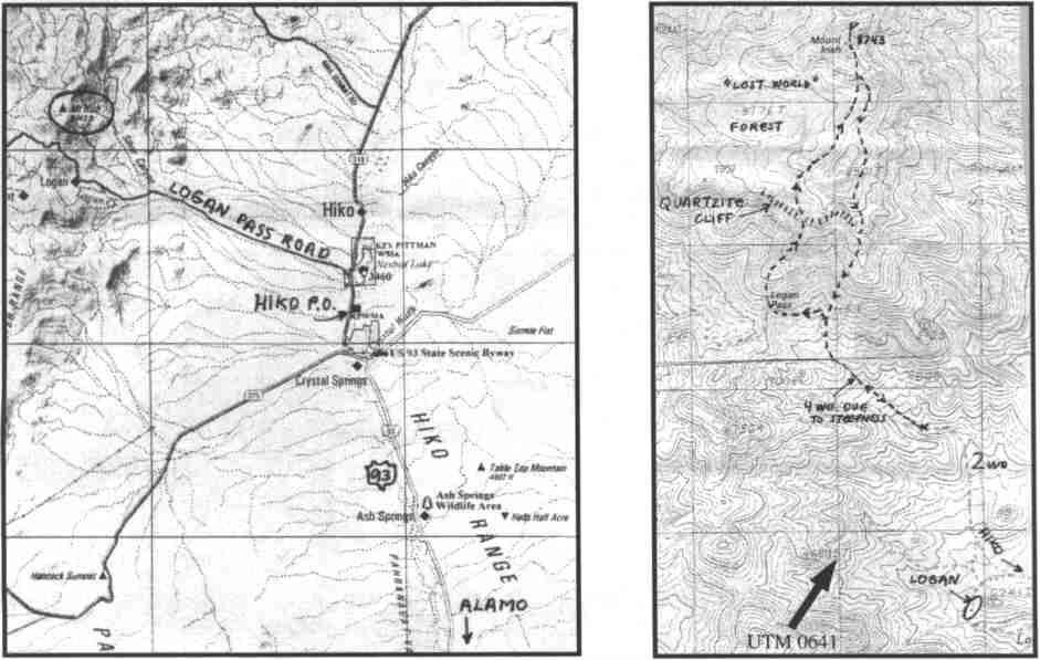
This guide is based on a Sage article by Bob Michael. Topo Map: Mount Irish 7½ DRIVINGThe unsigned dirt road to Logan Pass takes off from Nevada Highway 318 on the west shore of a reservoir about a mile north of the Hiko post office. It's very easy to miss, especially because there's a closed (unlocked) fence gate where the road takes off. This fairly good 2WD road (marginal high clearance) passes some bouldery rhyolite passes some bouldery rhyolite outcrops about 6 mi W of the highway. The better road goes left to the abandoned townsite of Logan; the Logan Pass road veers right, steepens,and deteriorates. A 4WD could have made it to the pass, but 2WDvehicles should park at about 6500'. HIKINGThe route begins at the pass, heading N up a ridge. Beginning at about 7850', the tough quartzite formation caps this ridge, and going was slow ardious up and down blocks and mini-crags. The quartzite forms a fairly continuous cliff band, and you can find a cl 2 passage through it. Above this point the route flattens out to the summit plateau; a few scattered Ponderosas and white fir appear. When you cross a ridge into a broad central valley, you suddenly enter a Ponderosa fir forest (with even a few bristlecones). As the summit is on the far (N) side of this plateau; going up the south side, one reenters the pinyon/mountainmahogany zone. Regretfully, the top is defaced with a robot electronic site; at least, it's accessed by helicopter, so there is no road. The register records mostly military-types with helicopter "ascents" and a University of Nevada botanical survey team NOTESIrish, like most southern Nevada peaks, is an upfaulted chunk of paleozoic sedimentary rocks, mostly limestone with quartzite. Unlike most in this area, the beds have been lifted straight up with little rotation, so they are pretty much flat-lying, like buttes on the Colorado Plateau to the east. A massive, resistant quartzite unit whose top is at about the 8,000-foot level provides both the "crux" of the route from the south, and the erosional floor for the summit plateau were the "lost" forest grows. From the summit you can see pretty much across the southern half of the state, from Charleston to Virgin (!) to the solid white Snake Range (Wheeler) to Jefferson. Much closer, to the southwest is 9,348' Bald Mountain, highpoint of the Groom Range. |
|
||||||
| Desert Peaks Section, Angeles Chapter, Sierra Club © Copyright 1998-2012 - All Rights Reserved Updated: February 9, 2012 |