

|
This peak guide is presented for the convenience of our visitors.
|
|||||
|---|---|---|---|---|---|
|
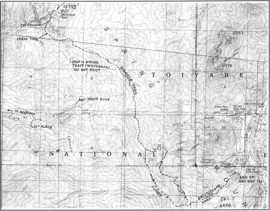
This guide is based on a Sage article by Bob Michael. Topo Map: Charleston Peak 7½ DRIVINGDrive to the Bristlecone Trailhead at the end of Nevada Highway 156 at the Lee Canyon Ski Area. HIKINGLeave the Bristlecone Trailhead at 8670' and, after 2.5 pleasant miles it joins the Bonanza Trail on the Spring Mountain crest at 9760'. The Bonanza Trail, here welldefined, heads NW along the main divide of the Springs and is a scenic and delightful hike in a lovely old bristlecone forest. Considerable ups and downs in this stretch make the total altitude gain much more than just the difference between the trailhead and the summit elevations. Ahead loom the forbidding grayish white limestone battlements of McFarland, looking quite unclimbable from this side, reminiscent of the Italian Dolomites - similar geology, even. The trail drops to the W side of the crest below the SE toe of McFarland's ramparts, and cuts down to the W below big switchbacks as the S face; it does not drop in erroneously shown on the topo. Just about when you're starting to complain about all the altitude loss, there is the stone "Michelin Man", rock formation, which looks a bit like the Michelin Tire man with his stack-of-doughnuts belly with a dead snag leaning on it. A steep, sliding sidehill traverse here takes you into the couloir at about 9450'. It's not too bad for a few hundred feet of gain, through steep pine trees, mostly on soil. Then, the terrain steepens, the soil is replaced by treacherous limestone scree at the angle of repose, and the first vertical impasse is met. It initially looks better to go right, but this will always come to grief in this couloir; the simple key to a successful ascent is to always go left even if that doesn't look as good from below. Then climb one little easy class 3 pitch and find a wildly steep but surprisingly doable chute - even some pine trees, and soil to kick into that was completey hidden from below. This chute ends at a notch at 10,515' on Mc Farland's gentle summit area. A stroll up to the right and you are on top the toughest big peak in southern Nevada. The register, which dated back to 1967, had several comments to this effect. The view to the SE was such as skydivers see; the edge rolled away to an abyss of empty space. NOTESThe North Palisade, the Big Picacho of the Spring Mountains is McFarland Peak in the wild, rugged country at the north end of the high Spring Mountains. This peak bares its fangs of thousand-foot cliffs to climbers approaching from the south and east sides. The terrain on the northwest side is gentler, but access is difficult because of private property on the west and long arduous approaches from the north. Featured on the new "Nevada Peaks List", it is without a doubt the toughest high peak in the Spring Mountains. |
|
||||||
| Desert Peaks Section, Angeles Chapter, Sierra Club © Copyright 1998-2012 - All Rights Reserved Updated: February 9, 2012 |