

|
This peak guide is presented here for the convenience of our visitors.
|
|||
|---|---|---|---|
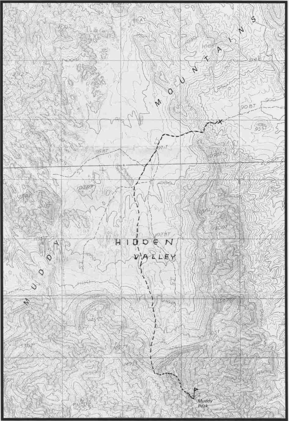
This guide is based on a Sage article by Bob Michael. Topo Map: Muddy Peak 7½ DRIVINGLeave Nevada 1-15 at Exit 75, signed "Valley of Fire, Lake Mead", State Route 169. Drive 3.1 miles SE on Route 169 to where the road starts curving left (less than 0.1 miles past highway mile·post 3). Leave Route 169 here, continuing straight (SE) O.1 miles to the end of pavement and start of a good dirt road. A BLM sign here welcomes you to the Bitter Springs Trail, a designated backcountry· highway. Drive 4.0 miles SE to a second BLM sign indicating mileage and directions to Buffington Pockets, Bitter Springs, North Shore Road and Colorock Quarry. Continue straight (SE), following the main dirt road (ignoring any left or right minor forks) for 6.2 miles to a faint dirt road heading generally W towards a low ridge. Turn right here, driving 1.0 miles to the road closure at a large, metal BLM sign. Any, reasonable 2WD standard clearance vehicle should be able to make it to here. Park. past the Colorock Quarry, the road could be rough on a standard passenger car. The metal sign referred to marks the boundary of a BLM wilderness study area. A steep jeep road which continues past the boundary has been "decommissioned". HIKINGHike up this road and drop over a low saddle into Hidden Valley, one of the sacred and magical places of the desert. Leave the old road in the middle of Hidden Valley and hike up a convenient shallow wash on gentle terrain towards the prominent notch on the southern skyline that separates the Muddy Peak massif from the unnamed Muddy Mountains highpoint to the west. The going is pretty easy to this notch. However, the steep, loose, harsh ridge to the east from the notch that leads to the base of Muddy's summit tower is quite trying. The summit tower looks very vertical and intimidating from the ridge. We've all experienced the optical illusion where routes that look horrible from a distance melt into do-ability when you get next to them. But this thing looks worse the closer you get! From the notch below the tower, climb a rather cruddy 3rd class chute just S of the W ridge of the tower. Climbed up and out of the chute and work out to the right on a somewhat exposed little rib. This rib leads right to the summit. NOTESAs you head east on I-15 from Vegas towards Moapa and Virgin, you must have noticed a dramatic tower-like peak poking the southern horizon west of Valley of Fire; this spire has the uninspiring name of Muddy Peak. This peak is so list-worthy it's ridiculous!. It's got everything; a beautiful wilderness approach; commanding views; and adrenaline-pumping third class. From the summit there are sensational views Lake Mead, Valley of Fire, the tortured naked rock of southern Nevada stretching east towards the Virgin Mountains and the western ramparts of the Coconino Plateau. |
|
||||||
| Desert Peaks Section, Angeles Chapter, Sierra Club © Copyright 1998-2010 - All Rights Reserved Updated: February 9, 2012 |