

|
This peak guide is presented for the convenience of our visitors.
|
|||||
|---|---|---|---|---|---|
|
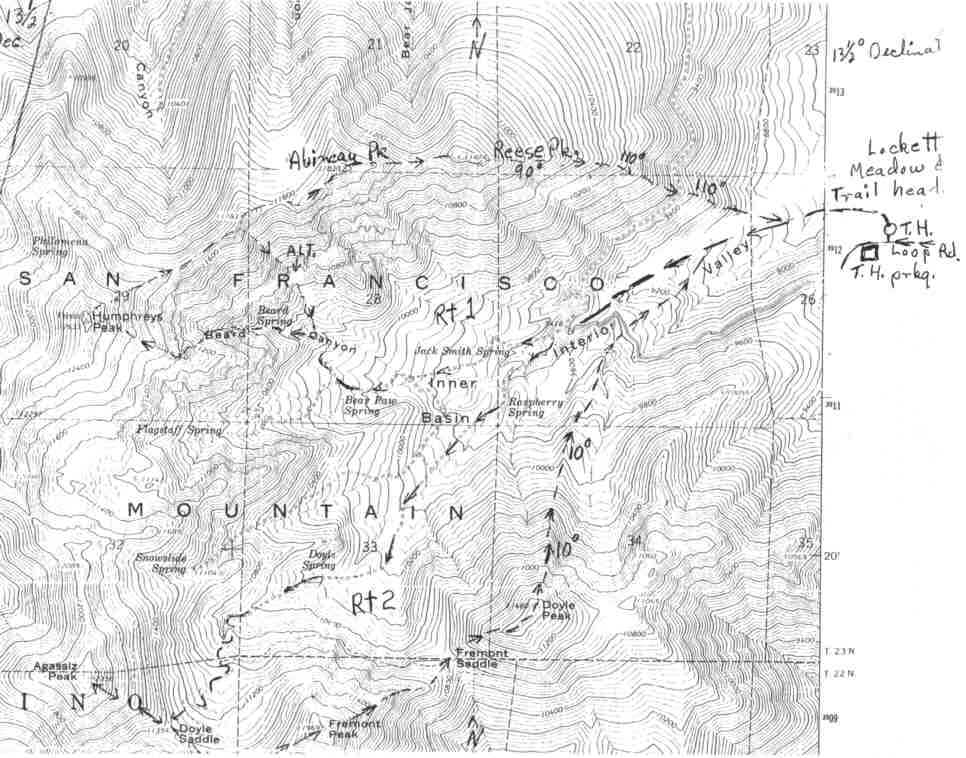
This guide is based on a Sage article by Ted Brasket. It combines Agassiz, Fremont, & Doyle Peaks. Topo Map: Humphreys Peak 7½ DRIVINGFrom exit #201 on I-40 east of Flagstaff take highway 89 north for 13.8 miles. Turn left toward the peaks on an excellent dirt road. (This turn off is .8 mi. past the Sun Set Crater junction.) Drive 1.2 miles to the signed Lockett Meadow road on the right side. Drive this steep good dirt road 2.8 mi. to the beginning of a one way loop around Lockett Meadow. Beautiful camp sites are located around this loop. The trailhead and trailhead parking are .4 mi. from the beginning of the one way loop. The trailhead is a closed road behind the outhouse just right of the loop road. HIKINGFrom the same trail head follow the route one directions 1.5 miles to the cross roads and green buildings. Continue up the route one road a short distance and take the left hand road at the junction. This will take you the full length of the beautiful, open, Inner Basin. There are several lesser roads going off to the right to dif-ferent springs. Stay left to the end of this road. A narrow trail goes sharp left and into heavy vegetation near roads end. This road hasn't been in use this far up and has vegetation growing on it. Keep a sharp eye to the left or you may not see the duck on the ground at the beginning of the trail. Follow this switch back trail up through beautiful forest. There's a junction high up. Go right and on up to the 11,354 saddle between Fremont and Agassiz. It's a 1000 ft. gain from this saddle to the 12, 358 ft. Agassiz Peak summit on a steep stable ridge. Back down to the saddle and up to the 11,969 ft. Fremont summit is a 700 ft. gain. A 1200 ft. drop on a challenging ridge puts you on the saddle between Fremont and Doyle. The gain to Doyle is 800 ft. The high point on the long Doyle summit is on the north end. Following a 10° compass bearing off the end of Doyle will take you down a steep ridge to a road S.E of the spring, 1.5 miles from the trail head. Look for a gate across this road. There's a trail there that will take you down to the road and back to the trail head. NOTESThis routes begin from the beautiful, undeveloped camp sites at Lockett Meadow. Elevation 8600 ft. The camp sites are under large Ponderosa Pines. No tables or water. Most have rock fire rings. There is a toilet at the trail head but was out of order.Fine camp sites, great hiking through the forest, including the longest stand of the biggest Aspen we've seen anywhere. Makes fantastic fall colors. You're able to see every high peak and ridge in this range from the basin. Then there's Beard Canyon, big walls, rock formations and weather sculptured Bristle Cone. |
|
||||||
| Desert Peaks Section, Angeles Chapter, Sierra Club © Copyright 1998-2012 - All Rights Reserved Updated: February 8, 2012 |