

|
This peak guide is presented for the convenience of our visitors.
|
|||||
|---|---|---|---|---|---|
|
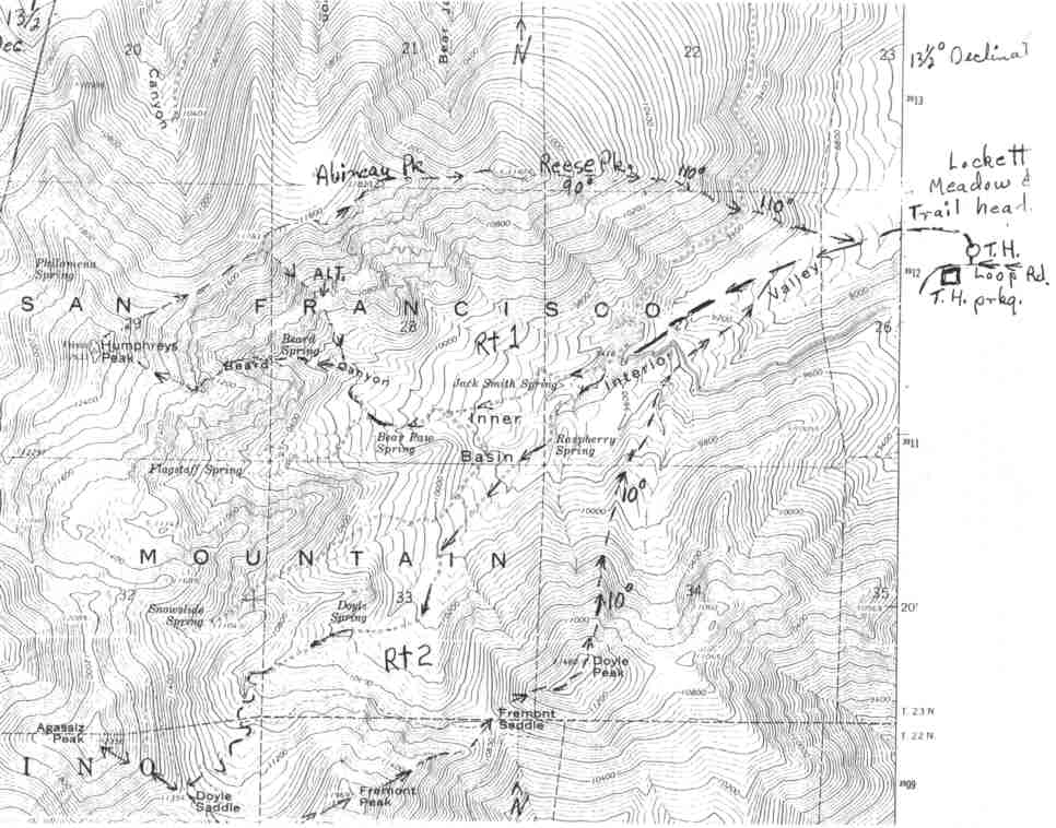
This guide is based on a Sage article by Ted Brasket. It combines Humpreys, Aubineua, & Rees Peaks. Topo Map: Humphreys Peak 7½ DRIVINGFrom exit #201 on I-40 east of Flagstaff take highway 89 north for 13.8 miles. Turn left toward the peaks on an excellent dirt road. (This turn off is .8 mi. past the Sun Set Crater junction.) Drive 1.2 miles to the signed Lockett Meadow road on the right side. Drive this steep good dirt road 2.8 mi. to the beginning of a one way loop around Lockett Meadow. Beautiful camp sites are located around this loop. The trailhead and trailhead parking are .4 mi. from the beginning of the one way loop. The trailhead is a closed road behind the outhouse just right of the loop road. HIKINGFrom the trail head walk around the gate and follow the road 1.5 miles to a spring with two green building on the left and out-house on the right. There's a cross road junction at this point. Avoid the Bear Jaws Spring road to the right. Across the junction a few feet the road you're on turns right for 50 ft. then back left. In a short distance the road forks. Bear right at this junction and stay to the right at one more junction farther on. In 30 minutes + or - from the green buildings there's a galvanized precipitation gauge on a 10 ft. tower. Leave the road on the right side and follow the clear spot a short distance. Beyond some trees is a line of short poles supported by rock cairns. Follow the pole line several hundred feet then turn right up hill on an old road bed to a "Beard Spring" sign. The elevation at this point is 10,200 ft. Beard Canyon begins here. Follow this Canyon staying left against the steep bank all the way up. Don't be tempted to take the large washes coming in from the right. When you come to a dry waterfall It's CL3 on stable rock up the face or continue up and around a big log and on the CL2 ledges to the top. Continue on up the wash to a 5 ft. waterfall. Stay in the a short distance until the Canyon opens up with high walls in front of you and Beard Canyon swings left. Exit the wash left climbing steeply up along the edge above Beard Canyon. Elevation at the exit point is 10,800 ft. Here is where the heavy breathing exercises begin. It's 1800 ft. to the summit in about .75 mi. Continue climbing up near the edge of the canyon .25 mi. where you encounter high vertical walls. Head for the right end of the wall above the canyon and go left along its base to a slot between the walls. (Heading for the daylight in the slot too soon puts you out into loose junk.) Fifty feet above the slot you're out of the heavy forest. It's a fine place to stop and look around at this beautiful rugged scenery. The ridge is narrow here and on the north side it cliffs off into Beard Canyon. The notch on the south side drops down in spectacular vertical rock chute. Just above this notch is a continuous rock rib running up the ridge. Six feet from the near end is a small unlikely looking notch about 8 ft. up. Go over the rocks at this point and down the other side to safe going. Don't be tempted to skirt the rocks on the right side. It leads to the cliffs above Beard Canyon. After a short trip up loose lava you get on a good stable ridge held together by beautiful Bristle Cone Pine. This ridge goes directly to the summit. No false peaks on this route. What you see above you is it. If you want a much shorter day and want to take the alternate route marked on the map back to the canyon and to the road, you can study your descent route across the canyon from this ridge. From Humphreys the route is obvious down the N.E. Ridge and over Abineau and Reese Peaks. After a steep 1000 ft. drop the ridge turns into a long stable boulder field then it's up and down back and forth around beautiful Bristle Cone on the ridge over Abineau and Reese Peaks. From Reese Peak follow the compass bearing on the map through the heavy forest on the descent. At the 9500 ft. elevation you cross Bear Jaws Road. Cross the road and jump off in the boulders staying on 110°. This bearing will take you back to the trail head road about .5 mi. above the trail head and back to camp. NOTESThis routes begin from the beautiful, undeveloped camp sites at Lockett Meadow. Elevation 8600 ft. The camp sites are under large Ponderosa Pines. No tables or water. Most have rock fire rings. There is a toilet at the trail head but was out of order.Fine camp sites, great hiking through the forest, including the longest stand of the biggest Aspen we've seen anywhere. Makes fantastic fall colors. You're able to see every high peak and ridge in this range from the basin. Then there's Beard Canyon, big walls, rock formations and weather sculptured Bristle Cone. |
|
||||||
| Desert Peaks Section, Angeles Chapter, Sierra Club © Copyright 1998-2012 - All Rights Reserved Updated: February 8, 2012 |