 and 2 mi. RT) but interesting. We ascended via
a Class 2 wash to the summit ridge, then N along the ridge (exposed and
knife-edged in spots) to the top. See inset map. The descent route was made via
a loose Class 2 chute just S of the summit, making the peak a 2 hour RT climb.
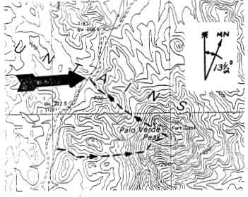
Driving directions to the start of the climb are as follows: From the junction
of State Highway 78 and County Highway S34 (12 miles NE of Glamis) drive 16.4
miles N on Highway S34 to the signed Milpitas Wash Road. Turn left (W) and
drive 0.9 miles on excellent dirt to the signed Palo Verde Road. Turn right (N)
here on a fair dirt road and go 3.7 miles to where you'll see a large, rocky
wash on your right leading up toward the peak. Park (This parking spot is
indicated with an arrow on the inset map). Climbing instructions as follows:
From the parking spot the peak is at bearing 130°. Ascend to the obvious
chute just right of the peak, taking it to the summit ridge. Turn left and walk
to the top.
and 2 mi. RT) but interesting. We ascended via
a Class 2 wash to the summit ridge, then N along the ridge (exposed and
knife-edged in spots) to the top. See inset map. The descent route was made via
a loose Class 2 chute just S of the summit, making the peak a 2 hour RT climb.
Driving directions to the start of the climb are as follows: From the junction
of State Highway 78 and County Highway S34 (12 miles NE of Glamis) drive 16.4
miles N on Highway S34 to the signed Milpitas Wash Road. Turn left (W) and
drive 0.9 miles on excellent dirt to the signed Palo Verde Road. Turn right (N)
here on a fair dirt road and go 3.7 miles to where you'll see a large, rocky
wash on your right leading up toward the peak. Park (This parking spot is
indicated with an arrow on the inset map). Climbing instructions as follows:
From the parking spot the peak is at bearing 130°. Ascend to the obvious
chute just right of the peak, taking it to the summit ridge. Turn left and walk
to the top.Feb 25 - Feb 29 1992 Trip with Ron Jones into Canyon Tajo
Ron Jones and I met (for the first time) at Ontario Airport, and drove toward Tecate. We crossed the boarder into Tecate, then drove 38 miles east on paved Baja 2 to where a dirt road leaves south for Lagnua Hanson. We followed this road due south for about 15 miles, then left it heading south east, and after 4.5 miles parked near the base of a conical peak on the Sierra Juarez plateu.
I had made the trip to the "North Fork Dropin" half a dozen times before over the Last 20 years, and had no trouble finding my way along the Sierra Juarez Plateau to the point where the trail leads down into Canyon Tajo. The plateau is roughly elevation 4,800 feet, with pinion pines and many varieties of Sonora Desert cacti. We crossed the plateau to the east in 20 minutes, and then hiked down the into canyon Tajo, descending steeply about 2,500 feet along well-ducked, rugged trail. Total hiking time was about 2.5 hours. The trail is suitable for external frame packs. Elevation where the floor of the canyon was first reached was about 2,300 feet. This canyon has thousands of palm trees of both the Washingtonia and Blue variety. Ron and I then made our way up canyon, passing the division between north and south fork at the base of the "Great White Throne" and heading roughly a half hour up the south fork of the canyon, where we made camp.
The next day we explored dawn canyon. Ron found numerous pottery shards from previous Indian occupation. We found several rocks with moteros, including one rock with over 20 morteros. Ron hiked further down canyon than I, and reported finding warm springs in a side canyon to the north at roughly 1000 feet elevation below the point where the dropin trail enters Canyon Tajo. At that elevation Ron reported seeing ocatillo in bloom. Higher in the canyon the ocatillo was not yet blooming. We did find some ghost flowers, and some fishook (mamalaria) catus in bloom. We also saw tracks and scat from what seemd to be big horn sheep, coyote, and some sort of cat. Ron found a five pound sledge hammer (probably an artifact from-some misguided prospector) which he put in his pack and carried out.
The second day in the canyon we explored up the south fork, seeking a means of reaching the plateau from the south fork. The main south fork proper became impassible at about 3,300 feet with a 100 foot waterfall on the left, and many jumbled, hard to climb big boulders to the right. At elevation 3,100 feet in the