
9 MEXICO RANGES GUIDE NO. 9.4
CERRO PINACATE 3957 FEET CLASS 1
MILEAGE: 480 miles of paved road, 13.8 miles of good to poor dirt road
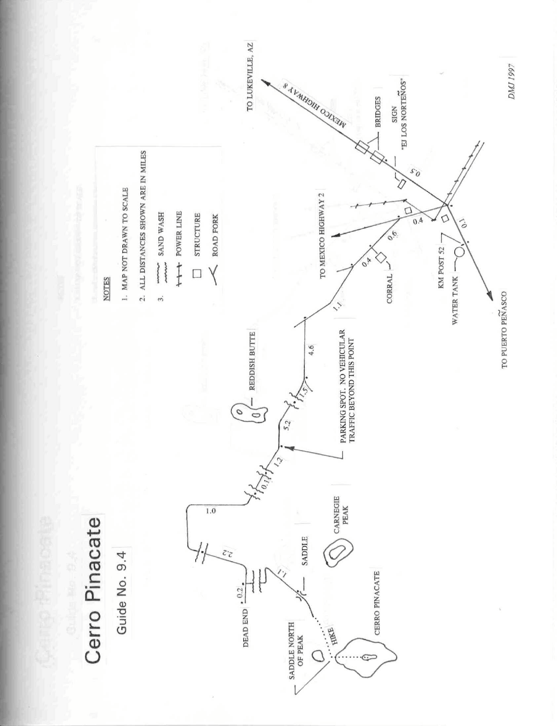
DRIVE: A detailed map has been included showing the driving route from Sonoy
ta to the parking area for
Cerro Pinacate. From the small town of Lukeville, AZ at the southern end of Organ Pipe National Monument,
cross over the International border into Sonoyta. Follow the signs through town directing you south on
Mexico Highway 8 toward Puerto Peñasco (Rocky Point). In about 30 miles you'll come to highway
kilometer post 51 located between two small white bridges. Continue 0.5 miles S on Mexico Highway 8 past
the second bridge to the start of a sweeping left turn where a power line crosses over the road and a large road
sign reads “Parque Nal. El Pinacate” with an arrow pointing right. (If you miss this turnoff, continue driving
S to Highway kilometer post 52 and then backtrack 0.1 miles). Turn right here on a good dirt road and
sign
in at the ranger station. Fees are collected here. Then
drive 0.4 miles to a fork. Bearing left, drive 1.0 mile to a fork.
Bear left and drive 1.1 miles to a junction with a dirt road heading left (W). Turning left here, proceed 4.6 miles
to a fork. Bear right and go 0.3 miles, following the road hard right out of a wash, then 1.2 miles to where it again
crosses the wash. Continue another 5.2 miles to a parking spot just S of a prominent reddish butte. The rough dirt
track continuing up the hill past the parking area is closed to all vehicular traffic.
The area surrounding and including Cerro Pinacate is a Mexican National park and should be treated with the
same respect that we would our own National Parks in the United States. See Sidelines 2 for more details.
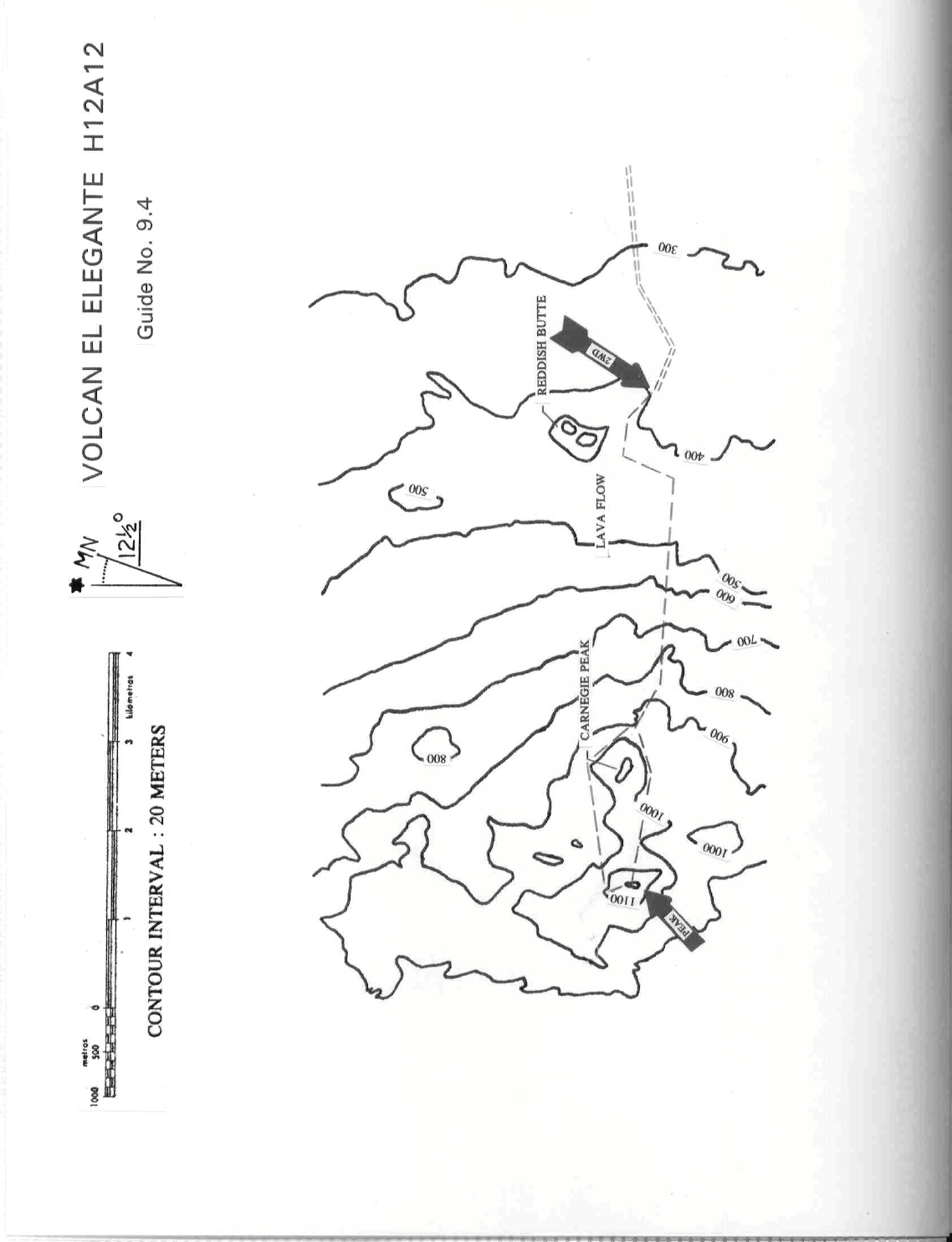
CLIMB: Hike up the hill past the parking spot on the rough dirt track for 0.2 miles to the obvious lava flow.
Head S across the flow to the gully on the opposite side. A faint trail can be picked up on the right side of this
gully and followed W toward Carnegie Peak, Pinacate's eastern neighbor. Traverse either around the N or S
side of Carnegie (a faint trail exists along the southern base of Carnegie to the saddle just E of Cerro Pinacate)
to the base of Cerro Pinacate and then up loose slopes to the top.
ROUND TRIP STATS/2WD: 2500 feet elevation gain, 6 miles, 5 hours
SIDELINES
1. Travel south from Sonoyta to the Pinacate Area and/or Puerto Peñasco does not require a visa from the
Mexican authorities, however travel further into the interior of Mexico does require this formality. Visas are
issued free of charge at the first building on your right after clearing the border check station. Proof of
citizenship is required to obtain a visa. Proof of citizenship includes any of the following documents: A valid
US passport, certified copy of your birth certificate, voter's registration card, armed forces ID, notarized
affidavit of citizenship or military discharge papers stating US nationality and place of birth. A DRIVER'S
LICENSE IS NOT PROOF OF CITIZENSHIP. Naturalized citizens are required to carry an original
Certificate of Naturalization, Certificate of Citizenship or a valid US passport. Taking pets into Mexico, you
are required to have a US veterinarian's certificate (International Health Certificate for Dogs and Cats, form
77-043) stating that the pet is in good health, and a rabies inoculation certificate.
2. Cerro Pinacate is located within the boundary of the Reserva De La Biosfera El Pinacate Y Gran Desierto
De Altar. It is a National Park dedicated to the preservation of the unique natural features, wildlife and plant

CERRO PINACATE (CONTINUED)
9 MEXICO RANGES GUIDE NO. 9.4
species found in this remote part of the Sonoran Desert. Admission to the National Park is $4.00 U.S. now,
and you are required to register with the Park Office ranger before entry, reporting your estimated camping sites and
number of days, party size and vehicle ID. The Park Office and Operations Center, a grouping of white
buildings, is located just off the W side of Mexico Highway 8 about 0.3 miles S of highway kilometer post 51.
Camping is now allowed at the trail head. It is primitive, so bring all water and necessities with you.
3. The International border station at Lukeville, AZ is
open from 6AM to Midnight daily. If you are planning
to cross the border here on a holiday weekend, choose an early time. Many people from Phoenix and Tuscon
go down to Puerto Peñasco on long weekends, making for long lines at the border station.
4. Lukeville offers the following services for travelers; Chevron gas station (leaded and unleaded gas, white
gas and propane available), coffee shop with good Mexican food, coin operated laundrom
at,
general store,
post office, trailer park with hot showers, RV hookups and tent camping area, and a Mexican auto insurance
broker.
5. The Mexican Government Tourism Secretariat maintains the "Green Angels" to help
stranded
motorists.
Known for their green-and-white pickup trucks, the "Green Angels" patrol the highway between Sonoyta and
Puerto Peñasco daily from 8AM to 8PM. Services available include mechanical aid, towing, tourist
information and basic medical first-aid supplies. To summon a "Green Angel", pull off the highway and lift
the hood of your car, or if you have a CB, try reaching them on Channel 9 or 16. Don't expect them to come
after you on dirt roads however; that would be asking a bit much.
6. See SIDELINES 4 and 5, Cerro Pescadores, Guide No. 9.1 for important information on Mexican
autom
obile insurance and gaso
line available in Mexico.
7. Edward Abbey, in his book Beyond the Wall, dedicates a chapter called "The Ancient Dust" to the Gran
Desierto del Pinacate and his climb of the peak in 1968. His entry can be found in the restored (xeroxed)
summit register left by Southern Arizona Hiking Club, an organization that unofficially maintains the register
on Cerro Pinacate.
8. The first recorded ascent of Cerro Pinacate by a European was that of Father Eusibio Fransicso Kino on
October 9, 1698 at the age of 53. He climbed the peak as part of his first entrada into the Pinacate region, a
133 mile long trek starting from San Marcelo de Sonoyta, the old townsite about 1½ miles east of the the
present Sonoyta, Mexico. On November 5, 1706, during his fourth and final journey into the Gran Desierto
de Altar, Father Kino climbed Cerro Pinacate’s neighboring summit, Carnegie Peak, spending the night on the
summit.
3
281
32
81
3
281
32
8
1
Lava
Lava
Lava
Lava
Cpinac
Cpinac
Cpinac
Cpinac
3
2
8
1
3
2
8
1
3
2
8
1
3
2
8
1
CPIN19
CPIN19
CPIN19
CPIN19
CPIN21
CPIN21
CPIN21
CPIN21
1969
1969
1969
1969
CPIN18
CPIN18
CPIN18
CPIN18
Lava
Lava
Lava
Lava
R
e
s
tp
i
n
a
c
a
te
r
o
a
d
Re
s
t
p
i
n
a
c
a
te
r
o
a
d
R
e
s
tp
i
n
a
c
a
te
r
o
a
d
Re
s
tp
i
n
a
c
a
te
r
o
a
d
CPIN16
CPIN16
CPIN16
CPIN16
3281
3281
3281
3281
26
25
26
25
26
25
2
62
5
2
6
2
5
2
6
2
5
2
6
2
5
2
6
2
5
2
6
2
5
2
6
2
5
2
6
2
5
2
6
2
5
1312
1312
1312
1312
1
3
1
2
1
3
1
2
1
3
1
2
1
3
1
2
Mapset was created using MapSetToolKit 1.77
copyleft HWStockman
gps_mapper
1 mi0.75 mi0.5 mi0.25 mi0 mi
MNTN
1/1/2010
11.2°