9 MEXICO RANGES GUIDE NO. 9.2
PICO RISCO 4987+ FEET CLASS 3
MILEAGE: 235 miles of paved road, 34.8 miles of fair to poor dirt road
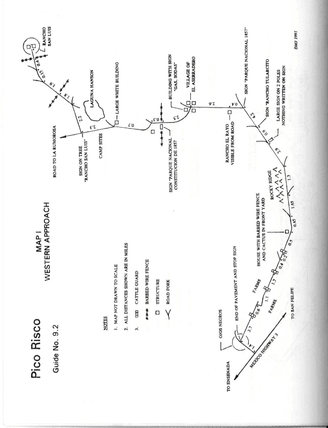
DRIVE/ROUTE A/WESTERN APPROACH: From Ensenada, BC (reached either from Tijuana or Tecate)
drive 25 miles S on Mexico Highway 3 to a signed, paved turnoff for the small town of Ojos Negros. Follow
Map I from here to Rancho San Luis and the start of the hike. Since getting through Ensenada to Mexico
Highway 3 can be confusing (because of the lack of street signs), see SIDELINES 5 for guidance. In wet
weather the road from Ojos Negros to Rancho San Luis may require a 4WD vehicle, especially crossing the
"river" at the village of El Aserradero. High clearance 2WD vehicles are adequate under normal (dry) weather
conditions. Driving time from Ensenada to Ojos Negros is about 1 hour and from Ojos Negros to Rancho San
Luis about 2 hours.
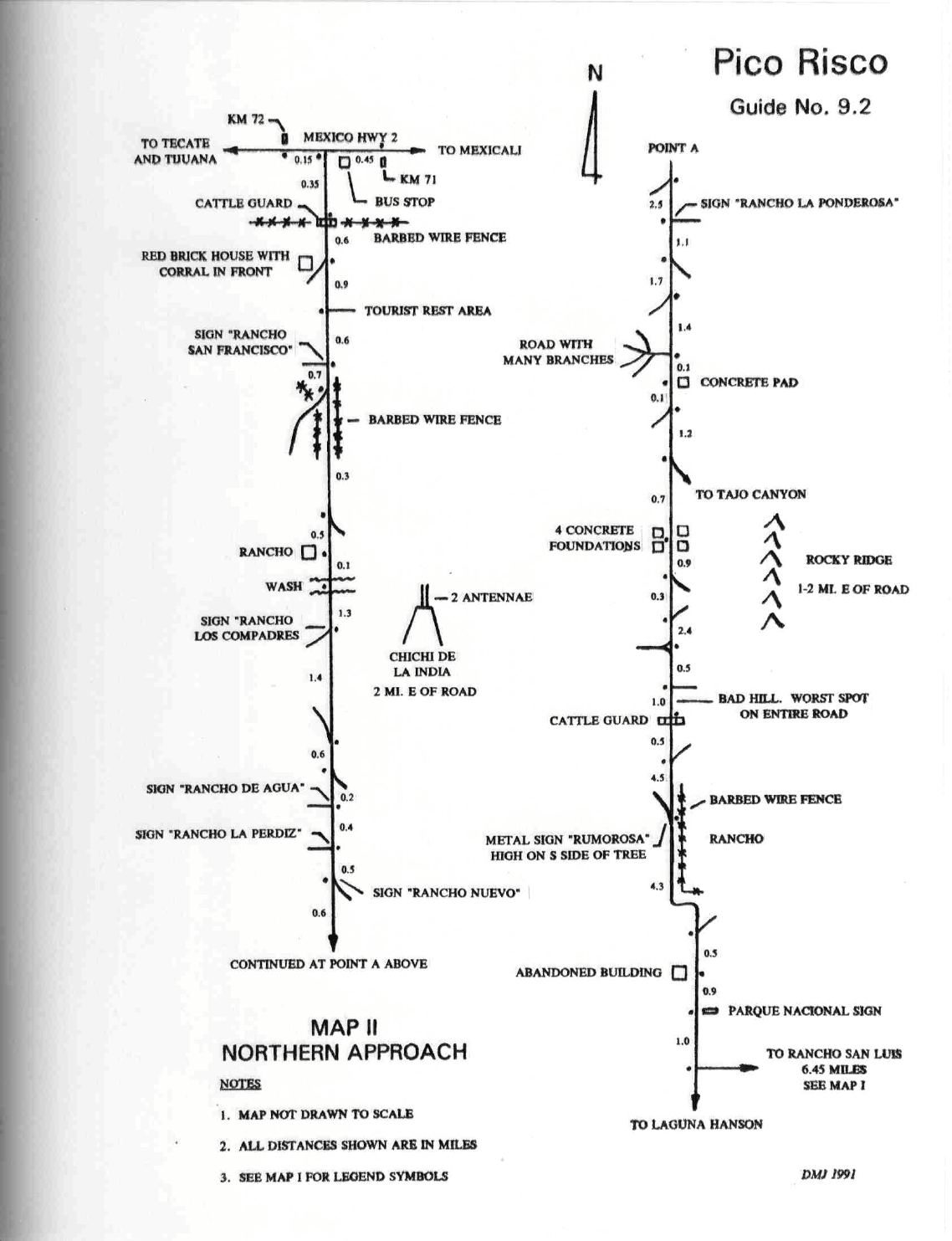
DRIVE/ROUTE A/NORTHERN APPROACH: From the International Border crossing at Tecate, BC drive
S (downhill) to the end of the road at the second stop light. Turn left here and drive E on Mexico Highway 2
about 30 miles to the western outskirts of the town of La Rumorosa. 0.15 miles E of Highway Kilometer post
72 turn right (S) on a dirt road heading toward Parque Nacional Constitucion de 1857. Follow Map II from
here to Rancho San Luis and the start of the hike. Although this approach is more direct than the western
approach through Ojos Negros, it is a more difficult road to follow and can be especially bad or impassable in
wet weather. High clearance 2WD vehicles are adequate under normal (dry) weather conditions. 4WD,
although not necessary, would add a margin of safety for any unforseens encountered on the road. Plan on 2
1/2 to 3 hours of driving time from Mexico Highway 2 at La Rumorosa to Rancho San Luis.
CLIMB/ROUTE A: Since Pico Risco is not visible from Rancho San Luis and the desert terrain between the
two points is somewhat confusing because of its homogeneous (look-alike) nature, it's helpful to have an
intermediate landmark to navigate by on the approach to and return from the peak. So, identify the large rock
peak about 1.0 mile away from the rancho at a bearing of 94°. This important landmark, visible from nearly
all points along the route, will help guide you. With this in mind, hike generally E from the rancho toward the
landmark peak, following a trail that goes downhill past a small wooden house on the right. This trail crosses
a wash about 200 yards after leaving the rancho and becomes more heavily ducked the further you go. When
you get within about 200 yards of the base of the landmark peak, bear left (N), following a fair, ducked trail
about 0.25 miles down a wash and easy terrain to a small saddle. It's at this saddle that Pico Risco comes into
view for the first time. It is easily recognized by its sheer, rocky appearance, light colored banding and summit
ridge which slopes downward and right from the highpoint. Hike NNE from the saddle, following a fair trail a
short distance down to a sand wash. Hike about 0.75 miles NE in this sand wash (ducked) to a fork. Continue
straight at the fork, heading E 0.25 miles, then turn left (NNW) down a sand wash that runs parallel to and just
W of the peak. In 0.3 miles turn right (E), gaining about 500 feet of elevation to the visible saddle south of the
peak. From the saddle turn left (N) and follow the ridgeline until progress is barred by large boulders. Drop
down on the left (W) side of the ridge and follow along the base of the boulders for 25 feet to a large keyhole
through the rocks. Climb through the keyhole to the E side of the ridge then left (N) and up to the ridgeline
again, where you'll encounter a short, narrow section of ridge that could loosely be termed a "knife edge".
PICO RISCO (CONTINUED)
9 MEXICO RANGES GUIDE NO. 9.2
Once across this narrow 12 foot long section, weave through the final boulders to the base of the summit
block. A short, upward sloping step-across of about 2 feet (exposed on the W side) puts you on the slanting
summit boulder, which is climbed to its top. A rope might be welcomed by some climbers negotiating the
step-across, especially on the descent.
ROUND TRIP STATS/ROUTE A: 1200 feet elevation gain, 5.5 miles, 5 hours
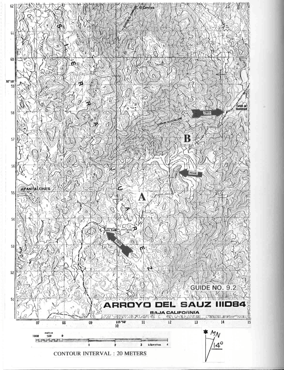
DRIVE/ROUTE B/EASTERN APPROACH: From the border crossing at Mexicali, BC drive SE on Lopez
Mateos Boulevard, following the signs for San Felipe. As a point of reference, Lopez Mateos Boulevard has a
set of train tracks running down the middle of it. 5.0 miles from the border you'll come to a traffic light at the
Sanchez Taboada traffic circle (Pemex gas station and liquor store on the right). Drive into the traffic circle
and bear right at the first major road exiting the circle heading S. In 0.6 miles you'll come to a stop sign at the
junction of Mexico Highways 2 and 5. Turning right (W), drive approximately 22 miles on Highway 2 to a
dirt road turnoff 0.5 miles W of highway kilometer post 27. Turn left (S) here on an excellent dirt road and
drive 27 miles along the W side of Laguna Salada (often dry) to a sign "Canyon de Guadalupe". Turn right
(W) here and drive 7 miles to Guadalupe Hot Springs and Campground, the starting point for the climb of
Pico Risco. This campground is privately owned and charges a small fee for use of the facilities which
includes a hot spring. NOTE: Mexico Highway 2 is being converted into a toll road with a free (libre) road
paralleling it on the south side. The dirt road turnoff to Canyon de Guadalupe can only be accessed from the
free (libre) road, not the toll road. Unfortunately the highway kilometer post markers are located on the N side
of the divided toll road, so finding kilometer post 27 can be a bit difficult. Because of all this construction
there is no guarantee that the current highway turnoff 0.5 miles W of kilometer post 27 will remain viable in
the future.
CLIMB/ROUTE B: Hike SW up Guadalupe Canyon about 0.5 miles, keeping to the right of the creek. At
this point turn S and walk about 0.25 miles to a dry wash, following it SW about 1.0 mile. The peak is easily
recognizable from here as the steep, banded mountain approximately 0.4 miles to the SE. Climb to the saddle
0.2 miles W of the peak, following CLIMB/ROUTE A from there to the summit.
ROUND TRIP STATS/ROUTE B: 3900 feet elevation gain, 5 miles, 8 hours
SIDELINES
1. The International Border crossing stations at Tijuana and Mexicali are open 24 hours a day. Returning to
either of these locations in the late afternoon on almost any Sunday or on the last day of a holiday weekend
will almost certainly mean a long wait at customs. The border crossing at Tecate is usually less congested but
is only open from 6AM to midnight each day.
2. See SIDELINES 4 and 5, Cerro Pescadores, Guide No. 9.1 for important information on Mexican
automobile insurance and gasoline available in Mexico.
3. For those planning on climbing Pico Risco from Rancho San Luis, rest assured that the occupants of the
rancho are a friendly group. As a gesture of appreciation and goodwill for allowing you to use their property
as a starting point for the peak, consider giving them a small donation. They are poor and would be grateful
for any old clothes you could spare, canned food goods, fresh fruit, etc..... Don't be the "ugly" American and
PICO RISCO (CONTINUED)
9 MEXICO RANGES GUIDE NO. 9.2
demand that they open their rancho to you without thought of compensation. That kind of attitude could spoil
it for those that follow.
4. Besides the usual DPS register found on the summit, the Grupo Alpino de Tijuana has also placed a
register there. According to them the peak is named Pico Rasco.
5. The AAA Baja California map (Ensenada inset) and Baja California Guide Book (page 53) are valuable in
helping you find your way through Ensenada to the start of Mexico Highway 3. Described below is a route
that should get you through Ensenada with a minimum of confusion.
Entering Ensenada (from Tijuana) on Mexico Highway 1-D, drive past the port area (on your right coming in)
to a major fork and stop sign at a Pemex gas station. Bear right, following the main road, Lazaro Cardenas
Blvd, as it heads E then SE through an area of restaurants and nightclubs (the harbor is on your right) to its
end in about 1.3 miles. Turn left (E) here onto Calle General Agustin Sangines and drive 0.6 miles to a
stoplight at the Mexico Highway 1 junction. There is a Pemex gas station on the NW corner of this
intersection. Turn left (N), driving about 0.7 miles to a stoplight at the Benito Juarez Monument. Turn right
(E) here on Mexico Highway 3 (called Calzada Cortez) and drive a short distance to where the road forks at a
lumber yard. Bear left, following the road SE as it passes through the run-down outskirts of Ensenada on its
way to Ojos Negros.
6. See SIDELINES 2, El Picacho del Diablo, Guide No. 9.3 for information on tourist card requirements
south of Ensenada.
7. Pico Risco is located within the boundary of a Mexican National Park, Parque Nacional de Constitucion
1857. The same wilderness etiquette that applies to US National Parks also applies here. Minimum impact is
the key.