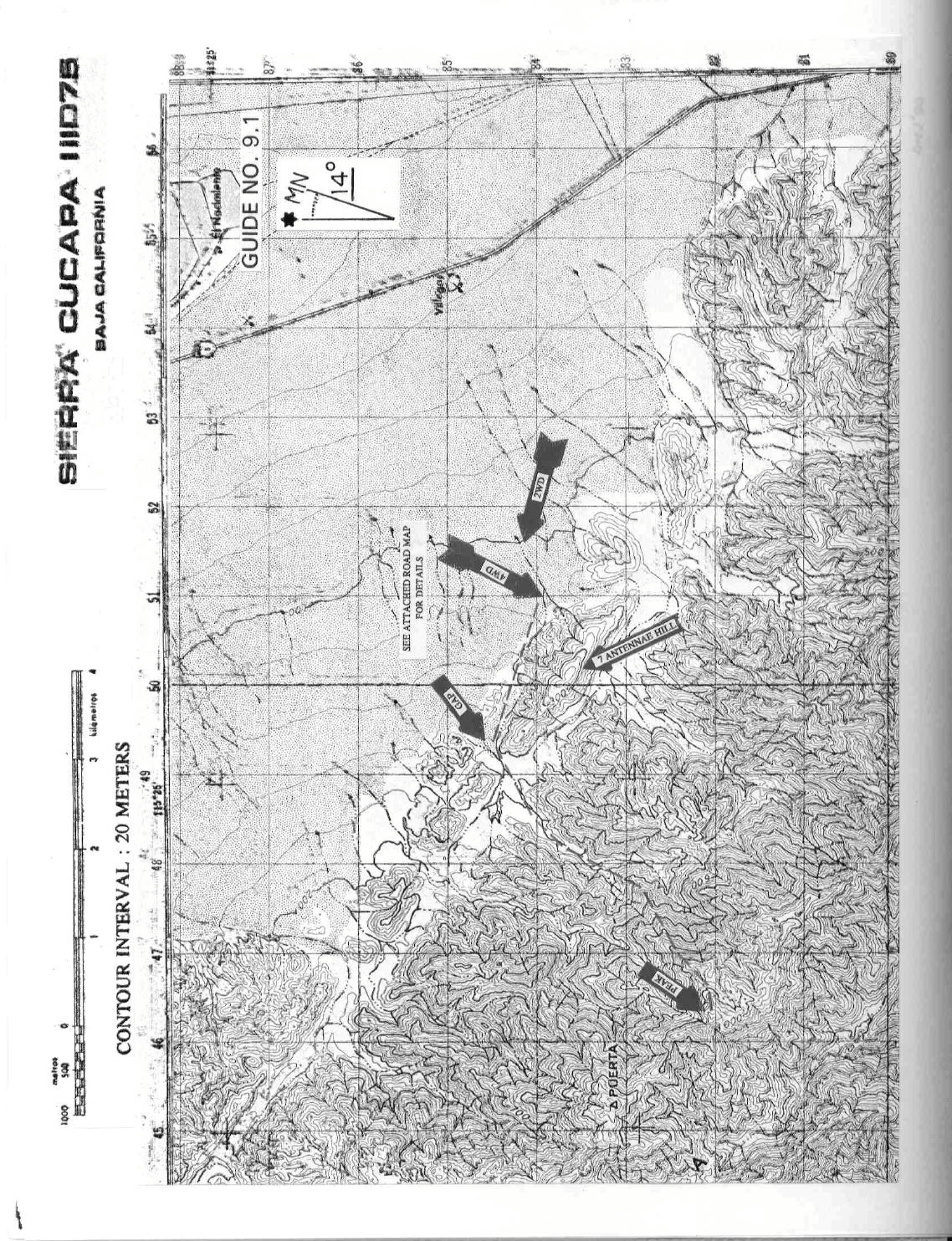
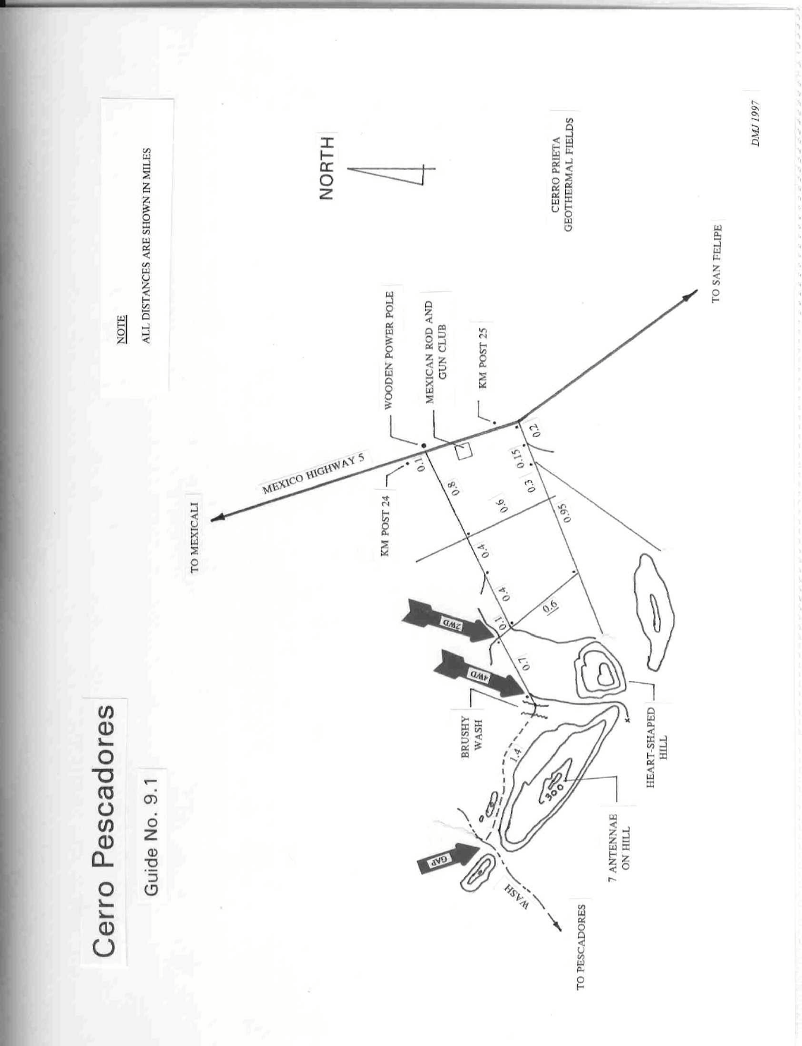
9 MEXICO RANGES GUIDE NO. 9.1
CERRO PESCADORES 3543+ FEET CLASS 2+
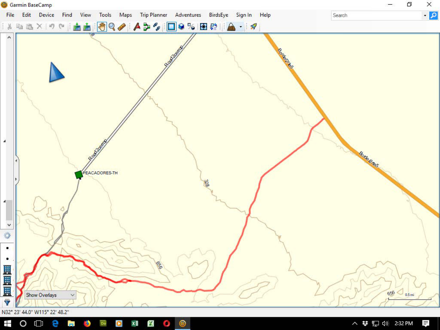
MILEAGE: 270 miles of paved road, 3.5 miles of sandy 4WD road
DRIVE: From the border crossing at Mexicali, drive SE on Lopez Mateos Boulevard, following the signs for
San Felipe. As a point of reference, Lopez Mateos Boulevard has a set of train tracks running down the
middle of it.
5.0 miles from the border you'll come to a traffic light at the Sanchez Taboada traffic circle
(Pemex gas station and liquor store on the right). Drive into the traffic circle and bear right at the first major
road exiting the circle heading S. In 0.6 miles you'll come to a stop sign at the junction of Mexico Highways 2
and 5
Continue S on Highway 5 through the intersection toward San Felipe. Turn right just before kilom
e
ter
post 25, where y
ou’ll find the road
leading west through trash and garbage. The road heads west,
then bears right
behind a line of hills. It can get quite sandy here and 4WD is
required to maintain traction. Park anywhere along here
where you feel comfortable, or go all the way to the end of
the drivable portion where there is an easy turn around
and parking spot.
NOTE: Recent construction on Mex Highway 5 has greatly
altered the previously established dirt road turnoffs
for this peak. There is no guarantee that the current turnoff just N of kilometer post 25 will remain viable in the future.
However, I have driven this road three times in two years and it is likely to remain open, as the tire pit is to the north of
this turn off. Also, the KM markers have changed since the original guide was written. These are current as of 12/28/17.
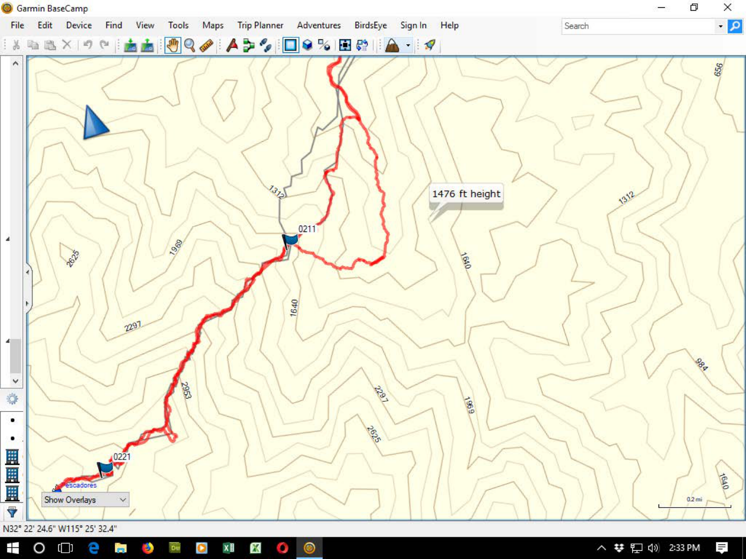
CLIMB:
From the 4WD parking area follow a faint track that heads N through a sandy wash, emerging out
the other side on a hard pack surface. Continue for approximately one mile to the east/west trending wash that
leads to the peak. Drop down into this wash and head west. Standing in this large wash, identify a prominent
gendarm
e (pinnacle) high on a ridge at a bearing of 230°. This is the ridge you'll climb to the summit.
Hike SW up the wash approximately 1.0 mile toward this ridge, en route passing a 30 foot high cliff
along the left margin of the wash. Reaching a fork where a major wash enters from the left, bear left and
follow it about 200 yards to the base of a rocky ridge on the right. Climb SW up this long, rugged ridge by
staying basically on the crest, passing the above-mentioned gendarme on the way. A short distance beyond the
gendarme the ridge will drop 150 feet to a notch. From the notch, bear right and up a scenic gully of decomposing
granite with interestingly weathered patterns (caves, potholes, arches, etc..). Near the top of this gully exit right
and up over rock slabs to a saddle. From here either climb the ridgeline or contour around its left side to the summit,
approximately 0.25 miles to the W.
NOTE: descending this ridge in the dark can be troublesome. There is a good bail off point at a saddle approximately
1600' of elevation at a saddle. The gulley to the south (right hand side on return) that leads down to a sandy wash that
leads back to the fork mention above, right at the ascent point. It's 0.2 miles to the wash from the ridge on fair terrain.
Stay right at the bottom to avoid a spill over, and head left back to the wash you started on. This will avoid the worst
section of the ridge, where the rock is loose and crumbly. (I've done this twice in the dark, and felt it quite safe. -The Editor)
SIDELINES:
1. The border crossing at Mexicali is open 24 hours a day, 7 days a week.
2. Cerro Pescadores translates into Fisherm
an's Peak in English. Either it or benchm
ark Puerta located 1.5
kilometers to the NW is the highpoint of the small, arid Sierra Cucapa range. Both peaks share the same
elevation contour line on the Sierra Cucapa 1:50,000 topo m
ap.

CERRO PESCADORES (CONTINUED)
9 MEXICO RANGES GUIDE NO. 9.1
3. From the summit of Cerro Pescadores you'll have great views W to Laguna Salada and beyond to the rocky
picachos of the Sierra Juarez, including Pico Risco. Looking S on a good day you'll see the high point of
Baja California, El Picacho del Diablo at 10,171 feet above sea level. Visible to the E are plumes
of steam from the Cerro Prieta geothermal resource fields. Hot, pressurized brine from
deep within the earth
is tapped and piped to specially designed tanks that "flash off" high temperature steam
, feeding it to turbines
for the generation of low cost electricity, all at minimal impact to the environment.
4. Traveling into Mexico, be sure to have Mexican automobile insurance before crossing the border.
Insurance is available from any number of vendors at all US border towns. If you do have a claim, be sure to
file it with your authorized Mexican insurance agent before recrossing the border into the United States. And
last of all, always carry your insurance policy with you when you leave your vehicle unattended. If it is stolen
before you return, you'll have a hard time convincing a Mexican agent that you had a valid policy with his
company.
5. Gasoline sold in Mexico is distributed by Pemex, the government-owned petroleum monopoly. Gasoline
is available in two grades at Pemex stations; Nova, the regular grade (80 octane rating, leaded gasoline) which
is dispensed from blue pumps and Magna-Sin, the premium grade (87 octane rating, unleaded gasoline) sold
from silver pumps. Diesel is sold from red colored pumps. Beware that Nova grade gasoline will cause
severe pinging and dieseling in all cars sold in the United States.
6. Although Cerro Pescadores is not located within a Mexican National Park such as Pico Risco, El Picacho
del Diablo and Cerro Pinacate are, please respect this desert wilderness as you would any in the United States.
NOTICE
Problems with drug trafficking along the US-Mexican border have recently given rise to the presence of the
Mexican Army conducting routine patrols in many border areas. Cerro Pescadores is one of the areas targeted
by the Army, with patrols being conducted all around the base of the Sierra Cucapa Range. It would be
prudent not to camp overnight near this peak, but instead to plan on visiting it as a day climb only, being sure
to depart well before dark. There have been reports of climbers being confronted and their vehicles searched
for drugs or weapons by the Mexican Army while attempting to climb the peak, but all reports have indicated
that the Army has done so in a professional manner, without harm to anyone. This notice is to make you
aware of the potential problems in this area and offer suggestions to help you plan your trip accordingly.
Revised 1/1/18
<--End of drivable portion
Deep sand from the
turn to the end.
Turn is just before
KM 25. It is not
marked.
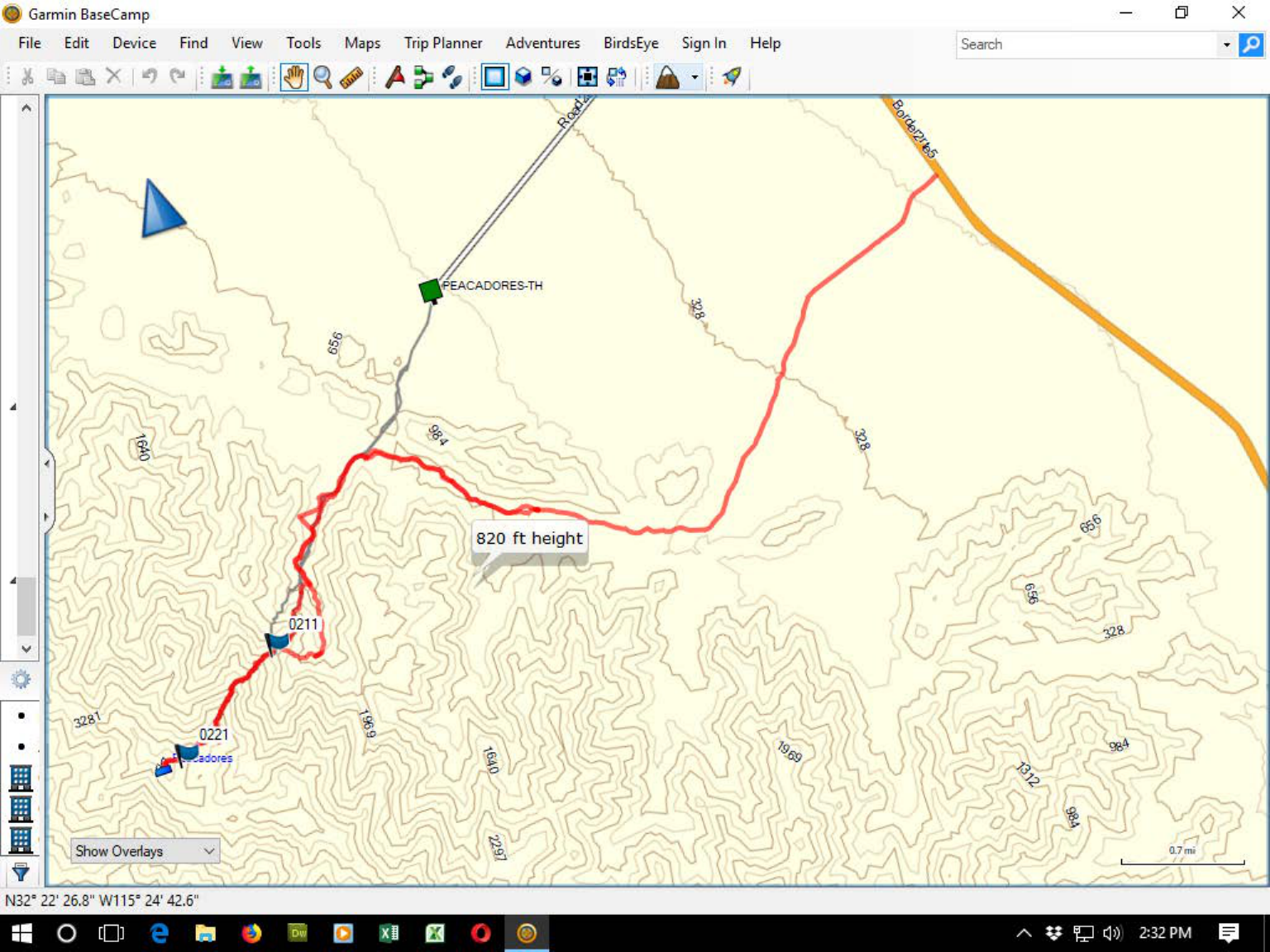
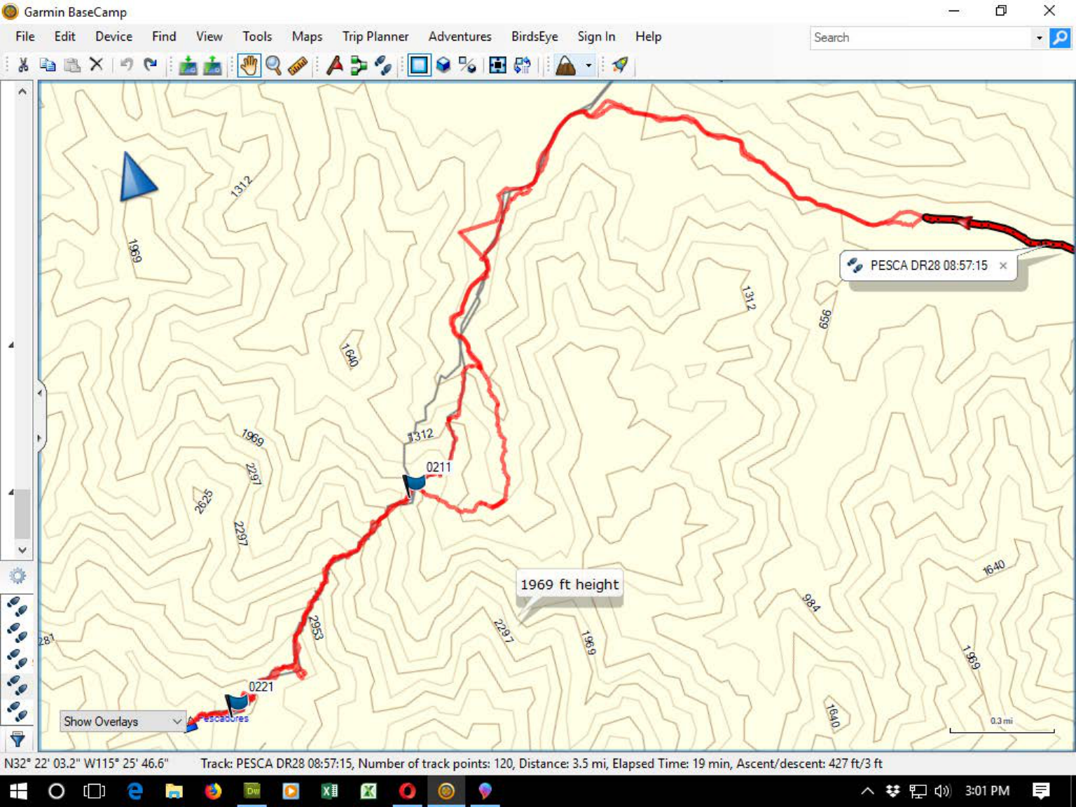
Bail off the ridge here.
Turn right down a steep
but easy gulley to the
wash below. Elevation is
just over 1600'. I made
a way point so I could find
it in the dark.