8 ARIZONA RANGES GUIDE NO. 8.9
BABOQUIVARI PEAK 7734 FEET CLASS 4
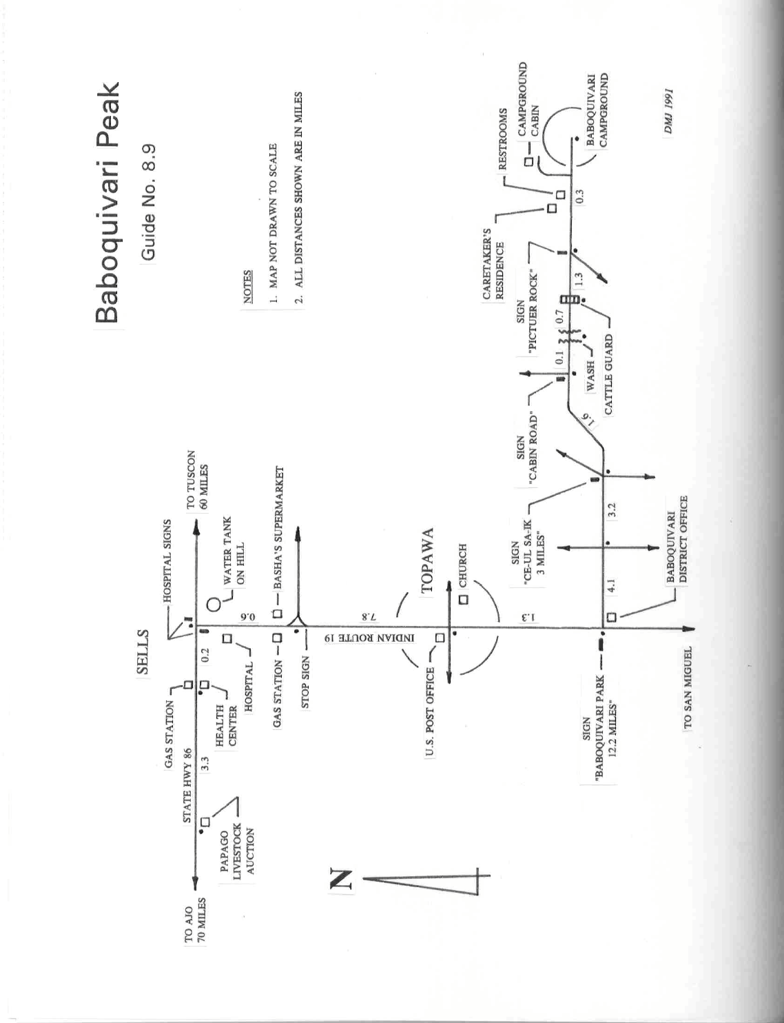
MILEAGE: 490 miles of paved road, 11.3 miles of good dirt road.
DRIVE/ROUTE A: From Ajo, Ariz. drive 70 miles E on State Highway 86 to Sells, Ariz. in the Tohono
O'Odham Indian Reservation.
At 0.4 miles E of highway milepost 113), turn right (S) on a paved road. Drive
0.6 miles to a fork at a sign“Topowa, San Miguel”. Bear right and drive 9.1 miles S through the village of
Topowa to the signed, dirt road turnoff for Baboquivari Park. Turn left (E) here on
a good dirt road and drive
11.3 miles to road's end at the Baboquivari Campground. You need to contact the Baboquivari District Office
at 520-383-2366 before using the campground at the end of this road, but there is not a fee and there may or may
not be a caretaker there. They will send you a pdf form via email, which can be filled out and put on your wind-
shield if you are unable to visit the office.
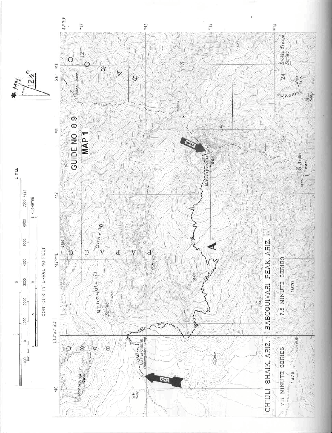
APPROACH/CLIMB A: See Map 1. From the south side of the Baboquivari Campground pick up a distinct
trail heading E toward the mountain. Follow this trail, passing a steel water tank on y
our left and a stone
water tank on your right in the first 0.25 miles and continuing another 200 yards to a junction with a trail
heading right (S). Turn right here, following this trail (shown on the 7.5 minute topo map as a "Pack Trail") S
then E 3.5 miles to its end at the base of cliffs on Baboquivari's W side. Head up and left on a sloping ramp
along the base of these cliffs for a few hundred yards. Picking up the trail above the ramp, follow it through
trees to the base of a 100 foot high 4th class rock wall. At this point the route joins up with the west side
Forbes route (Route B).
CLIMB/ROUTE A: Climb 15 feet up the left side of the wall to a hanger, then diagonally
up and right to a
second hanger 15 feet bey
ond the first one. With a belay from below, anchoring in at these hangers provides
the needed leader protection for this portion of the c
limb, which is the most difficult portion of the wall.
Continue up past one final hanger and 2 steel rods (50 and 65 feet above the base of the wall), then diagonally
right to easier climbing in a 25 foot long chute which leads to level ground at the top of the pitch. A good
belay point at the top is a 4" diameter oak tree, better are two bolted chains to its left.. From here head right
along the base of a cliff to an obvious notch. Passing through the notch, drop down into trees and brush,
following a faint trail to a short crack with a chockstone wedged 7 feet up it. Climb this crack, continuing up
a gully on faint trail to the summit area. The trail becomes quite hard to follow near the summit, so you'll probably
end up doing a little bushwhacking to reach the top. Return the same way, keeping in mind that the 4th class
rock wall you climbed is best descended as a rappel using the chains or the tree as an anchor.
For a small, moderately experienced party, the minim
um group climbing hardware you should have on this
climb is one 9mm (or larger) diameter ropes preferably 60 meters long, four carabiners and two slings of 4
foot long x 1" nylon webbing. In addition, each climber should have his or her own seat harness with either
one locking or two opposing carabiners and a Figure-8 rappel ring. Climbing helmets are also recommended
just as a matter of personal safety.
ROUND TRIP STATS/ROUTE A: 4300 feet elevation gain, 9-10 m
iles, 9 hours
BABOQUIVARI PEAK (CONTINUED)

8 ARIZONA RANGES GUIDE NO. 8.9
DRIVE/ROUTE B: From Robles Jct. at the intersection of Arizona Routes 86 and 286, drive about 29
miles S on 286 to a good dirt road 0.2 mile S of highway milepost 16. Turn right (W), driving through a
gate, then 2.7 miles to a fork. Turn right here, following a fair dirt road N through a wash and then
generally NW 2.85 miles to a second gate. Passing through the gate, drive 1.95 miles on a poor dirt road
(2WD high clearance needed in spots) to a windmill on the left. Continue 0.3 miles to the parking area at
a third gate which marks the boundary of the Baboquivari Peak Ranch. Parking is limited to about about
4 or 5 vehicles.
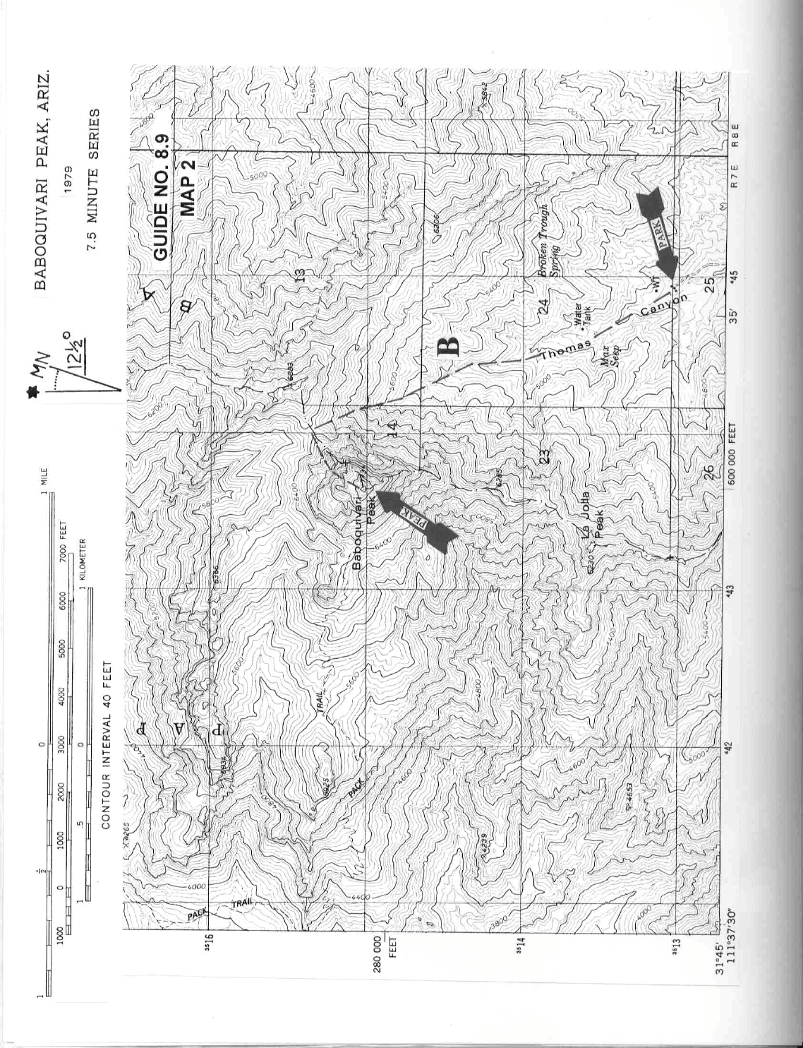
APPROACH/ROUTE B: See Map 2. From the parking spot (elev. 4500 ft.) the im
pressive E face of
Babo is in clear sight. Just to the right of the peak is a prominent saddle you’ll reach by following a well-
worn use trail up the cany
on. Hike up the road beyond the gate to the ranch, skirting right of the main
cabin and passing between a corral and low water tank. Pick up the use trail here and follow it up the
canyon, crossing the creekbed several times. When the canyon begins to steepen, the trail bears right to
gain the ridge above, following it and then contouring W to the abovementioned saddle NE of Babo at
6400 ft. elevation (UTM 440154). From the saddle you’ll see a deep notch to the SW (250° bearing).
Aiming for this notch, pick up a use trail on the W side of the saddle, following it as best you can and
bushwhacking as necessary to the base of a chute below the notch.
CLIMB/ROUTE B: Climb the chute to where it narrows near a large chockstone. Either clim
b 20 feet
directly up and under this chockstone (may be wet), squeezing through an opening, or on the cliff face to
the right of the chockstone to two bolts. A belay anchor can be set up here. Continuing up through the
notch, follow a faint trail along the base of the cliffs to the start of the second pitch. Clim
b about 40 feet
up the steeply sloping face and either continue straight up or bear left up a steep gully to two bolts about
90 feet higher up. From the bolts climb/walk 30 feet up and to the right, picking up a faint use trail along
the base of the cliffs to the start of the third and final pitch at 7400 feet elevation. At this point the route
joins up with the east side route (ROUTE A). Follow Climb/Route A directions from this point to the
summit.
ROUND TRIP STATS/ROUTE B: 3400 feet elevation gain, 9 m
iles, 9 hours.
SIDELINES
1. Permits for camping at the Baboquivari Mountain Park Campground can be obtained by mail or phone in
advance by contacting Baboquivari District Office, PO Box 3001, Sells, AZ 85634 at (520) 383-2366.
Permits can also be obtained on a first come/first serve basis at the campground from the caretaker or at the
Baboquivari District Office, Monday through Friday 8AM-5PM. The District Office is located at the junction
of Indian Route 19 and the Baboquivari Mtn Park dirt road (see map included with this write-up). A permit
is required, but fees are no longer collected. One may call the office and have the form emailed to you
. Fill it
out and leave it on your windshield if you are unable to make it to the office when it is open.
BABOQUIVARI PEAK (CONTINUED)

8 ARIZONA RANGES GUIDE NO. 8.9
The campground has a drinking fountain, flush toilets and running water in the restrooms. Also, a very good,
multi-roomed cabin complete with fireplace is available for overnight use. It's best to reserve it in advance by
phone at the number listed above.
2. During the Depression era of the 1930's, the US government was the single largest employer on the
reservation. It was then that the Civilian Conservation
Corps-Indian Division constructed the road to the
Baboquivari Campground and built the cabin currently standing on the north side of the grounds. The Corps
also constructed the Baboquivari trail and erected a fire lookout tower on the sum
mit. Today the only
reminders left of their work are a few steel supports drilled into the rock face of the 4th class wall and concrete
foundations and piles of wooden boards left on the summit.
3. There is a sacred cave located NNE of the campground. This cave, 850 feet elevation above the
cam
pground, is located at the base of a rock wall at a 28° bearing from the cabin on the N side of the grounds.
The trail leading to the cave starts behind the cabin
and heads E for 300 yards, then turns left (N),
switchbacking up the hill to the cave entrance. The cave itself is about 30'long x 20'wide x 10'high and has a
narrow, slotted entrance approximately 16"high x 30"wide. Inside are a myriad of "offerings" including
Indian baskets and beadwork, money, photos, ID cards, baseball caps, trophies, medals, animal horns and
gourds. Be sure to obtain permission from the resident campground caretaker before setting out to visit this
place; under no circumstances attempt to visit the site without permission from the caretaker. If permission is
granted, respect the sanctity of the cave and do not disturb or remove any of the objects contained therein.
Keep in mind that the entire area around Baboquivari Peak is very special to both the Papagos and some
neighboring tribes such as the Pima. They consider it a sort of giant "spiritual prism" which serves to focus
metaphysical energy in the area.
4. The name Papabotas was given to the Indians living in the Lower Sonoran Desert by
the Spanish in the
16th century. This name evolved into the currently fam
iliar "Papago". Neighboring Indian tribes called them
the Tohono O'Odham, which translates into "Thirsty" or "Desert" People. It is considered the official name of
the tribe.
5. One interpretation of the name origin of Baboquivari is that it’s a corruption of the Papago words vav
kívolik, which literally translated mean “mountain” and “ narrow in the middle” but are generally translated to
mean “a neck between two heads”. As seen from a southern vantage point, the peak supposedly resembles
this latter description. Over the centuries this peak has been known by many different names. The Spanish
missionary Father Eusebio Francisco Kino (1645-1711) called it Noah’s Ark since his party reasoned it
looked like a tall castle resting on the top of a high peak. In the mid- 1800’s it was also known as Papago
Peak and Picacho de Baboquivari by American surveyors working in the area.
6. Baboquivari Peak was first climbed in July 1898 by Dr. Robert Forbes, a professor at the University of
Arizona in Tuscon. He approached the peak from the west side and climbed it via what is now known as the
Forbes route, which is the Route B described in this guide. His accomplishment was quite a daring
8 ARIZONA RANGES GUIDE NO. 8.9
BABOQUIVARI PEAK (CONTINUED)
feat in its day, getting to the summit of this great mountain by a complicated route without use of the climbing
paraphenalia we rely on today as a matter of course.
7. An interesting side trip on the west side of the Baboquivari Mountains can be made to Picture Rock. It’s a
brownish/whitish rock outcropping that gets its name from numerous petroglyphs carved into its SW face.
Located about 1.25 air miles WSW of the Baboquivari Campground at UTM 383157 on the 7.5 minute Chiuli
Shaik, Ariz. 1979 topo map, it is accessible by road to any standard 2WD vehicle. From the Baboquivari
Campground drive 0.3 miles W to a fork. Bear left and drive 0.9 miles to a fork. Bear right and drive 0.3
miles to Picture Rock.
8. The summit of Baboquivari Peak straddles the boundary of the Baboquivari Peak Wilderness and the
Tohono O’Odham
Indian Reservation. The Baboquivari Peak Wilderness, managed by the Bureau of Land
Manageme
nt, encompasses approximately 2,065 acres of land, making it the smallest wilderness area in the
state of Arizona.