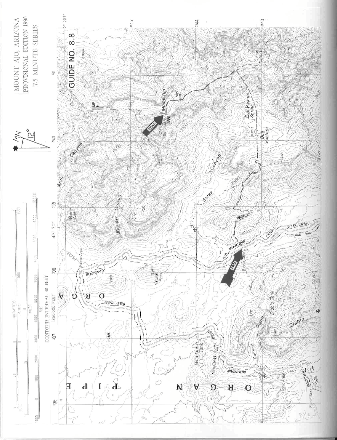
8 ARIZONA RANGES GUIDE NO. 8.8
MOUNT AJO 4808 FEET CLASS 2
MILEAGE: 441 miles of paved road, 10 miles of excellent dirt.
DRIVE: From the town of Ajo, AZ. drive approximately 30 miles S on State Route 85 to the signed "Ajo
Mountain Drive" turnoff. This turnoff is just opposite the entrance to the Organ Pipe National Monument
Visitor Center, where you must first go to pay the park entry fee (This fee allows you entry into and travel
within the Monument for a period of 7 days from the date of issue. You are subject to fine if caught without a
valid fee receipt in your possession while traveling any of the Monument’s back roads. Go approximately 10
miles on the Ajo Mountain Drive Road (excellent dirt; the first 2 miles are 2-way traffic; the balance is a 1-
way loop) to the signed "Estes Canyon-Bull Pasture Trailhead". Park.
CLIMB: The summit of Mount Ajo can be seen at a 58° bearing from the trailhead. Start out by following
the Bull Pasture Trail 1.8 miles E to where it crests out on a ridge near 3200 feet elevation. A backcountry
sign-in box found here should be used to register the group. From the crest, the route through the distant cliffs
can be seen as a chute at a bearing of 83°. The base of this chute can be seen to lie just left of a number of
smooth, weathered pinnacles. To reach the chute, follow the trail downhill and to the right, coming to a small
spring in the ravine below. From here hike cross country in an easterly direction to the base of the chute,
avoiding brush by sidehilling on the right side of a wash as you approach the chute. Entering the chute at any
convenient place, follow it to the base of steep cliffs at its head. Bear left here on easy ground to gain the
summit ridge. Follow the summit ridge 0.75 miles NNW over a few bumps to the top. A faint trail and a
littering of National Park Service boundary markers will be obvious on your way to the highpoint.
ROUND TRIP STATS: 2600 feet elevation gain, 7.5 miles, 6 hours
SIDELINES
1. Mount Ajo is the highpoint of Organ Pipe National Monument and is located within the boundary of the
Organ Pipe Wilderness. This wilderness encompasses approximately 312,600 acres of land and is the third
largest wilderness area in the state of Arizona. It is managed by the Organ Pipe National Monument.
2. From the summit of Mt. Ajo you'll be able to see landmarks at the following bearings: Papago village of
Gu Vo at 73°, Kitt Peak observatory at 93°, Baboquivari Peak at 103°, Lukeville AZ/Sonoita MX at 213°,
Cerro Pinacate at 248°, Kino Peak at 288°, Phelps Dodge's copper tailings pile at Ajo AZ at 338°, and the
town of Why AZ and Montezuma's Head at 348°.
3. See SIDELINES 4, Cerro Pinacate, Guide No. 9.4 for services available in Lukeville, AZ.