8 ARIZONA RANGES GUIDE NO. 8.7
KINO PEAK 3197 FEET CLASS 3
MILEAGE: 414 miles of paved road, 12.3 miles of excellent dirt, 4 miles of poor dirt
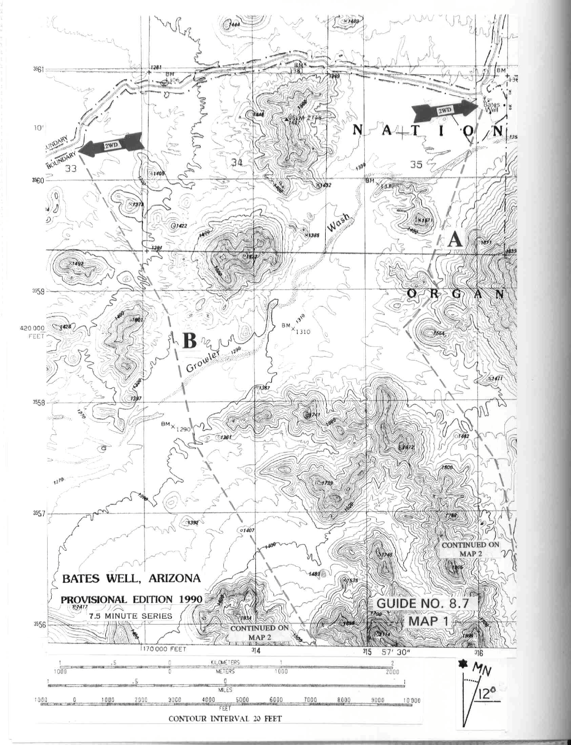
DRIVE/ROUTE A : From the white, Spanish style Catholic church located on the W side of State Route 85
in Ajo, AZ (this church and a Spanish style plaza across the street are located on the S edge of town), drive 2.6
miles S on State Route 85 to the signed Darby Wells Road. Turn right here on excellent dirt, following it 1.8
miles to a fork. Bearing left onto the Bates Well Road,
continue on good but washboarded road to a cattle guard
and enter Organ Pipe National Monum
ent. There is a parking area here with a self pay kiosk. Pay your park fee here, or
if you have a park pass, fill out the envelope, including your pass number. Continue straight 4.0 miles on a dirt road to
the signed Bates Well turnoff. Make a left turn into the parking area adjacent to a small cabin. Park here.
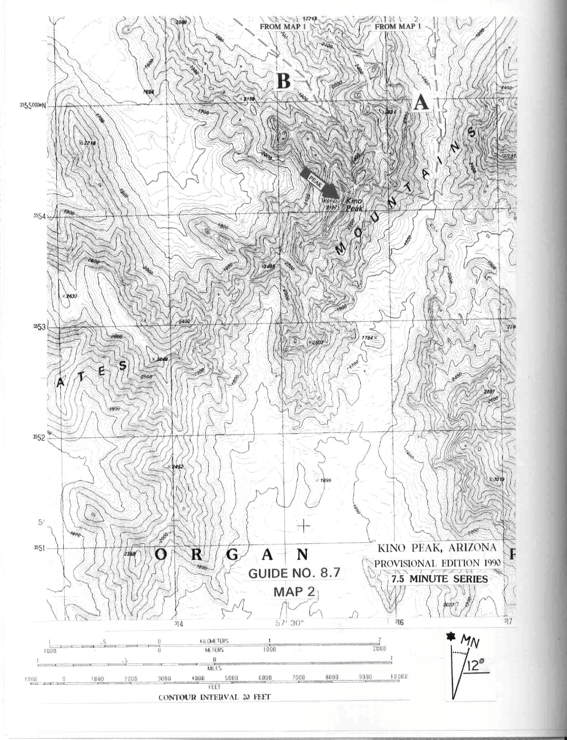
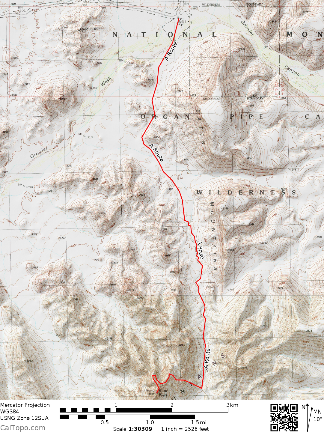
CLIMB/ROUTE A: From the parking area, head 0.5 miles S across brushy terrain to Growler Wash, a large
sand wash running basically E-W across your path. Continue SSW across the wash, hiking to the shallow
saddle at UTM 156590. From the saddle hike SW around the W side of hill 1554. At this point you should
be able to pick up a faint trail heading generally S up the canyon. Don't despair if you can't easily find it; the
trail is quite faint in this area. Follow the trail S up the canyon, staying generally on the W side of the wash.
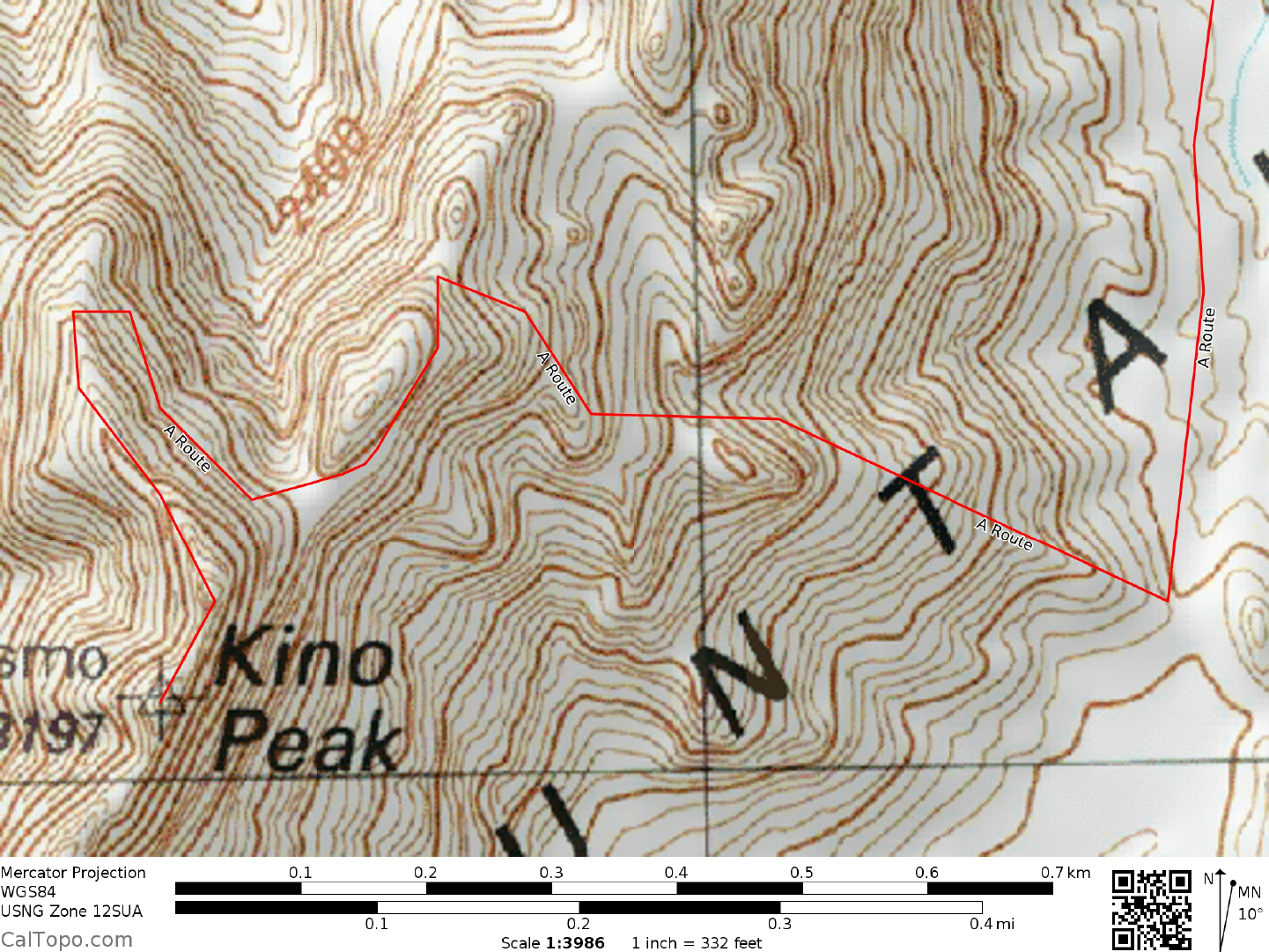
In about 3.0 miles the trail will reach a broad saddle at 1800 feet elevation, 0.5 miles E of the peak (From this
saddle the summit of Kino and its sheer E face are clearly visible at a 278° bearing). From the saddle identify
a prominent pinnacle at bearing 296° and hike up the ridge to it, passing below its base on the right side and
climbing back to the ridgeline just beyond the pinnacle. Continue upward to nearly the crest of the summit
ridge, then traverse left (S) to the edge of a deep chute. With a little searching you’ll find a steep but easy
ledge that can be followed down into the chute. Traverse the chute and enter a second chute immediately to
the south. Climb this second chute to within 15 feet of its top, where progress is barred by a rock wall. Climb
a break in the wall along its right margin, heading up and left about 50 feet to a large notch between Kino
Peak and its lower northern neighbor. From this notch head SW, following a faint, ducked trail up the
impossible looking sheer N face of Kino Peak. The route snakes its way up the face and intersects the summit
ridge N of the highpoint. From there its a matter of walking the easy ridge in a southerly direction to the top.
The true summit is a small, unimpressive rock outcropping and not the precipitous peak at the end of the
summit ridge.
ROUND TRIP STATS/ROUTE A: 2000 feet elevation gain, 10 miles, 8-9 hours
DRIVE/ROUTE B: Follow the driving instructions for
ROUTE A
to the Bates Well turnoff. Instead of
turning left into the parking area, continue along the fair dirt road 2.0 miles to a fork where desert vegetation is
growing across the left branching road. Park.
CLIMB/ROUTE B: Hike along the poor, left branching dirt road about 0.75 miles to where you can clearly
see Kino Peak off to the southeast. Hike towards the peak, heading around the left (E) side
of point
1601, then
SE at a 144° bearing to the canyon W of point 1856. Hiking up this canyon, keep to the
KINO PEAK (CONTINUED)
8 ARIZONA RANGES GUIDE NO. 8.7
right to gain the obvious U-notch just N of Kino Peak (Don't be tempted to go left up the canyon with the
clearly visible keyhole in the rock.). Once at the U-notch, follow the faint trail described in ROUTE A up the
sheer N face of Kino to the summit ridge and the top.
ROUND TRIP STATS/ROUTE B: 2100 feet elevation gain, 9 miles, 8-9 hours
SIDELINES
1. Kino Peak lies within the boundary of the Organ Pipe Wilderness. This wilderness encompasses
approxim
ately 312,600 acres of land and is the third largest wilderness area in the state of Arizona. It is
managed by the Organ Pipe National Monument.
2. Organ Pipe National Monument has an entrance fee requirement. Driving to Bates Well along the Darby
Wells Road, y
ou won't pass an entrance station where fees are
collected, but that does not relieve you of the
responsibility for paying the entry fee. Assuming that no one will be at Bates Well to collect the money, you
will have to drive to the Visitor Center in the Monument (30 miles S of Ajo on State Route 85) to pay for and
obtain the standard 7-day permit required for entry into and travel within the Monument. A hefty per vehicle
fine can be levied by the ranger if you are found without a permit inside the Monument. If you're planning on
a climb of Ajo Mountain along with Kino, save yourself a lot of extra driving and maybe a fine by doing Ajo
first; the dirt road turnoff for Ajo Mountain is directly across State Route 85 from the Visitors Center. As an
alternative, you can obtain a permit in advance by mailing your itinerary, check made payable to the National
Park Service, and a SASE to:
Organ Pipe Cactus National Monument
Route 1, Box 100
Ajo, Arizona 85321
Attn: Fee Supervisor
To get current fee information call the Monument headquarters at (520) 387-6849
3. Kino Peak is named in honor of Father Eusebio Francisco Kino (1645-1711). Father Kino, born in Italy
and educated in Germ
any,
was the leader of the Jesuit missionary effort in the area during the late 1600's and
early 1700's.
4. Overnight camping in the Monument is available at the m
ain cam
pground adjacent to the Visitor Center on
a first-come, first-served basis. Facilities at this fee campground include restrooms and drinking water. The
individual camp sites have tables and fire pits. Private campgrounds are located in Lukeville (see Cerro
Pinacate, Guide No. 9.4, Sidelines 3) and Why, AZ. Primitive camping is available at backcountry
campgrounds, however a permit for such camping must be obtained from the Park Ranger at the Visitor
Center.
Revised 2/6/18