8 ARIZONA RANGES GUIDE NO. 8.4
WEAVERS NEEDLE 4553 FEET CLASS 4
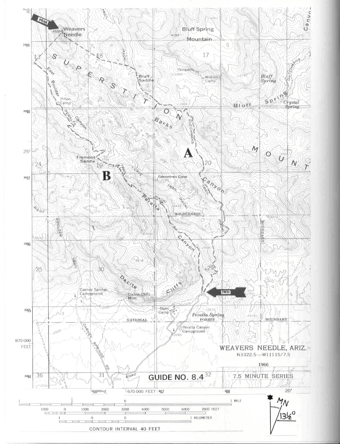
MILEAGE: 412 miles of paved road, 7 miles of excellent dirt
DRIVE/ROUTE A: From Phoenix, AZ drive about 27 miles E on US Highway 60 (Superstition Freeway
) to
the end of the freeway. Continue another 4.5 miles SE on US Highway 60 to the signed Peralta Road at
highway milepost 204. Turn left (NE) and drive 5.6 miles of excellent dirt to a fork. Bearing left here (right
will take you to the Quarter Circle U Ranch) on the Peralta Road, drive 0.6 miles to a fork. Bearing right (left
will take you up the unsigned Carney Springs Road to the trailhead for ROUTE B on Superstition Mountain),
drive 0.9 miles to the end of the road at a parking lot with restrooms. Park.
CLIMB/ROUTE A: Two trails have their beginning at the
N end of the parking lot. Choose the trail on the
right, hiking about 50 y
ards to the signed junction of the Bluff Springs Trail and the Dutchmans Trail. It's a bit
confusing here if you're reading the map because the signed Bluff Springs Trail is actually called the
Dutchmans Pack Trail on the 7.5 minute topo and the signed Dutchmans Trail is identified as the Miners
Needle Trail on the same map. Disregarding this discrepancy, bear left on the signed Bluff Springs Trail and
follow it 3 miles N to a junction with the Terrapin Trail (called the Needle Pack Trail on the 7.5 minute topo!).
Turn left (NW) on the Terrapin Trail and hike 0.75 miles to Bluff Saddle (shown as such on the topo).
Continue down over the saddle about 0.2 miles and leave the trail, heading 0.25 miles NW to a low saddle.
Continuing in the same direction, cross-country through brushy terrain toward Weavers Needle, climbing a
slope to the base of the sheer E face. This will place you at the bottom of a very steep chute which emanates
from the V-notch, a deep gash that separates Weavers Needle from its southern neighbor.
The real climbing is about to begin, so now's the time to get into y
our seat harness and don a climbing helmet.
A word of warning here; the rock above is loose and could pose a threat to your safety if other parties are
climbing above you in the chute. It would be prudent to back away a short distance from the face and let them
reach the V-notch before starting up this first pitch. See SIDELINES for recommendations on both group and
individual climbing equipment needed on this route. For the first (and crux) pitch on the needle, climb rock
along the far right side of the chute for about 70 feet to where you can angle up and left into the main part of
the chute. There are few good spots for placing protection along this first pitch, however somewhat above the
pitch you'll find a sturdy rock for setting up a belay anchor. Climbing directly up the chute, you'll encounter
2 short (8-10 foot) Class 4 pitches before reaching the V-notch. From the notch an
awkward Class 3 to 4
move of about 15 feet up and to the right will lead to easier ground above, where you'll climb about 250 feet of
Class 2 rock. A 50 foot section of Class 3 to 4 rock above this leads to Class 2 slopes just below the top. One
final, short wall of Class 3 will bring you to the summit. Descend the same way. There is a pair of chains bolted
to a wall to the right of where one exits the 50 foot section of Class 3 to 4 rock. These chains may be used as an
anchor to rappel off the edge of the ledge, bypassing a potentially difficult down
climb on that 50 foot section of rock wall. It is over hung, so be prepared to come free from the wall about 20
feet from the bottom.
ROUND TRIP STATS/ROUTE A: 2300 feet elevation gain, 10 miles, 10-12 hours
DRIVE/ROUTE B: Same as DRIVE/ROUTE A driving directions.
WEAVERS NEEDLE (CONTINUED)
8 ARIZONA RANGES GUIDE NO. 8.4
CLIMB/ROUTE B: At the N end of the parking lot choose the left trail (Peralta Trail), hiking NW up Peralta
Canyon about 2.5 miles to Fremont Saddle at 3766 feet elevation. Continue over the saddle into East Boulder
Canyon about 2 miles to a point SW of the needle. Drop down and cross a creek bed, heading NE on a steep,
faint use trail until progress is stopped at the base of the Needle by a smooth rock wall. Scramble up the right
side of the wall on a 20 foot pitch of Class 3 rock to the base of a chute that terminates high above at a V-
notch. This location is identified by a steel stake driven into the rock about 15 or 20 feet above. The real
climbing starts here.. Climb a 165 foot pitch of mixed Class 3, 4, and 5.3/5.4 rock directly above. At the top
of this long pitch is a huge, difficult chockstone which can be bypassed on the right by taking a very short
Class 5.6 pitch to the V-notch, where one joins up with ROUTE A. This detour around the chockstone can be
protected by a second steel stake lower down and/or by slinging a smaller chockstone just below the large one.
The two steel stakes, small chockstone and a few mid sized camming devices provides the necessary leader
protection to negotiate this pitch. From here follow CLIMB/ROUTE A to the top. This route is more
technically difficult than ROUTE A but is safer from the standpoint of rockfall, which can be horrendous on
ROUTE A. The descent of ROUTE B from the V-notch will require a long rappel.
ROUND TRIP STATS/ROUTE B: 3300 feet elevation gain, 10 miles, 10-12 hours
SIDELINES
1. Route A climbers should consider the following group
equipment
as a minimum: 9 one mm (or larger) x
60 meter long climbing ropes, four slings of 12 foot long x 1" nylon webbing and 3 carabiners. In addition,
each climber should have a seat harness with either one locking or two opposing carabiners, a Figure-8 rappel
ring and a climbing helmet.
2. Free overnight car camping is available just down the road from
the Peralta and Bluff Springs
trailhead
parking lot at the Peralta Canyon Campground. This is a primitive camp area without tables, toilets or
services of any kind.
3. The early Spaniards who ventured into the Superstitions called the range Sierra de la
Espuma
which,
translated into English means "mountains of foam". They probably got this name from an old Pima Indian
legend that spoke of a great flood across the land, the foam of which caused the broad white streaks in the
limestone cliff faces of the range. The current name of the range is most likely attributed to local stories of the
malevolent nature of these mountains. There was some basis for these stories since Apaches were known to
lie in wait along the principal routes throughout the range, hoping to ambush unwary travelers. In fact, the US
Cavalry was ordered into these mountains many times during the late 1800's to ferret out renegade Apaches.
4. Local lore suggests that Weavers Needle was possibly
name
d for the scout Pauline Weaver. Others say the
peak got its name because of a resemblance to the needle used by weavers.
5. Weavers Needle plays a part in the mystique of the Lost Dutchman Mine. A legend has it that the needle
is a critical landmark for locating the mine. It is said that at a particular time and day of the year the needle
WEAVERS NEEDLE (CONTINUED)
8 ARIZONA RANGES GUIDE NO. 8.4
casts a shadow on the entrance to the lost mine. Sounds like something right out of "Indiana Jones and the
Temple of Doom".
6. Weavers Needle lies within the boundary of the Superstition Wilderness Area. This
wilderness
area
encompasses approximately 159,780 acres of land and is managed by the Tonto National Forest.