8 ARIZONA RANGES GUIDE NO. 8.3
SUPERSTITION MOUNTAIN 5057 FEET CLASS 2
MILEAGE: 412 miles of paved road
DRIVE/ROUTE A: From Phoenix, AZ drive about 27 miles E on US Highway 60 (Superstition Freeway
) to
the end of the freeway. Continue about 3 miles E on US Highway 60, now a two lane divided highway to the
signed turnoff for King Ranch Road. This turnoff is located 0.3 miles W of highway milepost marker 203.
Turn left (N) here and drive 2.9 miles to a cattle guard. Just past the cattle guard turn right on signed Baseline
Avenue and drive 0.2 miles to a stop sign. Turn left here on signed Mohican Road and go 0.4 miles to signed
Valley View Drive. Turn left on Valley View Drive, following it past a low stone wall on your left and
passing over a cattle guard (road name changes to Whitetail Road here). At the end of Whitetail Road turn
right on Cloudview Road and drive 0.5 miles on
paved road to road's end at a parking lot. Park.
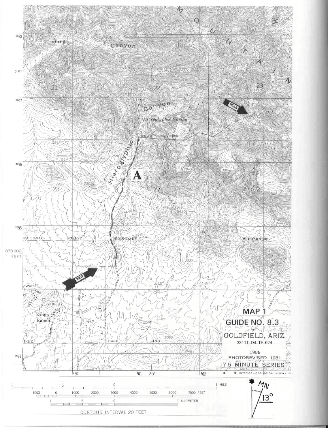
CLIMB/ROUTE A: See Map 1. From
the turnaround walk 0.25 miles E on a well ducked path to a wide trail
running N-S. Turning left (N) here, hike about
1.0 mile to the mouth of Hieroglyphic Canyon, then another
0.5 miles into the canyon on a narrow trail to an Indian petroglyph site. 50 yards before or S of the
petroglyphs, look right (E) up to a ridge with an obvious balancing rock high on it. Climbing up the shallow
canyon just S of this ridge, ascend it to about 3800 feet elevation, gaining the ridge line. From here climb
generally E (faint use trail visible along some stretches of the ridge) over point 4402 and then on to the
summit. Between point 4402 and the top you'll encounter one short (20 foot) pitch of Class 3 climbing to
overcome a rock band across the ridge.
ROUND TRIP STATS/ROUTE A: 3000 feet elevation gain, 6.5 miles, 6 hours
DRIVE/ROUTE B: Follow DRIVE/ROUTE A directions from
Phoenix to the signed turnoff for Kings
Ranch
Road. Instead of turning left here, continue E on US Highway 60 another 1.6 miles to the signed
Peralta Road at highway milepost marker 204. Turn left (NE), driving 5.6 miles on excellent dirt to a fork.
Bearing left here (right will take you to the Quarter Circle U Ranch) on the Peralta Road, drive 0.6 miles to a pull-out
on your left. Park. This is where the Carney Springs road used to be. The road is now closed and the hike is approx-
imately 1.5 miles longer. Note: camping is prohibited, both here, and at the Peralta Trail Head.
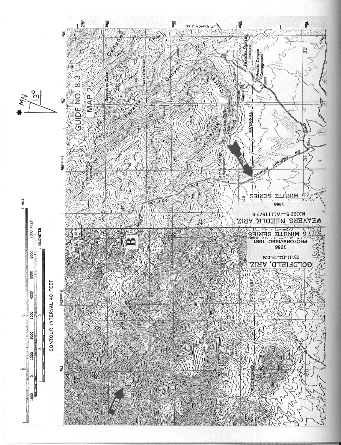
CLIMB/ROUTE
B: See Map 2. Starting at the pull-out, hike up the closed road approximately 0.6 miles to the wilderness
boundary. Pass through the gated fence and hike N up the West Boulder Trail about
1.25 m
iles to a saddle at 3680+ feet elevation. Turn left at the signed intersection, following a well cairned trail (the
Superstition Ridge Trail, faint at times)
to the base of the summit block. There will be a faint fork with the right fork continuing
north past the peak. Take the left fork, which will continue around to the west side of the peak. Climb easy Class 3 rock to
the summit.
SUPERSTITION MOUNTAIN (CONTINUED)
8 ARIZONA RANGES GUIDE NO. 8.3
ROUND TRIP STATS/ROUTE B: 3300 feet elevation gain, 7 miles, 7 hours
SIDELINES
1. If you're doing Superstition Mountain by ROUTE A, plan on spending som
e tim
e at the Indian petroglyph
site in Hieroglyphic Canyon. Even if you're not doing it by ROUTE A, the trip to these petroglyphs is well
worth the visit. The dark rock walls on both sides of the narrow wash are covered with over two hundred
images. Some are easily recognized as snakes, men and bighorn sheep. Others are more difficult to visualize,
providing hours of exercise for the imagination.
2. Perhaps the most famous tale associated with the Superstition Mountains is the story of the Lost
Dutchman Mine. As the legend goes, a young Mexican man, fleeing from his sweetheart's irate father hid in
the Superstitions and chanced upon an incredible deposit of gold. Knowing that the United States was about
to conclude the Gadsden Purchase with Mexico for the sale of great tracts of southwestern lands which
included the Superstition Mountains, he hurried back to Mexico to tell his family of the fabulous find and
encouraged them to travel north to take advantage of it before it became part of the United States. He is said to
have led his family and friends back to the site where they all gathered great quantities of gold for the trip back
to Mexico. But, as fate would have it, the party was ambushed by Apaches and all were killed, except for two
small boys who managed to escape. Retaining the secret of the mine for many years, these survivors
journeyed back to the Superstitions in 1870 to search for their treasure. Here they met an old Dutchman,
making the fatal mistake of telling him about the gold. After extracting the necessary details from the two
men, the Dutchman is reported to have killed them, thus becoming the only person to know the whereabouts
of the riches. From then until his death in 1884, many people tried to follow him to his mine, but none
succeeded in finding the secret spot. Rumor has it that at least eight people were killed by the Dutchman
when he discovered them following him to the mine. On his deathbed he supposedly told a neighbor where
the gold was hidden. The neighbor was unable to find the gold from those directions and gave up, thus
starting the legend of the Lost Dutchman Mine.
3. Superstition Mountain lies within the boundary of the Superstition Wilderness Area. This wilderness
area
encomp
asses approximately 159,780 acres of land and is managed by the Tonto National Forest.
4. Camping is now forbidden at both trail heads. The Lost Dutchman State Park is the closest legal camping.
http://azstateparks.com/Parks/LODU/facilities.html