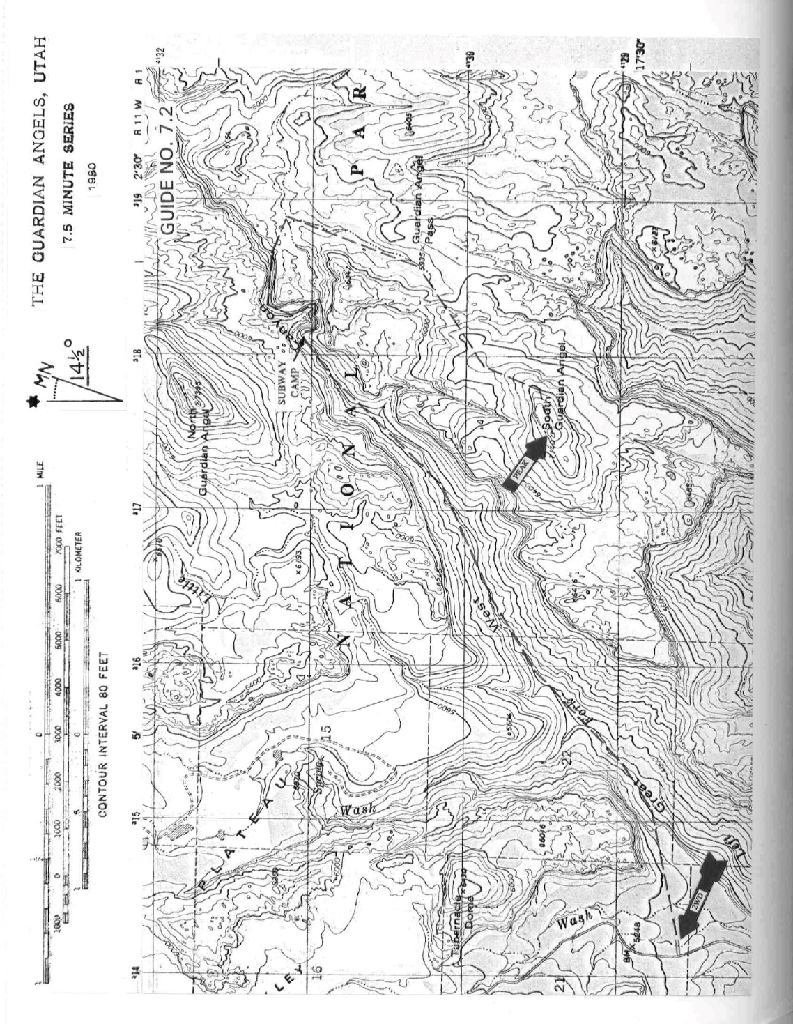
7 UTAH RANGES GUIDE NO. 7.2
SOUTH GUARDIAN ANGEL 7140 FEET CLASS 4
MILEAGE: 450 miles of paved road
DRIVE: From St. George, UT. drive about 7 miles N on Interstate 15 to signed Exit 16 "State Route 9,
Hurricane, Zion National Park". Drive E on State Route 9 about 20 miles through Hurricane and La Verkin
to the small town of Virgin. Turn left (N) here on the signed, paved Kolob Reservoir Road, driving 6.5
miles to the signed boundary of Zion National Park. Continue another 1.6 miles, turning right into a large,
unsigned parking area. This is the trailhead for the Great West Canyon route to "The Subway".
INTRODUCTION TO CLIMB: The South Guardian Angel is one of the most demanding climbs described
in this guide. To attain its summit the climber will be put through an obstacle course which includes route
finding, 4th class rock climbing and wading through water anywhere from ankle deep to chest high or more.
Because of the distances to be traveled and the terrain to be traversed, the South Guardian Angel is best
done as a 2 day backpack trip. The following write-up is based on a 2 day trip with an option to extend it
into a third day. Nearly everyone who has climbed the South Guardian Angel agrees that its one of the best
DPS peaks and certainly among the most memorable experiences they ever had on a "desert" peak.
CLIMB/DAY 1: From the parking lot follow a good trail about 0.5 miles E to the rim of the Great West
Canyon. Follow the trail down a steep slope to the canyon bottom at a flowing creek. Hike NE up the
canyon on a primitive foot path for 3 miles to its end at camping sites just below "The Subway" (UTM
181311), a spectacular narrowing of the canyon bored out by the force of water over countless centuries.
En route to The Subway the trail crosses the creek a number of times and becomes somewhat faint in places,
so "miniroutefinding" will be required to weave through brush, boulders and trees. Good camping sites can
be found at trail's end along the right side of the creek or on a high ledge overlooking these sites just 50
yards upstream. Establish camp here.
After setting up camp, plan on hiking into The Subway and beyond to fix ropes for the next day's climb of
the peak. To accomplish this it's best to change into shorts or a bathing suit and sneakers for the wet work
ahead. Starting out from camp, hike up The Subway to where progress is barred by deep pools and high
walls. Climb the right canyon wall up a rather smooth 30 foot sloping rock face to a wide ledge. The
hardest part of this pitch is at the beginning, where you'll leave the creek and climb a smooth, near vertical
7 foot section. One of two hangers bolted to the rock here is ideal for clipping into with a carabiner attached
to a 5-step etrier. Above this spot it's a friction climb of about 20 feet to the wide ledge and two more
hangers. Leave a rope fixed from one of these upper hangers. Follow the ledge up canyon to easy walking,
more creek crossing and the next obstacle, a deep pool followed by narrows and a waterfall. The deep pool,
entered from the right side of the creek, is usually about 4 to 5 feet deep and is either waded or swum to its
upstream side at the beginning of a tight narrows. This narrows has smooth water carved walls, a deep cut
water groove along its floor and a waterfall at its upper end. Wading into the pool at the base of this
waterfall, you'll probably be standing in 3 to 4 feet of water. Have a companion stand on your shoulders
and either climb through the "eye" to the right of the falls or directly over the boulder above the falls. An
option here would be to throw a rope through the "eye" in
7 UTAH RANGES GUIDE NO. 7.2
SOUTH GUARDIAN ANGEL (CONTINUED)
hopes of having the water sweep the free end of the line down over the waterfall and into your hands, thus
giving you a means of hauling yourself up into the "eye". Once you've conquered the falls, look for a hanger
on the smooth rock about 6 feet above its lip. Clip a carabiner in here and attach a 5-step etrier hung from
a 6 foot sling to get your group quickly past the waterfall tomorrow. Continue hiking up the canyon to a
pool too deep to wade at the mouth of the next narrows. Leave the creek here by climbing 40 feet up the
steep right wall of the canyon to some trees and a dirt ledge. A tree on the ledge makes for a good belay
anchor on the ascent and a rappel anchor on the descent. Leave a rope in place here for tomorrow. Follow
the ledge and a faint trail up canyon to the next barrier, the Slime Traverse, a narrow 40 foot long ledge
about 30 feet above the creek and directly under an overhanging rock wall, forcing most climbers into a
"hands and knees" crawl. A seep from the overhang makes it slippery in spots, so you might consider a
fixed line here to speed things up. Unfortunately, the only anchor points for a rope are trees on either end
of the traverse, and they are about 200 feet apart. If you have that much rope available, set a taut hand line
here and leave it for tomorrow. Less than 100 feet beyond the upper part of the Slime Traverse you'll leave
the canyon for the high plateau above. Climb the right canyon wall up dirt slopes and rock for 60 feet to a
pine tree that can be used as a belay anchor on both ascent and descent. Set a rope here to speed up the
climbing over a short rock pitch midway between the canyon bottom and the pine tree. Having completed
this last step, return to camp at The Subway.
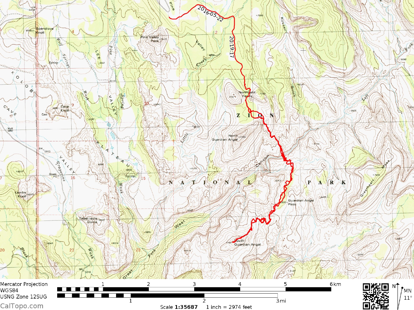
CLIMB/DAY 2: Repeat yesterday's course past each barrier to the upstream side of the Slime Traverse and
beyond to the top of the rock pitch on the canyon's right wall. From here climb brushy dirt slopes to a wall
with a loose, 30 foot high chute on its right side. Climb to the top of the chute, picking up a faint trail which
is followed to the high plateau about 400 feet above the canyon bottom. On the plateau you'll have good
views across the canyon to the North Guardian Angel. The South Guardian Angel is not visible from here,
being hidden by the reddish bulk of point 6347. Hike 100 yards SE, intercepting a sandy wash that is
followed E then SSW for about 1.0 mile (bypassing brushy parts of the wash where necessary by leaving
and re-entering it) to an area of deep red sandstone slabs. Head SW over vividly colored rock slopes and
past weathered rock towers (hoodoos) to the NE ridge of the Angel. Friction walk up the ridge to the
summit area, where one last obstacle remains to be overcome, a moderately angled face with exposure
down the left (S) side. A pine tree at the beginning of this face and stout brush just below the summit are
suitable anchors for rigging a fixed line (45 meter rope needed) to safely and quickly negotiate this pitch.
After a much deserved rest on the top, return to camp via the same route. Plan on either spending a second
night at The Subway camp or packing up and hiking out, remembering that it will take about 2 to 3 hours
to reach the cars.
ROUND TRIP STATS/BACKPACK ONLY: 1300 feet elevation gain, 6 miles, 5-6 hours
ROUND TRIP STATS/CLIMB ONLY: 1900 feet elevation gain, 5 miles, 8 hours **
ROUND TRIP STATS/TOTAL: 3200 feet elevation gain, 11 miles, 2-3 days
** These hours do not include the rope set-up time described in CLIMB/DAY 1

7 UTAH RANGES GUIDE NO. 7.2
SOUTH GUARDIAN ANGEL (CONTINUED)
SIDELINES
1. A Backcountry Permit is required for overnight camping at The Subway. Permits are available in
person only at the main Visitors Center from 8AM-5PM MST daily (except winter). Permit limit is 12
people and vehicle license numbers are frequently required at time of issuance. Permits may be available
during extended hours, but one should phone the Visitors Center at (801) 772-3256 in advance to confirm
availability. Campfires and pets are prohibited in the backcountry. The Lava Point Ranger Station (manned
June through September) can also issue a permit but would rather not, preferring that applicants go to the
main Visitors Center for screening and the "standard speech" on backcountry hazards such as flash floods,
lightning, etc. To reach the Lava Point Ranger Station, drive about 20 miles N of State Route 9 on the
Kolob Reservoir Road to the signed Lava Point turnoff (good dirt), following it right (E) 1.8 miles to the
station.
2. The best times for climbing the Guardian Angels are usually from June through early-July and
Septemberthrough October. Afternoon thunderstorm activity during the summer months can cause
dangerous flash floods in the canyons; the late fall, winter and early spring months are usually too cold to
comfortably ford the icy creek.
3. If you follow the directions given above for setting ropes in the canyon and fixing one line near
thesummit, the minimum group climbing hardware a small party should need on this trip is as follows:
Four or five 9mm diameter (or larger) ropes (two of which should be at least 45 meters long), five
carabiners, two 5step etriers, and six slings of 12 foot long x 1" nylon webbing. Also, if you plan to set up
a fixed line across the Slime Traverse, plan on another 220 foot of rope and a few slings and carabiners. In
addition, each climber should have a seat harness with either one locking or two opposing carabiners and a
Figure-8 rappel ring.
4. Overnight car camping along the Kolob Reservoir Road in Zion N.P. is prohibited. The closest
establishedcampground to the Guardian Angels trailheads is a Lava Point. It is a dry (no water), no fee
campground with six sites, each having a fire ring and picnic tables, and a community pit toilet. Limit 8
people and 2 vehicles per site.