7 UTAH RANGES GUIDE NO. 7.1
NORTH GUARDIAN ANGEL 7395 FEET CLASS 4
MILEAGE: 457 miles of paved road
DRIVE/ROUTE A: From St. George, UT. drive about 7 miles N on Interstate 15
to signed Exit 16 "State
Route 9, Hurricane, Zion National Park". Drive E on State Route 9 about 20 miles through Hurricane and La
Verkin to the small town of Virgin. Turn left (N) here on the signed, paved Kolob Reservoir Road, driving
6.5 miles to the signed boundary of Zion National Park. Continuing another 8.8 miles to a left hairpin turn
and a sign "Wildcat Canyon Trail". Turn right here onto a very short dirt road leading to the parking area for
the Wildcat Canyon Trail.
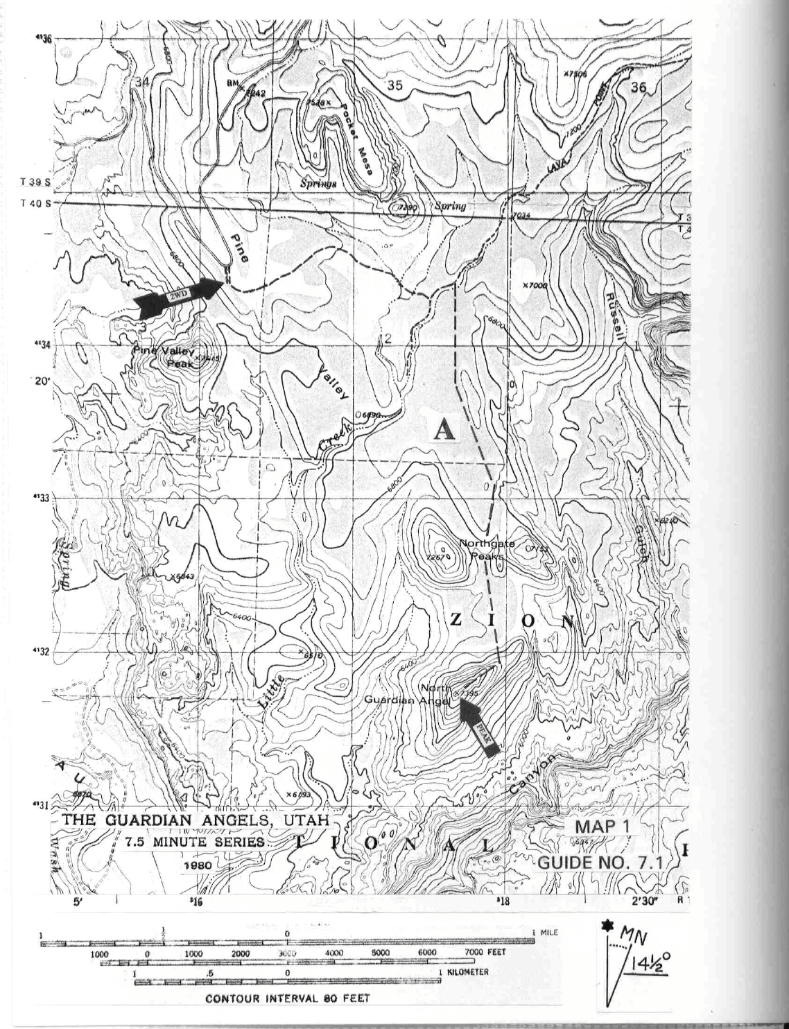
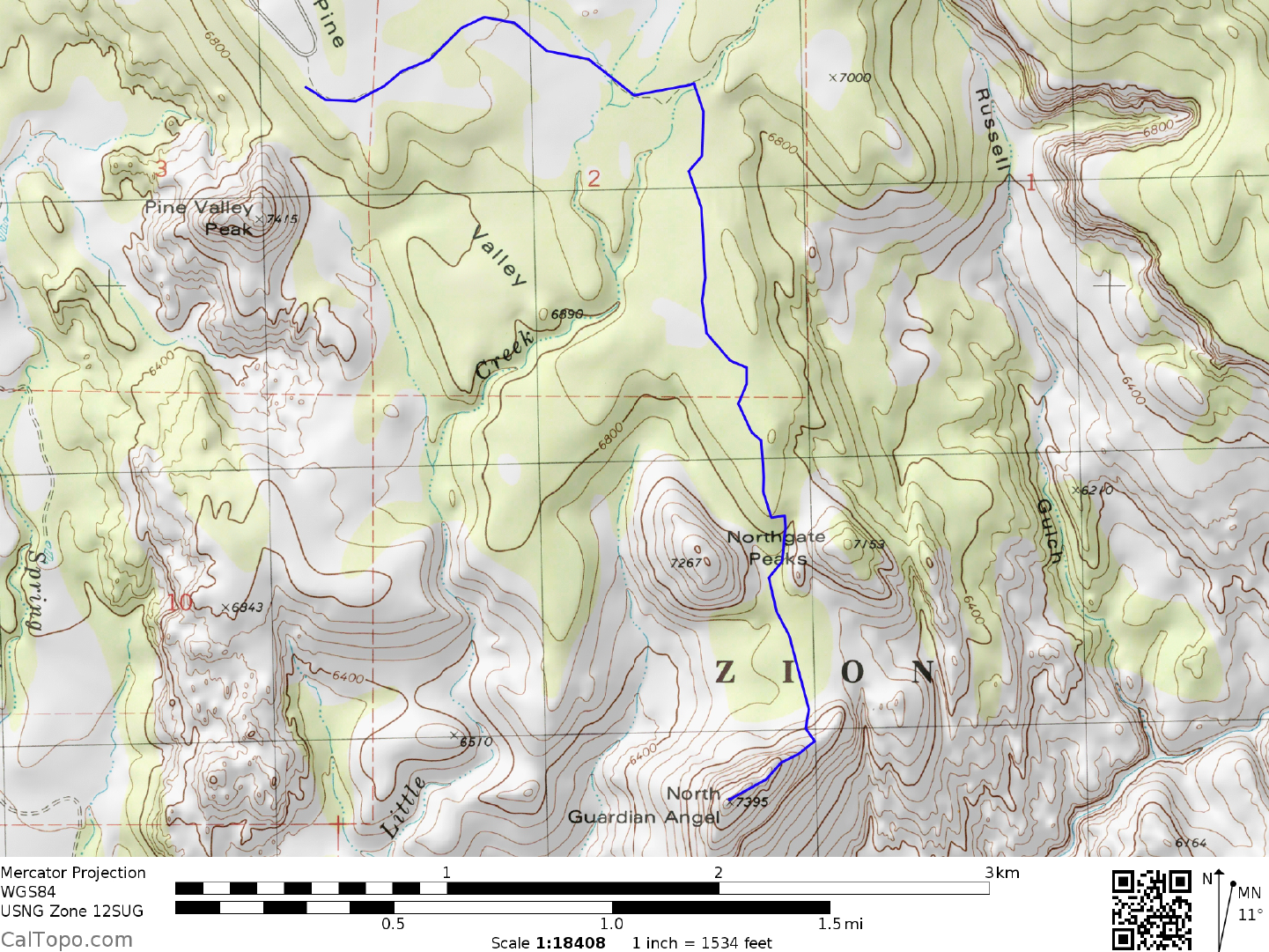
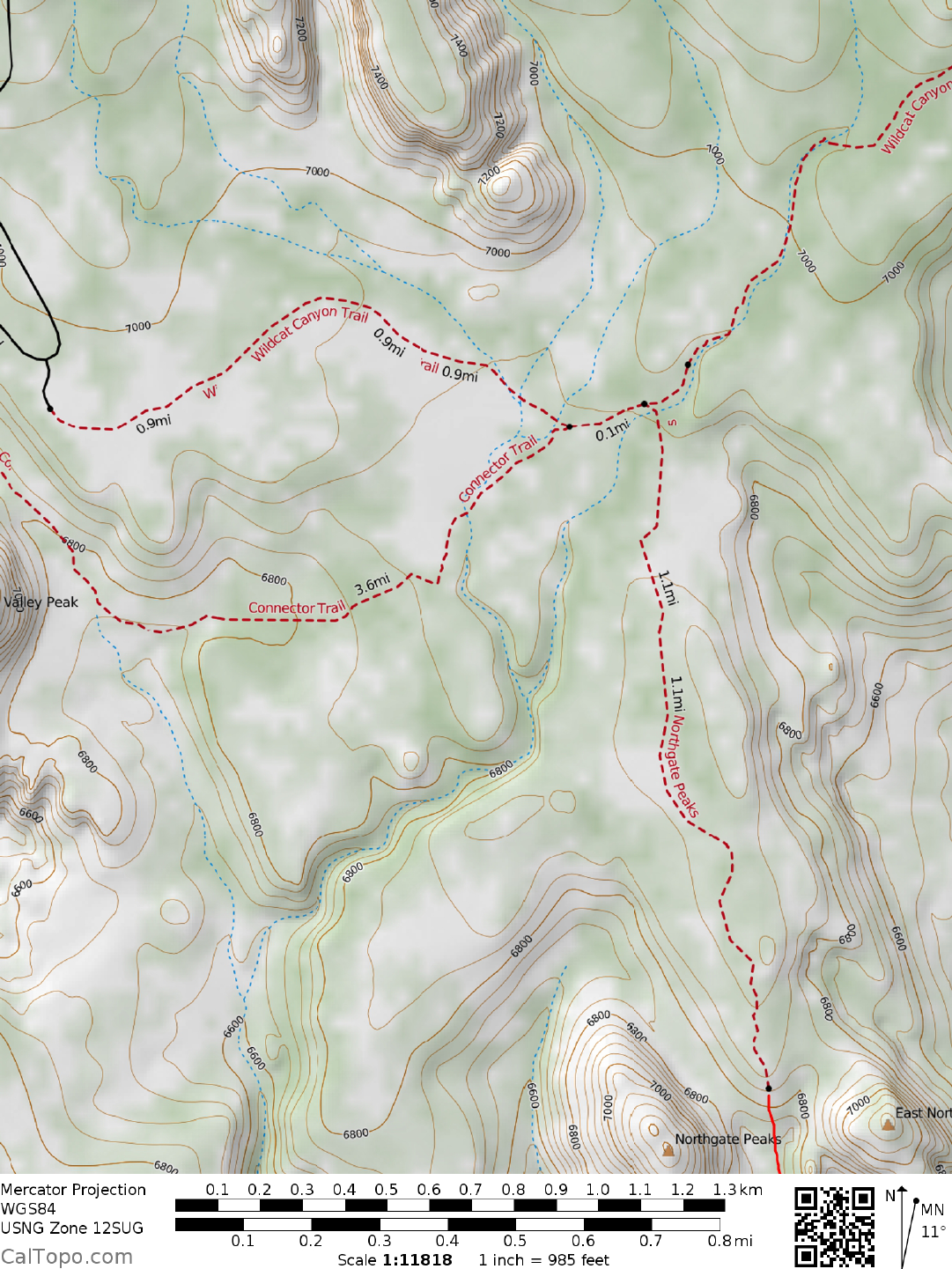
CLIMB/ROUTE A: See Map 1. Walk 1.0 mile E on the
Wildcat
Canyon Trail to a trail junction and small
metal sign reading "Hop Valley/West Rim". Continue straight (E) on trail for 250 yards, over a small hill, to a
second metal sign reading "Northgate Peaks/Wildcat Canyon". Turn right (S) here, following the Northgate
trail about 1.0 mile to its end near point 6960+ at UTM 179331. It's here that you'll have a full view of the
North Guardian Angel. Drop down into a gully on the left, following it to the gap between the Northgate
Peaks. Continue 0.4 miles S to the base of the Angel (joining Route B here) and ascend the red and white
sandstone face (friction walk) to the flat ridgeline above, where you'll slip into your climbing harness. Climb
SW up the ridge about 70 feet to a large pine tree. An easier but more exposed route to this tree is found by
climbing up and right to a crack that is followed to the tree (This tree makes a good belay anchor on the
ascent and a rappel anchor on the descent). From here climb up and left to a 10" diameter pine tree growing
very close to a rock slab on its right. Chimney up between the tree and this rock slab for 5 feet, following the
slab up over a small lip and continuing about 50 feet to a pine tree. Head left and up here along a 20 foot long
ledge, then straight up 20 feet to a very distinct pine tree growing horizontally out of the ground for 3 feet
before bending up to the vertical. This pine tree serves as a convenient belay anchor point. From here walk
up steep but easy slopes to the base of cliffs above. Heading left, contour below the cliffs to where you can
either a) traverse left around a rock rib (exposed with good handholds) and angle up loose slopes to the
summit ridge, or b) climb directly up the very steep, brushy cliff to the summit ridge. Either way, you'll end
up on the class 1 summit ridge, which is followed 300
feet SW to the top.
The minimum group climbing hardware a small party (4 or less) should take on this peak is one 9m
m (or
larger) x 45 meter long rope, two carabiners and two slings of 10 foot long x 1" nylon webbing. In addition,
each climber should have a seat harness with either one locking or two opposing carabiners and a Figure-8
rappel ring. To expedite climbing, large parties should consider taking 3 or 4 ropes, 4 carabiners and 4 slings
as minimum group climbing hardware.
Note: I used one 9x60m rope on two occasions, and it was sufficient.
ROUND TRIP STATS/ROUTE A: 800 feet of elevation gain, 7 miles, 7 hours
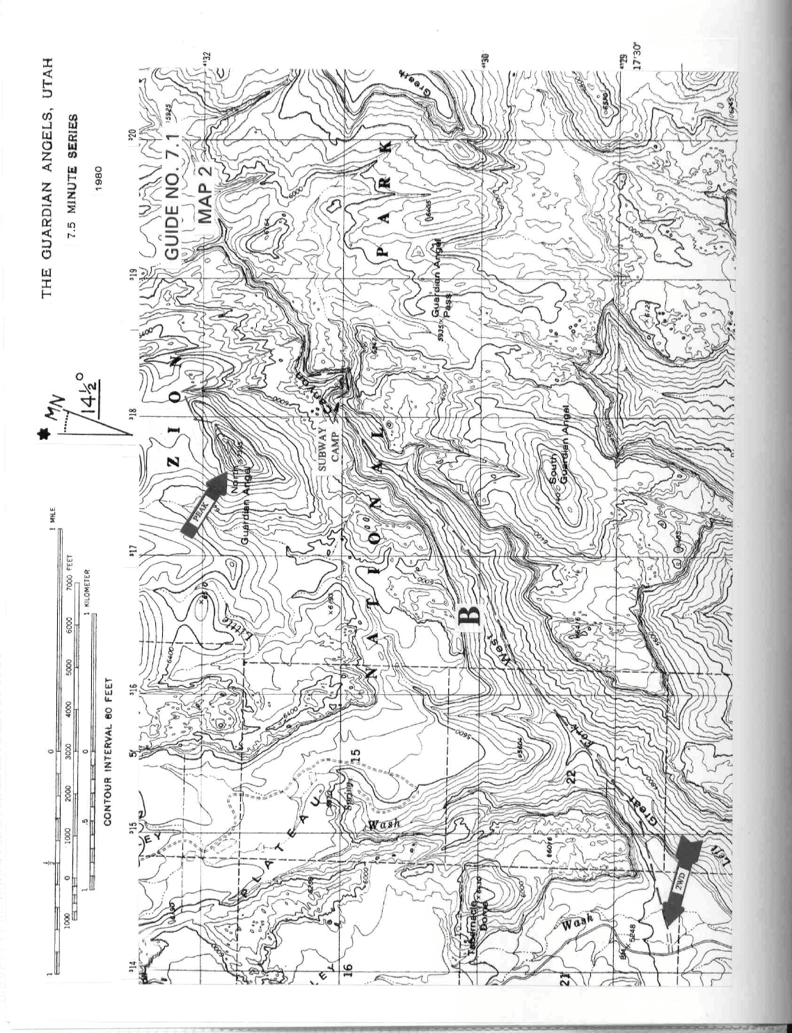
DRIVE/ROUTE B: The driving approach and parking spot for Route B is the same as described for the South
Guardian Angel, Guide No. 7.2. In other
words, drive to the large, unsigned parking area that marks the
trailhead for the Great West Canyon.
INTRODUCTION TO CLIMB: See Map 2. This route on the North Guardian Angel is not a one day
outing
like Route A. It will take m
ost groups between 2 and 3 days roundtrip to complete. If you're also going to be
NORTH GUARDIAN ANGEL (CONTINUED)
7 UTAH RANGES GUIDE NO. 7.1
climbing the South Guardian Angel, an advantage of Route B is that it shares the same basecamp with the
North Angel, a spectacular site deep within the Great West Canyon known as The Subway. A backcountry
permit is required for Route B (See Sidelines below).
CLIMB/ROUTE B/DAY 1: Follow Climb/Day 1 directions for South Guardian Angel, Guide No. 7.2 to the
upstream
end of the Slime Traverse.
CLIMB/ROUTE B/DAY 2: Repeat yesterday's course past each barrier to a point about 100 feet beyond the
upstream
end of the Slime Traverse. Here, turn left (directly opposite from where you'd climb out of the
canyon for the South Guardian Angel) up steep dirt slopes for about 70 feet to a headwall. Climb right (E),
gaining a ridge which is followed N (looking for frequent rock ducks) to about the 6800 foot elevation level.
At this point you will be able to head left (W) around the N side of the Angel to a red and white sandstone
face (friction walk) where you'll join up with Route A, which is followed to the top.
The recommended climbing equipment for Route B is the sam
e as listed in South Guardian Angel, Guide No.
7.2, Sidelines 3.
ROUND TRIP STATS/ROUTE B/BACKPACK ONLY: 1300 feet elevation gain, 6 m
iles, 5-6 hours
ROUND TRIP STATS/ROUTE B/CLIMB ONLY: 2200 feet elevation gain, 3.5 miles, 8 hours**
ROUND TRIP STATS/ROUTE B/TOTAL TRIP: 3500 feet elevation gain, 9,5 m
iles, 2-3 days
** These hours do not include the rope set-up time described in CLIMB/DAY 1
SIDELINES
1. See Sidelines 1, 2 and 4 of South Guardian Angel, Guide No. 7.2 for important information on camping
and backcountry
permits.