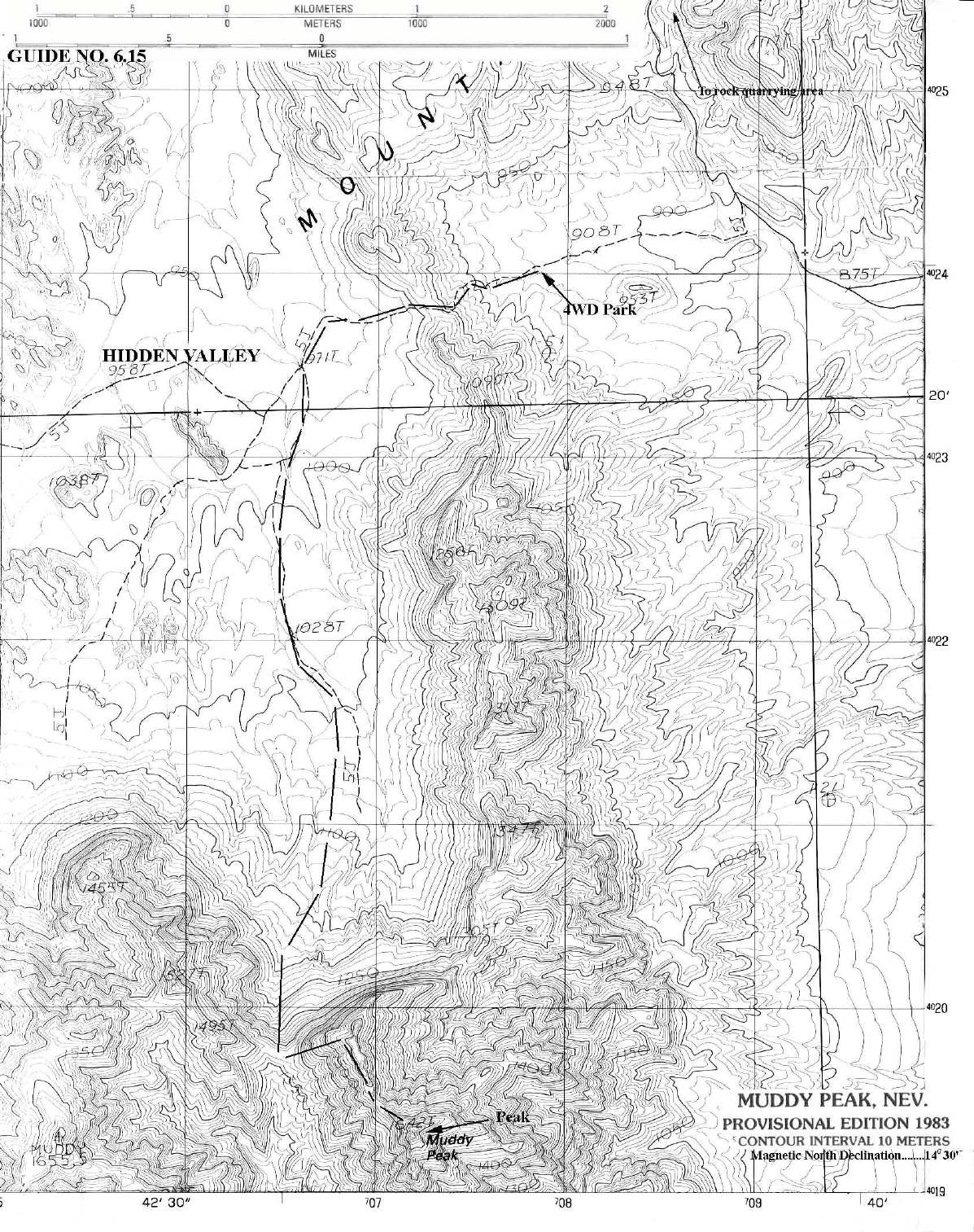
6 NEVADA RANGES GUIDE NO. 6.15
MUDDY PEAK 5387 FEET CLASS 3
MILEAGE: 330 miles of paved road, 8.3 miles of good dirt road, 2.6 miles of poor dirt road.
DRIVE: From Las Vegas, NV. Drive approximately 32 miles N on Interstate 15, leaving the
highway at Exit 75 signed “Valley of Fire, Lake Mead”, State Route 169. Drive 3.1 miles SE
on Route 169 to where the road starts curving left (less than 0.1 miles past highway milepost
3). Leave Route 169 here, continue straight (SE) 0.1 miles to the end of pavement and start of
a good dirt road. A BLM sign here welcomes you to the Bitter Springs Trail, a designated
backcountry byway. Zero your odometer. At 4.2 miles see the sign to Buffington Pockets.
At 5.2 miles the road becomes HC 4x4 as you enter the rocky wash. At 6.7 miles you'll exit the wash.
The road will continue to be rough and rocky. At 9.5 miles you'll pass the rock quarry.
From the rock quarrying area continue on the main road for 1.6 miles, as it climbs up hill,
drops into a canyon, and then reaches a faint dirt road going off to the right (S). Turn right
here. The faint dirt road goes South a short distance and then turns right following the wash
heading generally (W) towards a low ridge or saddle. Continue up the wash driving about 1
mile to the road closure at a large, metal sign. Park here.
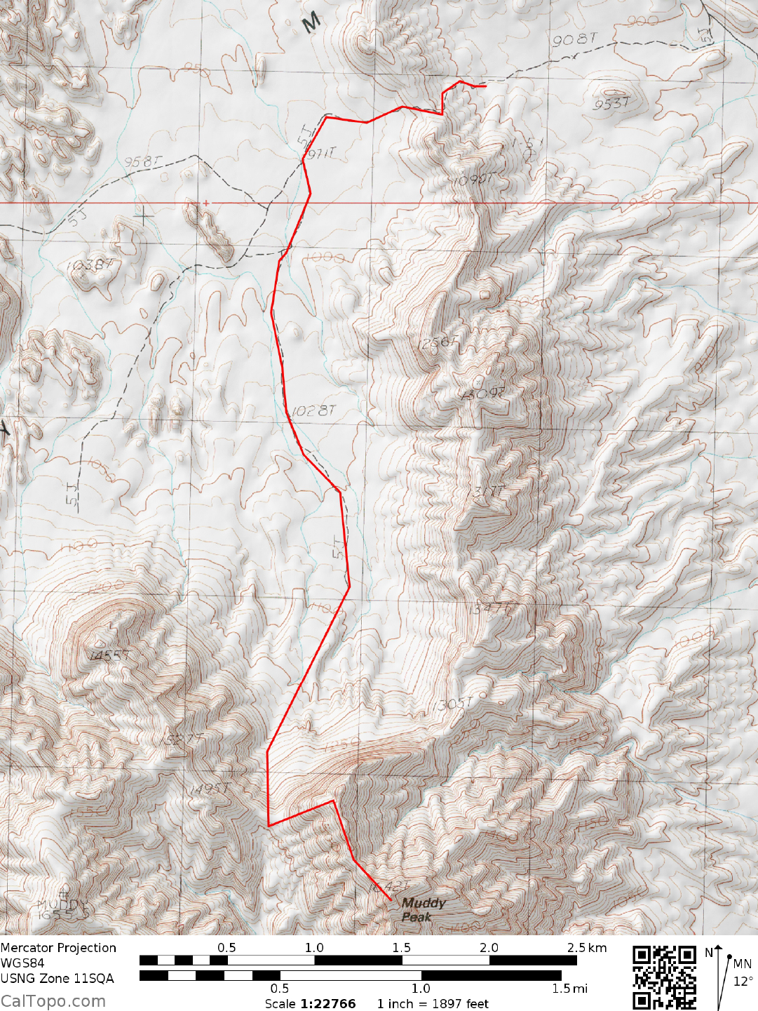
CLIMB: Hike W, following the closed road over the low ridge and dropping into Hidden
Valley. Continue following the road in Hidden Valley, first W then generally SW past
elevation 971T. Continue S on the road past elevation 1028T. Look S about 1.5 miles away
there is a saddle. Note below this saddle on the left at the base of the mountain is a beautiful
area of bright red-orange and white colored sandstone. Hike to this saddle 1370+ meters
(UTM 065198) 0.5 miles NW of Muddy Peak). From the saddle continue E up steep slopes to
just below the ridgeline, then follow the ridgeline SE to a notch at the base of the steep summit
mass. Head directly up the ridge to a loose chute and follow the class 3 ridge to the summit.
ROUND TRIP STATS: 2500 feet of elevation gain, 8.5 miles, 8 hours
SIDELINES
1. Near-by Valley of Fire Sate Park is and interesting place to visit. It is Nevada’s
oldest state park. The park features brilliant sandstone formations and Indian
petroglyphs. There are geology exhibits at the visitor’s center.
2. From the saddle nearby Muddy Mountain may also be easily climbed. Muddy
Mountain is the range high point.