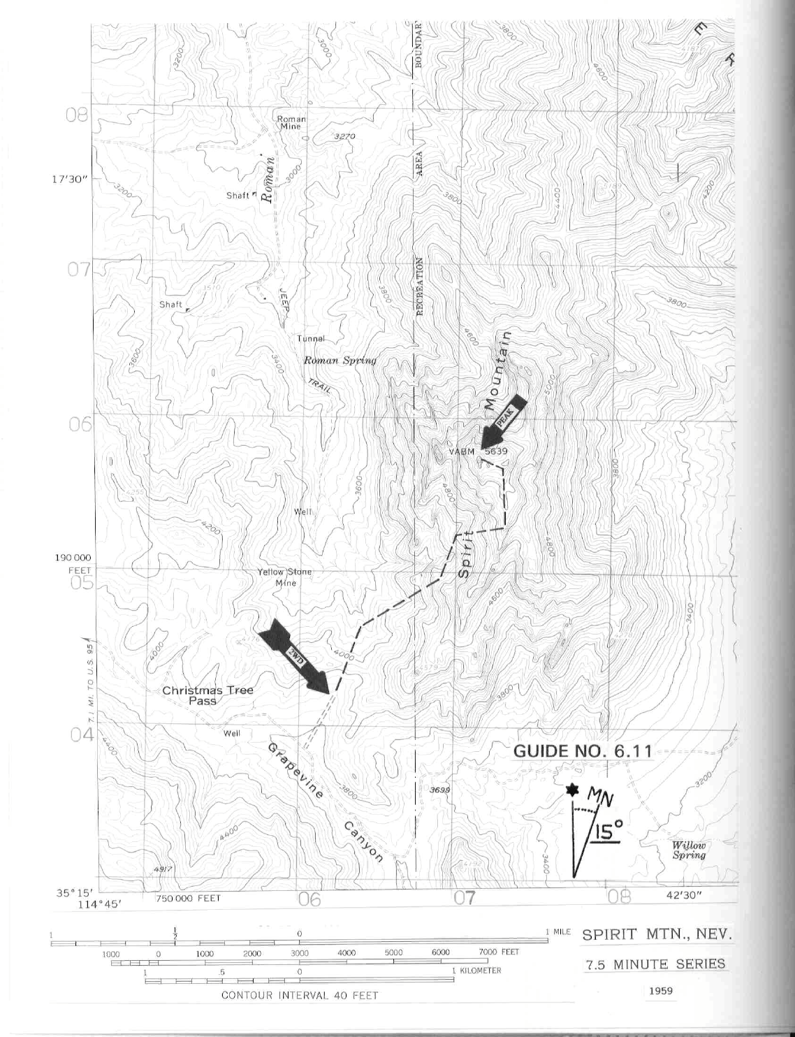
6 NEVADA RANGES GUIDE NO. 6.11
SPIRIT MOUNTAIN 5639 FEET CLASS 2
MILEAGE: 285 miles of paved road, 8.3 miles of good to excellent dirt road.
DRIVE/NORTHERN APPROACH: From Searchlight, NV drive 13.8 miles S on US Highway 95. Turn left
(E) here on an excellent dirt road (This dirt road is 5.3
miles N of the State Highway 163 turnoff for Laughlin,
NV), following it 7.5 miles to its highpoint at Christmas Tree Pass. Continue over the pass 0.6 miles to a
faint dirt road heading left (N).
Park.
DRIVE/SOUTHERN APPROACH: From Ludlow, CA drive 83 m
iles E on Interstate 40 to its junction with
US Highway 95 North (This junction is also reached by driving 11 miles W from Needles, CA on Interstate
40). Exiting here, drive 28.4 miles N on US Highway 95 (5.3 miles beyond or N of the State Highway 163
turnoff for Laughlin, NV) to an excellent dirt road heading right (E). Follow DRIVE/NORTHERN
APPROACH directions from this point (over Christmas Tree Pass) to the start of the hike.
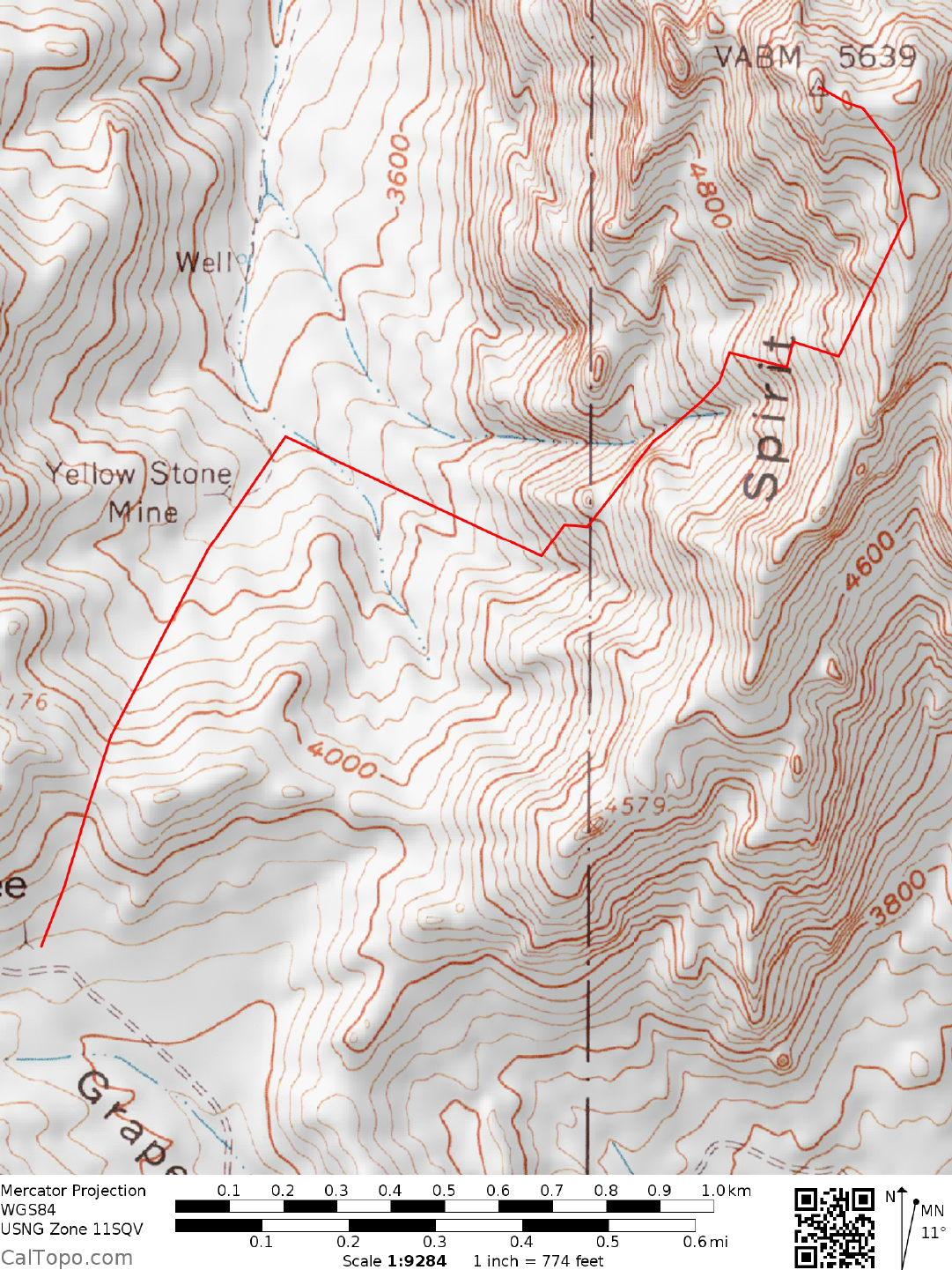
CLIMB: Hike N
to a saddle at 4040+ feet elevation. Continue N from
here 0.2 miles, losing about
150
feet
of elevation en route. Now turn NE at a bearing of 55° and climb up toward the broken southwest
face of the mountain, passing just to the S and W of point 4280+ (UTM 067049). Drop into the prominent
wash N of point 4280+ and follow it upward until progress is blocked by large dry waterfalls. At this point
climb left out of the wash on easy slopes, gaining the summit ridge at about the 5400 foot elevation level.
Turn left (NNW) and follow the easy ridgeline 0.25 miles to the summit flats, where you'll bear left and walk
200 feet to the actual highpoint of Spirit Mountain, a high Class 2 block which is climbed from its eastern
side.
ROUND TRIP STATS: 2000 feet elevation gain, 3 miles, 4-5 hours
SIDELINES
1. According to Indian legend, Spirit Mountain is the dwelling place of deceased chieftains, hence the name.
The Newberry Mountains, which include Spirit Mountain and the Dead Mountains to the south in California
were both avoided by the Indian bands living in this area.
2. Nearby Grapevine Canyon offers a very impressive assortm
e
nt of Indian petroglyphs for viewing.
Excavations of a small cave in the canyon near the parking lot revealed that this area was used by prehistoric
Indians known as the Amacava People (ancestors to the modern day Mohaves) and Southern Paiute. The use
of the cave began as early as 1100 AD and continued into historic times. Besides the Indian artifacts,
Grapevine Canyon also has a small desert spring that flows nearly year-round from the canyon floor. Because
of the presence of water, the canyon has an abundance of vegetation that contrasts sharply with the drier
hillsides. To get the site drive 13 miles E from US Highway 95 on Nevada State Highway 163 (towards
Laughlin, NV) to highway milepost marker 13. Turn N here on a good dirt road, following it 2 miles to a
signed turnoff for Grapevine Canyon. Turn left, driving 0.25 miles to the end of the road at a large parking
area. Hike W about 0.2 miles from the parking lot to the mouth of Grapevine Canyon and the start of the
petroglyphs.