6 NEVADA RANGES GUIDE NO. 6.7 & 6.8
CHARLESTON PEAK 11915 FEET CLASS 1
MUMMY MOUNTAIN 11528 FEET CLASS 2
MILEAGE: 327 miles of paved road.
This guide includes two basic approaches to Charleston Peak and Mummy Mountain. The first approach is
via Ky
le Canyon and the second is by way of Lee Canyon.
Kyle Canyon has two main footpaths of interest to the
peakbagger, the North Loop and South Loop trails.
These trails, 11 and 9 m
iles in length respectively with trailheads about 1.4 miles apart, meet on the summit of
Mt. Charleston, thus forming a 20 mile long loop trail. Although this loop trail doesn't quite reach the summit
of Mummy Mountain, it approaches to within about 0.75 mile and 1150 feet elevation of the top, making for
convenient access to that peak. In the following writeup, two routes (A and B) have been included from Kyle
Canyon, each utilizing a portion of the 20 mile loop trail. Route A details the South Loop Trail in its entirety
from the Cathedral Rock Picnic Area to the summit of Mt. Charleston. Route B describes the North Loop
Trail from its trailhead to the takeoff point for Mummy Mountain plus the additional cross-country travel
required to reach Mummy's summit. A description of the North Loop Trail between the summit of Mt.
Charleston and the takeoff point for Mummy Mountain has also been included to assist those planning a trip
that encompasses the entire loop.
The Lee Canyon approach (Route C) details a cross-country
route from
that canyon to its junction with the
North Loop Trail at a point between the summits of Charleston and Mummy.
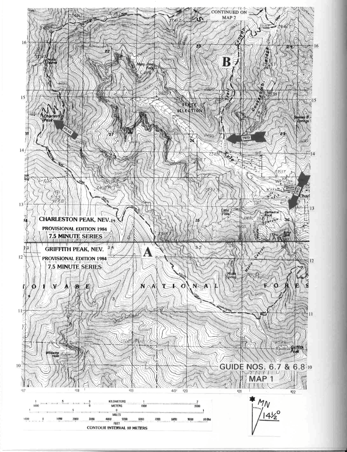
DRIVE/ROUTES A & B/KYLE CANYON: From the intersection of Interstate 15 and US Highway
95 in
Las Vegas, NV drive about 16 miles N on US Highway 95 to the signed "Toiyabe National Forest, Kyle
Canyon" State Highway 157 junction. Turn left (W) on paved State Highway 157 and drive 20.8 miles to
where the road makes a hairpin turn to the left. Here you have two options, depending on the trailhead from
which you intend to start your climb. By choosing to leave State Highway 157 at the beginning of the hairpin
turn, you'll drive 0.4 miles on the signed Echo Road (paved then excellent dirt) to a fork. Bearing right, drive
0.2 miles to where the road curves uphill to the right. Here you'll find a trailhead information board marking
the beginning of the North Loop Trail. Parking is available just down from this sign. By opting to follow
State Highway 157 through the left hairpin turn, continue about 0.3 miles to a signed fork for the Cathedral
Rock Picnic Area (a gate here limits entry into the picnic grounds from 8AM to 8PM daily). Bear right and
drive 0.4 miles to the South Loop trailhead parking lot adjacent to the picnic area.
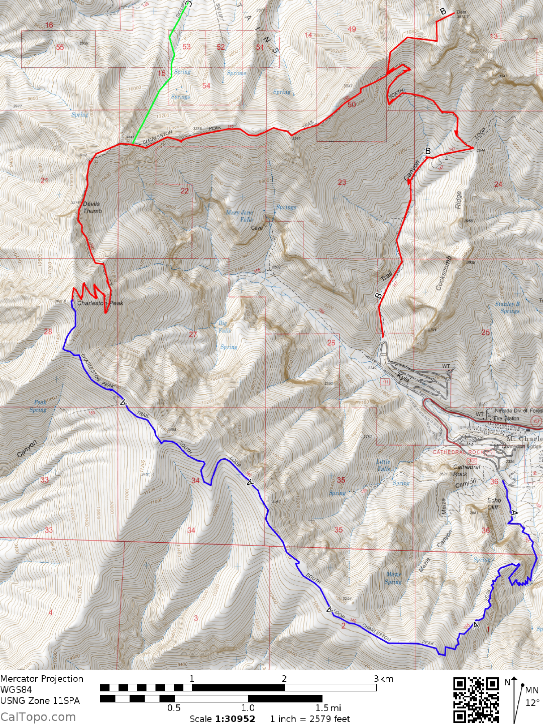
CLIMB/ROUTE A/CHARLESTON PEAK: See Map 1. From the South Loop parking lot adjacent to the
picnic area, hike E up the paved road, passing the signed Cathedral Rock trailhead on y
our right in about 30
feet. Continue 150 feet up the road to the South Loop trailhead, marked with a large wooden sign reading
"Charleston Peak Trail No. 145". Follow this well graded trail as it climbs the steep eastern
CHARLESTON PEAK/MUMMY MOUNTAIN (CONTINUED)
6 NEVADA RANGES GUIDE NO. 6.7 & 6.8
scarp of the Spring Mountains to the crest at 3260 meters (10,700 feet) elevation. The trail now heads
northwest along the ridge through grassy meadows and a rich forest of Bristlecone pine (good overnight
campsites here). Along this stretch of trail you'll have spectacular views of the desert landscape to the west
and Mummy Mountain and beyond to the east. Approaching Charleston, the trail breaks through timberline to
barren, windswept slopes that are followed to the summit.
ROUND TRIP STATS/ROUTE A/CHARLESTON PEAK: 4300 feet elevation gain, 18 miles, 9 hours
CLIMB/ROUTE B/MUMMY MOUNTAIN: See Map 2. Starting at the North Loop trailhead, follow the
trail N up Trail Cany
on about 2 miles to a saddle and trail junction at 2844 meters (9330 feet) elevation. Turn
left here, following the trail uphill about 0.5 miles to a wooden water trough that collects the output of a spring
located just above the trail. About 1.25 miles beyond this trough, just past the last trail switchback on a wide
scree slope (UTM 208173), leave the trail and head N, gaining about 330 feet of elevation to a saddle. Turn
right (NE) at this saddle, following the ridge about 0.50 miles to a rock wall just beneath the summit plateau.
Traverse left (NNW) about 100 yards along the base of the wall to a break in the cliffs, then right (NE) to the
summit.
ROUND TRIP STATS/ROUTE B/MUMMY MOUNTAIN: 3750 feet elevation gain, 10 m
iles, 7 hours
BOTH PEAKS: See Maps 1 & 2. If you intend to climb either one or both peaks in a
loop trip by starting at
one trailhead and ending at the other (e.g. North Loop to South Loop or vice versa) you'll either have to
arrange for a 1.4 mile car shuttle between trailheads or plan on walking that additional mileage. The ROUND
TRIP STATS given below assume that a car shuttle has been arranged between the trailheads. Following is a
description of the North Loop trail from the summit of Charleston Peak to where you'd leave the trail for
Mummy Mountain (see Route B above). This information, along with the trail descriptions of Routes A and
B above will fully describe the 20 mile North/South Loop trail. From the summit of Charleston hike N,
following the trail as it drops steeply down the E face of the mountain. After switchbacking down about 900
vertical feet and 1.0 mile from the top, the trail strikes N and contours along steep cliffs for another mile to a
prominent rock tower called the Devils Thumb.
The trail continues N from here about 0.5 miles before turning E, running for 2.0 m
iles along the S side of the
ridge that separates Kyle and Lee canyons. Near point 3347 the trail leaves the ridge and starts a steady
descent through a burned out forest of trees into upper Trail Canyon. About 0.4 miles past point 3347 the trail
makes a right switchback on a wide scree slope. Just before reaching this switchback you'll come to the cross-
country takeoff point for Mummy Mountain (See Route A). If you are doing Mummy via Charleston, there is
a tendency to leave the trail near point 3347 and climb the ridge toward Mummy. Avoid this temptation as
tough rock on the ridge makes the going slow and difficult.
ROUND TRIP STATS/LOOP TRIP/BOTH PEAKS: 6200 feet elevation gain, 21.5 miles, 12 hours
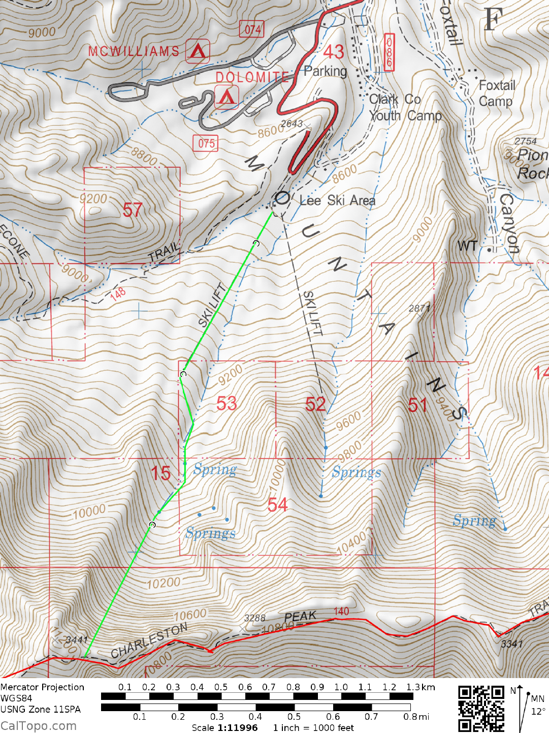
DRIVE/ROUTE C: From the intersection of Interstate 15 and US Highway
95 in Las Vegas, NV drive 27.9
miles N on US Highway 95 to the signed "Lee Canyon" State Highway 156 junction. Turn left (SW) on
paved State Highway 156 and drive 17.3 miles to the end of the road at the Lee Canyon Ski Area. Park. You
CHARLESTON PEAK/MUMMY MOUNTAIN (CONTINUED)
6 NEVADA RANGES GUIDE NO. 6.7 & 6.8
can also reach the ski lifts by following the DRIVE/ROUTES A & B directions to the signed "Kyle Canyon"
State Highway 157 junction, turning W and driving 17.6 miles to State Highway 158. Turn right (N) on State
Highway 158, following it to its end in 9 miles at State Highway 156 in Lee Canyon. Turn left and drive 3.3
miles to the end of the road at the ski lifts. All of these roads are clearly shown on the Las Vegas inset of the
AAA San Bernardino County road map.
CLIMB/ROUTE C: See Map 2. Hike S under the westernmost ski lift and then up the canyon to the ridge,
where
you'll intersect the North Loop trail at saddle 3288 (UTM 185165). Turn right (W), following the
North Loop trail about 3.5 miles to reach the summit of Charleston. To reach Mummy, turn left (E) and hike
about 2.0 miles on the North Loop trail to the cross-country takeoff point described in Route B/Mummy
Mountain. Leaving the trail here, follow Route B directions to the summit.
ROUND TRIP STATS/ROUTE C/CHARLESTON PEAK: 3400 feet elevation gain, 10 miles, 8 hours
ROUND TRIP STATS/ROUTE C/MUMMY MOUNTAIN: 3000 feet elevation gain, 9 m
iles, 8 hours
ROUND TRIP STATS/ROUTE C/BOTH PEAKS: 4200 feet elevation gain, 17 miles, 12 hours
SIDELINES
1. Charleston Peak was named in 1869 by a topographic mapping group of the United States
Army Engineers and commemorates the city of Charleston, South Carolina. The Southern Paiutes called the
peak Nüvant, and both they
and the Chemehuevi revered it as a very important place in their mythology. The
peak is the "rooftop" of Southern Nevada and the fourth highest named mountain in the state, with only
Wheeler, Boundary and the South Summit of Mount Jefferson being higher.
2. Mummy Mountain was named because of its resemblance to the full-length profile of an Egyptian mummy
when
viewed from the NE. From the intersection of US Highway 95 and State Highway 156 at the Lee
Canyon turnoff you'll be able to recognize the mummy shape.
3. The best season for hiking Charleston and Mummy is usually
from June until the first snowfalls of winter.
In years of heavy snowfall, large patches of snow can linger along shady recesses of the trail well into July.
The North Loop trail between the summit of Charleston and the Devils Thumb is particularly well shaded in
some steep areas. Snow here can make travel difficult and potentially dangerous because of bad runout over
cliff faces. It would be wise to have an ice axe available if such a condition presents itself.
4. The last two miles of the South Loop trail before the
summit of Charleston cut across a large marine fossil
bed, proof that this high country was once the floor of an ancient sea. Keep a lookout among the dark rock for
small sea creatures (snails, tube worms, oysters and scallops) preserved in stone. It's estimated that these
fossils are between 150 and 600 million years old. Another point of interest on the South Loop trail is the
wreckage of a large airplane about 0.5 miles S of the summit at 3500 meters (11480 feet) elevation.
CHARLESTON PEAK/MUMMY MOUNTAIN (CONTINUED)
6 NEVADA RANGES GUIDE NO. 6.7 & 6.8
5. There are 5 established campgrounds in the area of Lee and Kyle canyons. They all charge a fee for
overnight camping. All campgrounds are open May 1 through September 30 and have picnic tables, fire
rings, piped water and toilet facilities. In Kyle Canyon you'll find the Kyle Canyon Campground (19 family
sites, 6 group sites) and Fletcher View Campground (12 family sites), both at 7100 feet elevation. In Lee
Canyon you'll find the Dolomite Campground (31 family sites) and McWilliams Campground (31 family
sites, 9 group sites), both at 8500 feet elevation. Between Kyle and Lee canyons on State Highway 158 is the
Hilltop Campground (36 family sites) at 8400 feet elevation. A certain number of sites in each of these
campgrounds can be reserved in advance through MISTIX at 1-800-283-2267. The rest are available on a
first come/first served basis.
C