6 NEVADA RANGES GUIDE NO.6.3
ARC DOME 11773 FEET CLASS 1
MILEAGE: 406 miles of paved road, 27 miles of good to fair dirt road
DRIVE/ALL ROUTES: From Bishop, CA. drive 53 miles N on US Route 6 to Basalt, NV., turning left on
State Route 360. Drive 23 miles Non State Route 360 to its junction with US Route 95. Turn left (N) and
drive 18 miles to State Route 361 just past the town of Luning, NV. Follow State Route 361 33 miles N to the
signed Berlin Icthyosaur State Park (approximately 1 mile N of the town of Gabbs, NV.) and turn right (E) on
a paved, two-lane road. At pavement end in 12 miles, continue E on excellent dirt for 3.4 miles to a fork,
where you'll bear left. In 3.3 miles you'll pass the Berlin turnoff sign (don't turn here) and in another 2.9 miles
come to a fork. Bear right at this signed fork "Ione 1 mile, Road 021" and go 0.6 miles to the town of Ione,
NV. Continuing E through town, drive 7.6 miles to the Reese River Valley dirt road at the Yomba Indian
Reservation. Turn left (N) on the Reese River Valley Road and proceed a short distance to the signed
"Stewart Creek 10 miles" junction just N of the quonset hut on the E side of the road. Turn right (E) and drive
0.4 miles to a fork. Bearing right, drive 0.5+ miles to a signed fork ("Stewart Creek 4, Clear Creek 5") and
bear right. 100 yards beyond this fork you'll make a stream crossing which, at the wrong time of year can
prove too deep for a 2WD vehicle. Just past this crossing, bear left at the fork signed "Stewart Creek 4".
You'll now be on signed road 119. Bear right at a fork in 0.6 miles and drive 1.0 miles to a fork, bearing right
again. In 2.8 miles, keep right at a fork and drop down to a second stream crossing. Continue 3.4 miles to
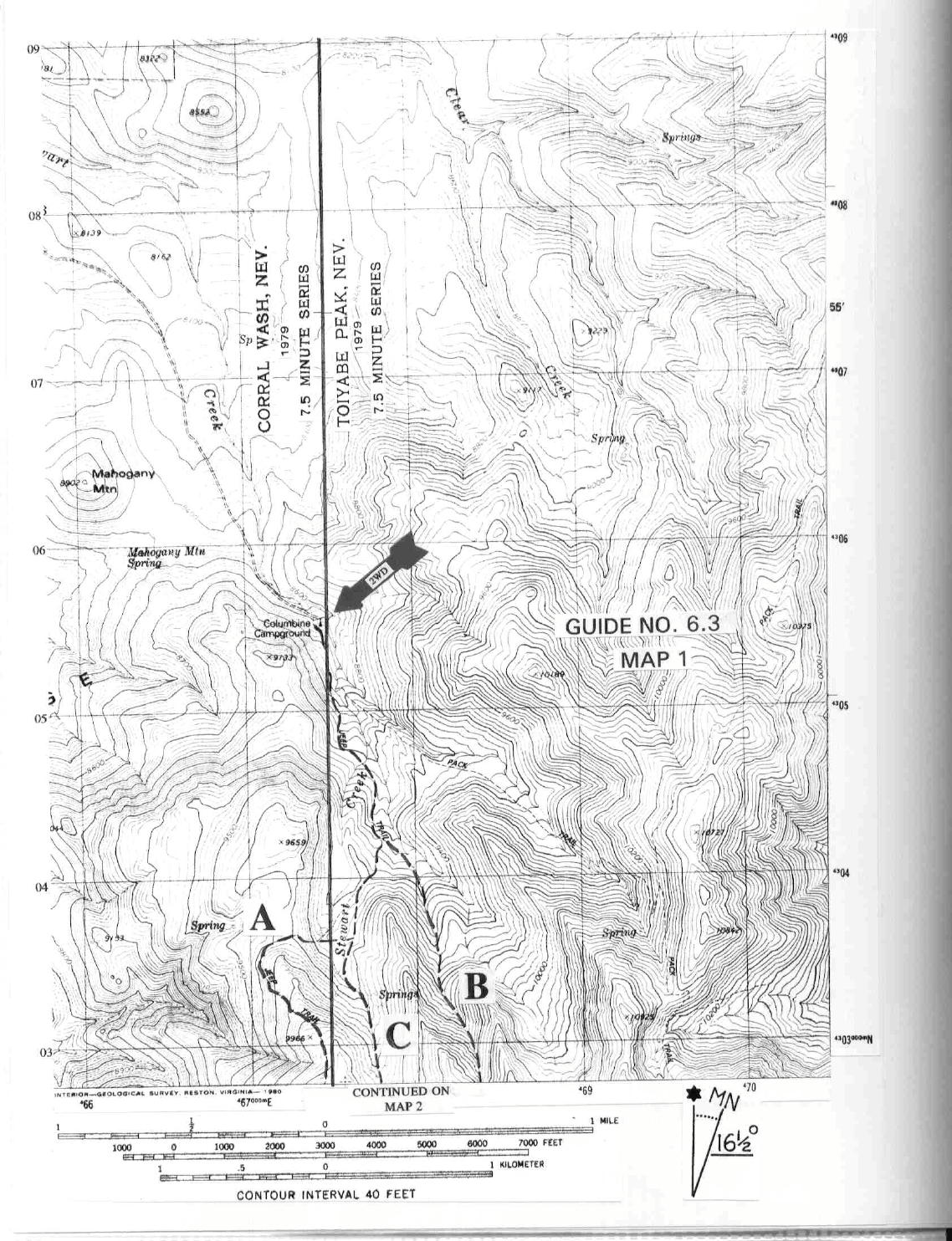
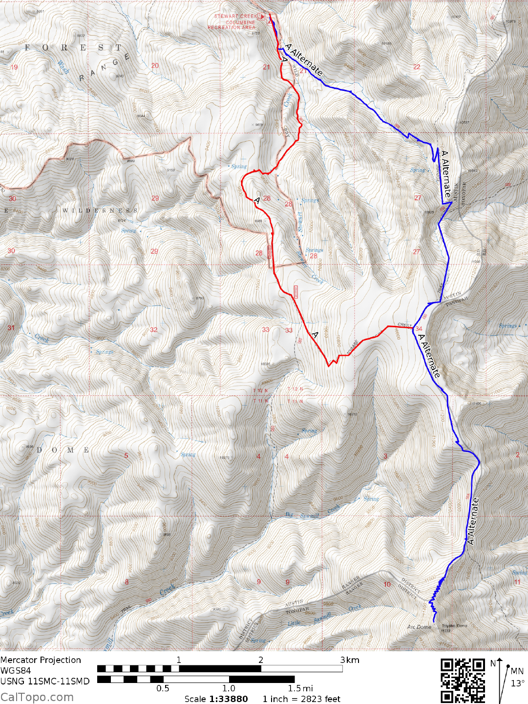
Columbine Campground and park.
CLIMB/ROUTE A: From Upper Columbine Campground hike SE on a 4WD road about 0.5 miles to a
locked gate at the 8800 foot elevation level. Passing through the gate and keeping a creek on your left, follow
the road another 0.8 miles through aspen forests to a small saddle (9400 foot elevation, UTM 677040) at the
foot of the fenced Stewart Creek Valley. Walk along the outside of the fence on the valley's eastern margin,
following the fence to its end. Turn right (W) and walk to the W end of the valley, where you'll pick up the
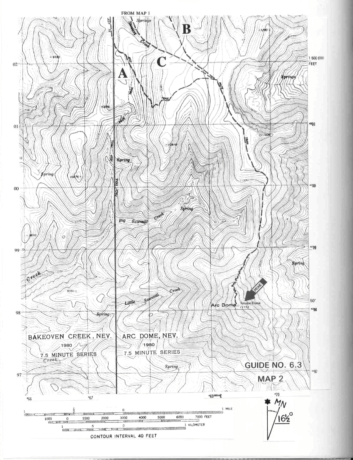
trail again as it switchbacks up the slopes to the west. Follow the trail (shown as Jeep Trail on the topos) to a
fork at 10,300 feet elevation. Turning left here, follow a steep, poor trail heading for the high plateau at
11,000 feet elevation. Upon gaining the plateau, the trail heads NE across flat ground for 0.7 miles to a trail
junction near the E side of the plateau. Turn right (SE) at this junction and follow the sometimes faint trail for
2.5 miles along the broad ridgeline to the summit. En route to the top you'll encounter a 600 foot drop to a
saddle 0.6 miles N of Arc Dome; an elevation loss which must be regained on the way back.
ROUND TRIP STATS/ROUTE A: 4600 feet elevation gain, 12 miles, 8 hours.
CLIMB/ROUTE B: From Upper Columbine Campground hike SE on a 4WD road for about 0.5 miles to a
locked gate at the 8800 foot elevation level. Passing through the gate and keeping a creek on your left, follow
the road another 0.5 miles to the 9200 foot elevation level. Leave the road here, following a canyon SSE for 2
miles to a high plateau at 11,000 feet elevation. Pick up a faint trail here and follow it
ARC DOME (CONTINUED)
6 NEVADA RANGES GUIDE NO.6.3
generally S for 2.5 miles to the summit. En route to the top you'll encounter a 600 foot drop to a saddle 0.6
miles N of Arc Dome; an elevation loss which must be regained on the way back.
ROUND TRIP STATS/ROUTE B: 4600 feet elevation gain, 11 miles, 8 hours
CLIMB/ROUTE C: From Upper Columbine Campground hike SE on a 4WD road for about 0.5 miles to a
locked gate at the 8800 foot elevation level.
Passing through the gate and keeping a creek on your left, follow
the road another 0.8 miles through aspen forests to a small saddle (9400 feet elevation, UTM 677040) at the
foot of the fenced Stewart Creek Valley. Walk along the outside of the fence on the valley's eastern margin,
following the fence to its end. Continue S, following the canyon S then SE to the high plateau at 11,000 feet
elevation. Pick up a faint trail here and follow it generally S for 2.5 miles to the summit. En route to the top
you'll encounter a 600 foot drop to a saddle 0.6 miles N of Arc Dome; an elevation loss which must be
regained on the way back.
ROUND TRIP STATS/ROUTE C: 4600 feet elevation gain, 11 miles, 8 hours
SIDELINES
1. Arc Dome is the highpoint of the Toiyabe Range. A variant nam
e for the peak is Toiyabe Dome. The
name is derived from the Shoshone word toyap, which means mountain.
$VRI-XQHERWKWKH%DQG&URXWHVZHUHKHDYLO\RYHUJURZQ