6 NEVADA RANGES GUIDE NO. 6.1
RUBY DOME 11387 FEET CLASS 2
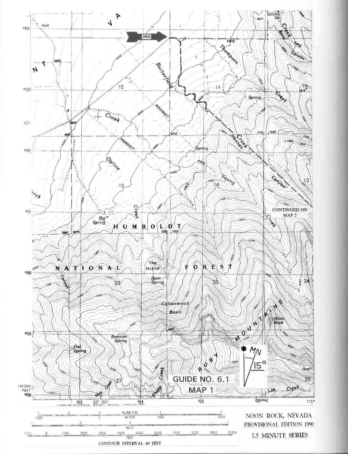
MILEAGE: 780 miles of paved road, 3 miles of excellent dirt road
DRIVE: From Elko, NV drive 17.2 miles SE on State Route 227 toward Lamoille, NV to the signed Pleasant
Valley Road. Turn right (S), driving 3.0 miles of excellent dirt to the locked gate entrance of the Spring Creek
Association
Campground. Unless you have a key to unlock the gate or permission to pass through the gate if
it is unlocked, plan to park your car just outside the gate and walk in the 1.5 miles to the upper end of this
private campground. There is a patrolling caretaker on duty who will enforce the privacy of this campground
with respect to entry by unauthorized vehicles. Access to the campground can be obtained by writing the
Spring Creek Property Owners Association, 401 Fairway Blvd., Elko, NV 89801 or by calling (702)
753-6295 Mon-Fri 8AM-5PM.
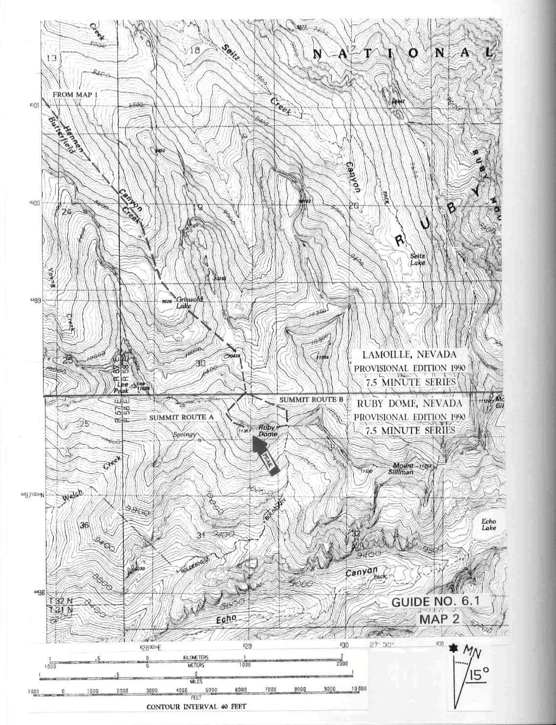
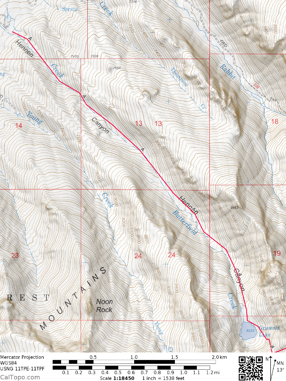
CLIMB: From the locked gate
hike 1.5
miles up the dirt road to the upper end of the cam
pground, where
you'll find two picnic tables and a BBQ pit at close to 6500' of elevation. Hike SE from here, following a trail
up forested Hennon
Canyon and staying on the left side of the creek until reaching some bare granite benches
near 8400 feet elevation. The trail to this point is fairly good, however there are some faint stretches along the way.
In general, the trail stays within 100 yards of the creek; so if you're further away from water than that, you're
probably off route. Ascending the benches to near the 8700 foot level on the creek, you can either stay on the left
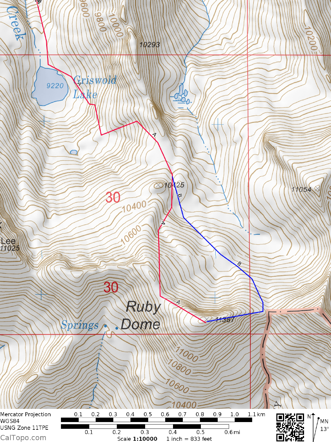
side of the creek or cross over to the right side and ascend a stable talus slope to Griswold Lake at 9220 feet elevation.
From the lake, climb SE up a gully over scree and talus to a saddle at approximately 10200 feet elevation, just N of
the prominent ridgeline "bump" at 10400 feet. From this point choose either of the following routes to the
summit.
SUMMIT ROUTE A: Hike around the left side of the 10400 foot ridgeline bum
p and climb
SW up a large, easy ramp
to the cirque NW of the peak. Ascend either of the two chutes
above the cirque to the W summit ridge. Head left (E) up the ridge to the peak. Since these
chutes are snow-filled much of the year, be sure to have an ice axe (and possibly crampons)
along on this route. Prevailing winds can produce large cornices over these chutes which
could make them a difficult and possibly dangerous ascent.
SUMMIT ROUTE B: Go around the left side of the 10400 foot ridgeline bum
p and climb
SW up a large, easy ramp to
the cirque NW of the peak. Contour left under the N face of the
mountain to a saddle at 10880+ feet elevation, 0.25 miles E of the peak. From the saddle
climb right (W) up the Class 2+ ridge to the summit.
Ruby Dome's sister peak, Ruby Pyramid
can be easily ascended from this same saddle by heading left.
ROUND TRIP STATS: 5400 feet elevation gain, 12 miles, 10-12 hours.
SIDELINES
1. Anyone who has climbed in the Rubies will agree that
it's one of the finest mountainous areas in the Great
Basin. The scenery is remi
niscent of the Sierra Nevada. Prior glaciation is evident in the numerous
RUBY DOME (CONTINUED)
6 NEVADA RANGES GUIDE NO. 6.1
ice polished cirques and U-shaped valleys found throughout the range. Because the range is so high and is
situated in a climatically wet part of the Great Basin, the vegetation in the lower canyons is extremely lush
and varied. This, coupled with the fact that the higher elevations receive an abundance of snow in the winter,
gives the Rubies a true alpine look.
2. The Ruby Range apparently received its name from an em
igrant party who traversed the foot of the range
in the 1850's and found semi-precious red garnets in the area.
3. Ruby Dom
e is the highpoint of the range.
4. Good camping can be found in Lamoille Canyon. To get there, drive back up the Pleasant Valley Road to
State
Route 227. Turn right (E) and drive 2 miles to Lamoille, NV. Turn right (S) here at a sign "Lamoille
Cany
on Campgrounds". In 2.3 miles you'll come to the Powerhouse Picnic Site off the right side of the road
(No overnight camping here). In another 5.2 miles is the Thomas Canyon Campground; 50 sites, pit toilets,
water available. And lastly, 2.8 miles beyond the Thomas Canyon Campground is the Terraces Campground
off the left side of the road. The Terraces has 10 sites with pit toilets and water available. There is also a
KOA Campground located about 11 miles E of Elko off Interstate 80 at Exit 314. It has a coin laundry,
grocery store, pool and hot showers.
5. Griswold Lake, NW of Ruby Dome, was named for Chauncy
W. Griswold, a settler who migrated west
from Missouri in the 1870's. He had a son, Morley
, who was elected governor of Nevada.
Revised 11-4-17