5 SAN DIEGO AND IMPERIAL COUNTY RANGES GUIDE NO. 5.4
PICACHO PEAK 1920+ FEET CLASS 6
See important note at end of this guide! (2/13/19)
MILEAGE: 307 miles of paved road, 14.55 miles of excellent dirt
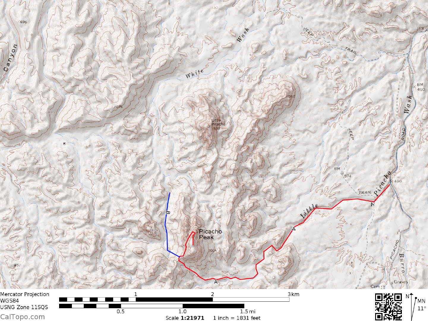
DRIVE/ROUTE A: From El Centro, CA drive approximately 55 miles E on California Interstate 8 to the
“Winterhaven Drive, Fourth Avenue” exit
(This exit is about 2 miles W of Yuma, AZ). Turn N over the
interstate to a stop sign at signed, paved County Road S24. Turn right on S24, following it 3.7 miles to where
it turns right (E) at Ross Road. Leave S24 here and continue straight (N) 0.7 miles to the end of pavement,
picking up an excellent dirt road that is followed 0.35 miles N then E to a spillway bridge just S of the All
American Canal. A sign here reads “Picacho State Recreation Area, 18 miles”. Cross the spillway bridge and
turn left, crossing a second bridge over the canal. Continue N approximately 13.4 miles to a signed fork at the
entrance to the Picacho Mine. Large tailings piles and chain link fences on the left (W) side of the road appear
as you near this fork. Bear right and drive 0.8 miles to a wide spot in the road at Little Picacho Wash. Park.
Any 2WD vehicle can make it to this spot.
NOTE: Because of the complex route description for "Little Picacho", this writeup is broken
down
into two segments, the hiking approach (Routes A & B) and the actual climb itself
(Same by either approach).
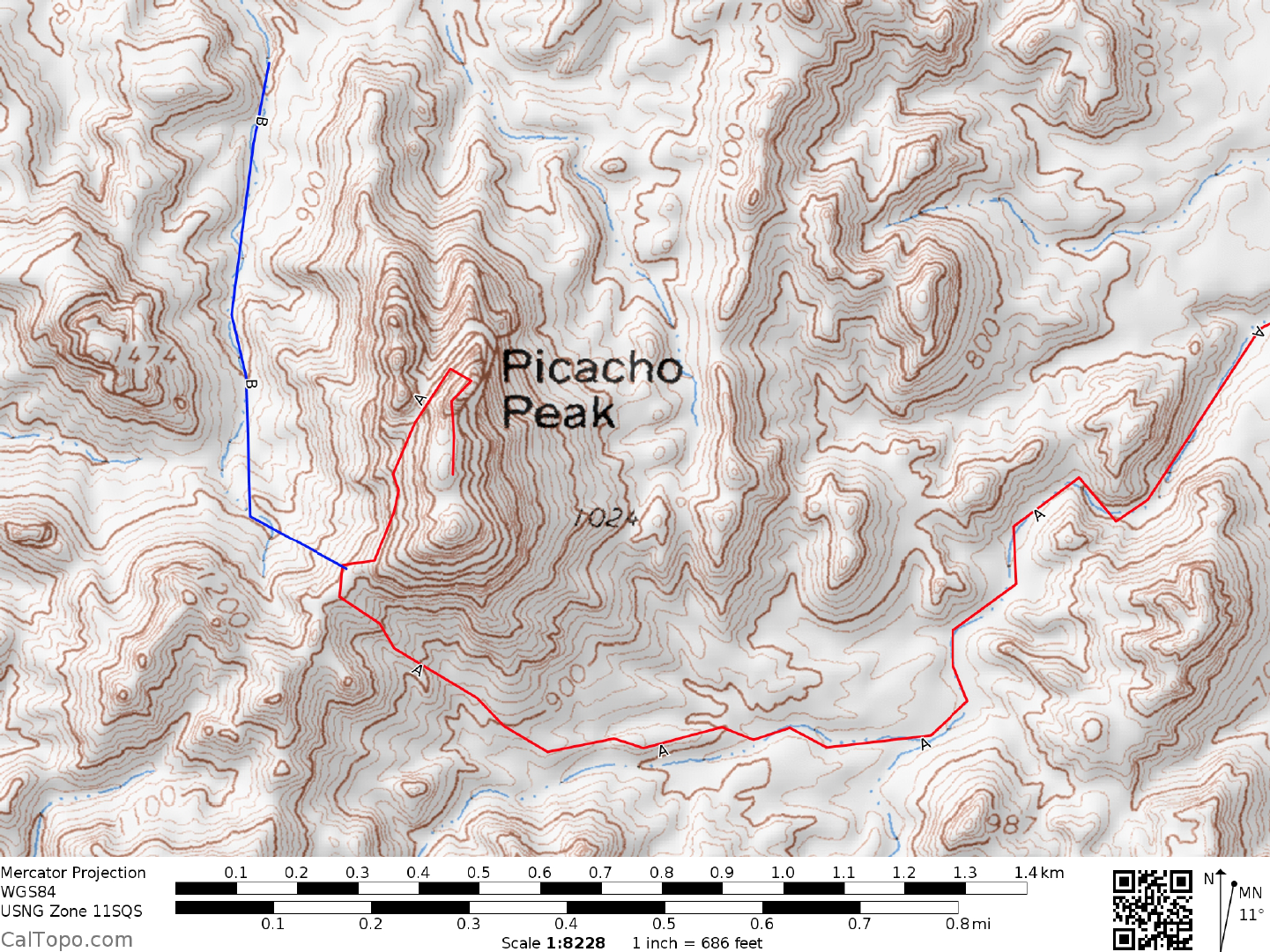
APPROACH/ROUTE A: From
the parking area walk 0.2 miles SW up Little Picacho Wash to a fork. Take
the right (W) branch, following it about 2.0 m
iles to a point 0.4 miles SSE of the peak. Climb NW to a saddle
at 1200+ feet elevation. Follow a good use trail N from here along the base of cliffs to the deep gully on
Picacho's W side. This gully
forms the division between the peak on the right and two sheer pinnacles on the
left. Follow the faint trail up this steep gully to a large notch.
CLIMB/ROUTES A & B: From the notch climb right, zigzagging
up ledges to the base of a sheer rock wall
above, where you'll turn left and follow a worn path to a 12 foot high, Class 4 step. A short wooden ladder
is found here. (As of 12/26/17 this ladder was cracked and
repaired with some webbing.) Once above this step
the next major obstacle
presents itself, a 3 foot wide jump-across that has turned back more than one climber!
Most people will probably want a rope here; a long drop into a dark slot if you miss. As a suggestion, fix and
leave one 45 meter rope here to secure the jump across and provide a top belay for the preceding 12 foot step move.
This way a large group can pass these obstacles quickly on both ascent and descent. A rock horn on one side of the
jump across and a large boulder on the other side are the only two natural anchors to protect this move. It is
also possible to climb down into the slot beneath the jump-across and work your way to the opposite side.
Once safely past this challenging barrier, follow ducked ledges to a 10 foot overhang. A
n aluminum ladder
here offers aid past the overhang. Because the ladder is somewhat unstable, the leader will probably want to
fix and leave a rope here for top belaying the group. There are two good belay anchor (bolted D-hangers)
available above the overhang. If you choose to do this overhang without using the ladder, it’s a high 5th Class
pitch. Above the overhang climb up then right around a point, heading SE past a shallow cave and on to the
false summit block. The false summit block can be tackled in two ways. First, it can be climbed on its N side
via an exposed 15 foot face of Class 4 rock. Once atop the block, three bolted D-hangers can be
found to secure and leave a rope for the 15 foot downclimb or rappel (and upclimb on the descent) on its S
side, after which it's just a hands-in-
PICACHO PEAK (CONTINUED)
5 SAN DIEGO AND IMPERIAL COUNTY RANGES GUIDE NO. 5.4
pocket stroll to the register. A pair of 5-step etriers come in handy on the S side of the false block to aid in its
re-ascent after returning from the peak. Alternately, the false summit can be bypassed on its E side by
descending 30 to 40 feet on awkward Class 4+ exposed rock to a worn path which is followed upward
through a distinctive window (hole through the rock). Once through the window, follow the path S to the
highpoint. A good belay spot just N of the false summit can be used to protect this downclimb on the E side.
DRIVE/ROUTE B: Follow DRIVE/ROUTE A directions to
the fork at the Picacho Mine entrance. Bear right
at the fork and drive 2.0 m
iles to a dirt road turnoff on the left (W). Turn left (W) here, passing a BLM
Limited Use Area sign and brown stake road marker A278. Drive 3.0 miles W on A278 to a fork just before
the road climbs steeply out of a wash. Bear left and drive 0.35 miles up a side wash to where progress is
barred by brush and rocks. Park. This drive is for high clearance vehicles only. 4WD, although not actually
required, would make it easier in some of the sandier spots.
APPROACH/ROUTE B: Picacho Peak is visible at a bearing of 155° from
the vehicle parking area. Hike 0.5
miles S
up the wash, then 0.25 miles SE towards the mountain, where you'll pick up a trail that leads to the
steep chute on Picacho’s W side. Follow this chute to the large notch separating Picacho from its lower
western neighbor. Follow the CLIMB/ROUTES A & B directions from this notch to the summit.
ROUND TRIP STATS/ROUTE A: 1500 feet elevation gain, 6 miles, 8 hours
ROUND TRIP STATS/ROUTE B: 1250 feet elevation gain, 2+ miles, 6 hours
SIDELINES
1. Picacho Peak is the most technically difficult ascent described in this guide book. It should not be
attem
pted by any
group weak in rock climbing skills or having inadequate equipment. Each climber should
have a seat harness with either one locking or two opposing carabiners and a Figure-8 rappel ring. In addition,
larger groups as a whole should have at least 4 each 9mm diameter (or larger) x 45 meter long ropes (3 can be
fixed as described above), 6 each slings of 12 foot long x 1" nylon webbing, 6 carabiners and 2 5-step etriers
(optional but handy). Climbing helmets, as always, are recommended.
2. Picacho Peak is commonly called "Little Picacho" among
DPS climbers.
This is to distinguish it from El
Picacho del Diablo in Baja California, which the same climbers routinely refer to as "Big Picacho". The issue
is further confused because there is a peak N of Picacho Peak named Little Picacho and another to the NE
named Little Picacho Peak. Actually, a historical search into the naming of this peak turns up some interesting
facts. In 1775, Father Pedro Font, a Spanish missionary named the peak La Campana, figuring that it looked
like a mission bell. Eight decades later, in 1858, Lieut. Joseph C. Ives sailed up the Colorado River above
Yuma in a steamship and, upon seeing the crag called it Chimney Peak. The
PICACHO PEAK (CONTINUED)
Mexican miners who came to the area in search of gold a few years later simply called it El Picacho, The
Peak.
5 SAN DIEGO AND IMPERIAL COUNTY RANGES GUIDE NO. 5.4
3. During the long Thanksgiving weekend of 1947, the Desert Peaks Section of the Sierra Club made its first
large group ascent of Picacho Peak. Under the leadership of Randall Henderson and Roy Gorin (Gorin of
Gorins Gully on El Picacho del Diablo in Baja) the DPS put 10 members on the summit, a feat unmatched up
to that time. The proud ascenders were Roy Gorin, Randall Henderson, William G. Johnson, A.D. Hamilton,
Jack Adams (age 12), Louis B. Mousley, Bradley and Roger Janetzky and Bill Yinger. A detailed account of
their expedition is found in the April 1948 issue of Desert Magazine. As would be expected, they took the
same climbing route that we use today.
Revised 2/13/19
PICACHO PEAK (AKA LITTLE PICACHO) UPDATE - Feb 2019: The DPS received a report about
worn-out and dangerous bolts on the false summit of DPS listed Picacho Peak located in Imperial County.
One bolt failed on a recent climb of the peak, and an adjoining bolt is loose. Climbers are urged to exercise
extreme caution and not take any undue risk when climbing the peak. Do not depend on these bolts to protect
you from a fall!