5 SAN DIEGO AND IMPERIAL COUNTY RANGES GUIDE NO. 5.2
SOMBRERO PEAK 4229 FEET CLASS 2
MILEAGE: 236 miles of paved road, 5.3 miles of good dirt road
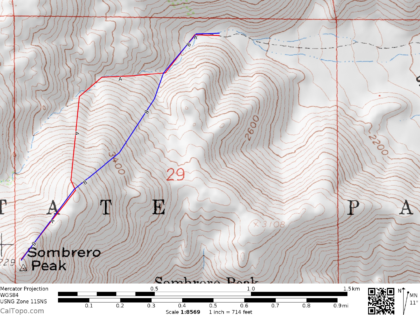
DRIVE/ROUTES A & B/NORTHERN APPROACH: See Map 1. From the Christmas traffic circle in
Borrego Springs, CA. drive 5.3 miles S on Borrego Springs Road to County Highway S3. Turn right (S)
here and go 6.9 miles to State Highway 78, where you'll turn right (W) and drive 6.7 miles to Scissors
Crossing. Turn left (S) on County Road S2, driving 29.5 miles to the signed Indian Valley Road (This good
dirt road is about 2.0 miles N of the Bow Willow Campground turnoff). Turn right (SW) and drive 2.5
miles to a fork. Bear left and go 2.8 miles to road's end at a small palm grove.
DRIVE/ROUTES A & B/SOUTHERN APPROACH: See Map 1. From Interstate 8 at Ocotillo, CA. drive
18 miles N on County Highway S2 to the signed Indian Valley Road (This good dirt road is about 2.0 miles
N of the Bow Willow Campground turnoff). Turn left (SW) and drive 2.5 miles to a fork. Bear left and go
2.8 miles to road's end at a small palm grove.
CLIMB/ROUTE A: Hike up the wash behind the palm oasis for about 0.5 miles to the 2700 foot level.
Turn left (SSW) here, ascending the ridge to point 3840+, then SSW to the summit. The last 0.2 miles to
the top is rather brushy in spots and might require some bushwhacking.
CLIMB/ROUTE B: From the parking area, climb SSW up a chute which leads to a flattish area at 2900
feet elevation near UTM 673335. From here climb SW over point 3840+ on your way to the summit.
ROUND TRIP STATS/ROUTE A OR B: 2100 feet of elevation gain, 3 miles, 3-4 hours
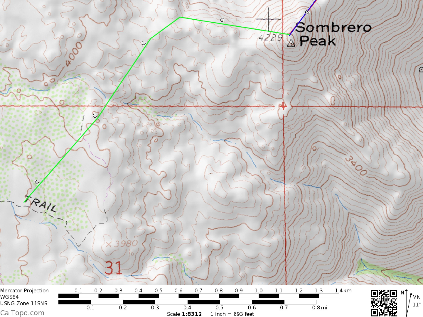
DRIVE/ROUTE C: See Map 2. This is the easiest driving approach to Sombrero Peak, requiring only a
2WD vehicle. About 54 miles E of San Diego (50 miles W of El Centro, CA) leave Interstate 8 at the State
Highway 94, Campo Boulevard exit. At the offramp stop sign turn right (sign here "McCain Valley State
Rec. Area, 7 miles") and drive 0.4 miles to a 4-way intersection. Turn left (E) and go 1.8 miles to the
signed, paved McCain Valley Road. Turn left (N) and drive 2.3 miles to the end of pavement at a cattle
guard and a
large BLM sign welcoming you to McCain Valley, en route passing under Interstate 8. Continue driving
0.35 miles N on good dirt to a junction and sign "Cottonwood Campground 10 miles". Staying straight (N)
here and ignoring all minor road forks, follow the good dirt road 9.9 miles to a cattle guard and sign
"Cottonwood Recreation Site" at a 3-way fork. Park off the road in this area.
CLIMB/ROUTE C: From the 3-way fork take the right branch, hiking E 0.2 miles to a sign "Pepperwood
Trail; Pepperwood Spring 4.2 miles, Sombrero Peak 5.0 miles". This is the trailhead for Sombrero Peak.
Follow this trail 2.0 miles N to a point near UTM 633315, where you'll leave the trail and head generally E
0.75 miles to a shallow saddle just N of point 4553. Continue ENE over the saddle for about 1.5 mile to the
W ridge of Sombrero, turning right (E) and following it to the summit. NOTE: Sombrero Peak is not
visible along a large portion of this route. Be prepared to use your route-finding skills on this dayhike.
ROUND TRIP STATS/ROUTE C: 1100 feet elevation gain, 10 miles, 6 hours
CLIMB ALTERNATE ROUTE: From the A/B parking area, follow route A to the end of the wash at
2700’. Turn left and look for a faint use trail heading up the left side of the drainage across from the ridge
the A route follows. Take this path to a flattish area above, and join route B over point 3840+, continuing
to follow the faint path. It will end just below the summit boulders. An easy scramble will put you on top.
EGO AND IMPERIAL COUNTY RANGES GUIDE NO. 5.2
SOMBRERO PEAK (CONTINUED)
SIDELINES
1. Bow Willow Campground, located 1.7 miles W of County Highway S2 offers convenient
overnightcamping for those doing Routes A or B on Sombrero Peak. This State Park campground is open
all-year and has 16 sites with picnic tables and fire rings as well as community pit toilets. Drinking water
is also available. There is a fee for overnight camping.
2. Cottonwood Recreation Site is an all-year BLM campground located at 3800 feet elevation near
thetrailhead for Route C. It has 25 sites with picnic tables and fire rings as well as community pit toilets.
Drinking water is piped to faucets throughout the campground. There is a fee for overnight camping.
This is a popular site where privacy may be hard to find. The most secluded sites seem to be at the far
eastern side of the campground near the trailhead for Route C.
3. Primitive camping may also be found at the trailhead for small parties.