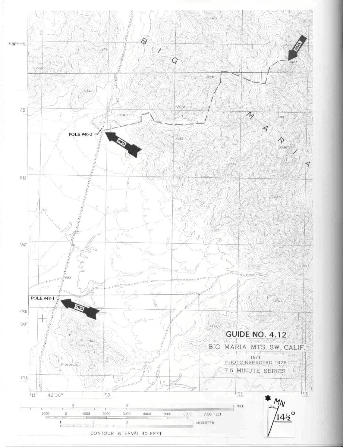
4 RIVERSIDE COUNTY RANGES GUIDE NO. 4.12
BIG MARIA MOUNTAIN 3381 FEET CLASS 1
MILEAGE: 250 miles of paved road, 4 miles of fair dirt, 1.7 miles 4WD dirt road
DRIVE: Exit Interstate 10 at Lovekin Blvd. in Blythe, CA and drive approximately 5 miles N on the
boulevard to where it turns NW, crosses a set of railroad tracks and is called Midland Road. From the railroad
tracks drive 8.5 miles to where the Midland Road passes under N-S running high voltage power lines. Turn
right (N) here on a fair dirt road (BLM "brown stake" road P3020) that parallels the power lines on their W
side, following it for 4.0 miles to power pole #48-1. 2WD vehicles (most passenger cars) will probably want
to stop and park here. Just N of pole #48-1 is the first of four or five bad spots on the road that could tear the
underside out of a passenger car or, at the very least, trap you solidly in boulders or a sand wash. Those
2WD's that choose to continue beyond pole #48-1 should be aware that the "bad spots" seem to get worse the
further N you travel. 4WD's can continue N along the power line road another 1.7 miles to pole #46-3,
reaching the starting point for this route.
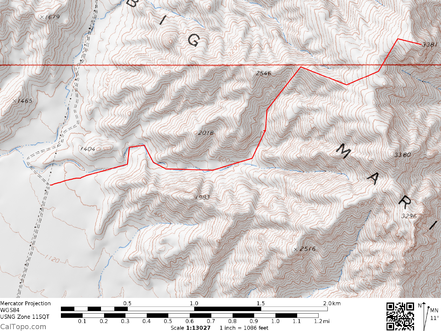
CLIMB: From pole #46-3 the peak is an unimpressive bump at a 68° bearing. Hike ENE at a 74° bearing
across rocky terrain to where you'll drop into a large wash heading generally E. Follow the wash along the S
side of point 2018 to its first major fork at 1600 feet elevation. Bear left, following the wash NNE to a second
large fork at 2000 feet elevation. Bear left, gaining about 550 feet of elevation to a saddle just NE of point
2546. Turn right (E) and follow the ridge for 0.5 miles to a saddle at 3000+ feet elevation. Turn left (N),
contouring around either side of two small bumps to the saddle 0.2 miles SW of the summit at 3040 feet
elevation. Head NE from here to the top.
ROUND TRIP STATS: 2300 feet elevation gain, 4.5 miles, 5 hours
SIDELINES
1. Other routes on Big Maria can be found by continuing N on the powerline road from pole #46-3. All
these routes will require some serious 4WDing on the powerline road and really don't gain you anything over
the route described above. For those tempted to follow the powerline road N all the way to US 95 at Vidal,
beware that you will encounter the Rice Sand Dunes en route. For environmental reasons, please don't drive
over this fragile desert landscape. If you really need to get to Vidal or Vidal Junction, return to the Midland
Road and take it N to the Blythe-Rice Road, which is followed N to State Highway 62 at Rice.
2. Big Maria Mountain is located within the boundaries of the Big Maria Mountains Wilderness Area. This
new wilderness area was created as a part of the California Desert Protection Act of 1994, Public Law 103-
433, Section 102 (4). The Big Maria Mountains Wilderness Area encompasses approximately 47,570 acres of
land and is managed by the Bureau of Land Management.