4 RIVERSIDE COUNTY RANGES GUIDE NO. 4.11
PALEN MOUNTAIN 3848 FEET CLASS 2
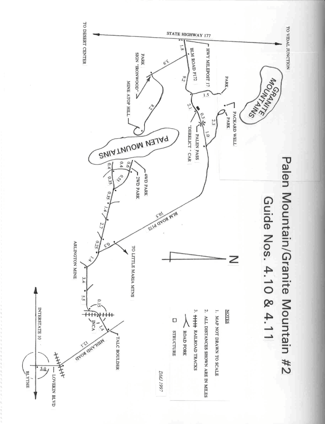
MILEAGE: 195 miles of paved road, 5.7 miles of sandy 4WD road
DRIVE/ROUTE A/WESTERN APPROACH: From Desert Center, CA drive 17 miles N on State Highway
177 to the Palen Pass
dirt road, located about 10 yards N of highway milepost 17. Turn right (E) and drive 1.8
miles of sandy road to a junction. Turn right and drive 3.9 miles to a fork with a fair dirt road coming in from
the east. Park. The boundary of the Palen-McCoy Wilderness Area is a few feet E of this parking spot.
NOTE: This is a very sandy route and should not be attempted with a 2WD vehicle. See the Palen
Mountain/Granite Mountain #2 road map included with this writeup.
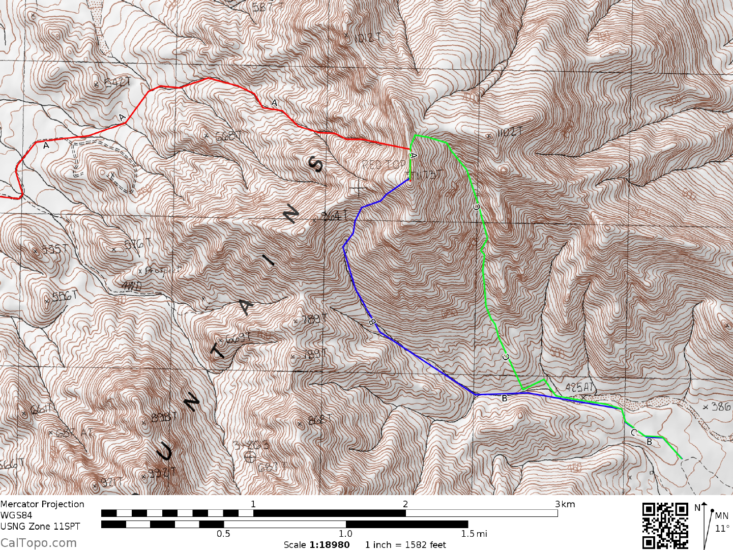
CLIMB/ROUTE A: Hike 8.2 miles E on the fair dirt road to the base of
the mountain. Leave the road just
before it curves right and climbs steeply
uphill to its end at a mine site. As a point of reference, the peak is
barely visible from here at a bearing of 93°, being nearly hidden by a prominent mass between it and the
viewer. From here hike 0.3 miles NE at a 28° bearing to a large wash. Dropping into the
wash, hike E
for about 200 yards to a fork. Bear left and walk 0.3 miles to a large fork from
which the peak can be seen at a
bearing of 114°. Bear right and hike 0.4 miles to another large fork, keeping left and following a narrow chute
to the summit ridge about 0.1 miles N of the peak. Turn right (S) and weave your way up the rocky crag (high
Class 2) to the summit.
ROUND TRIP STATS/ROUTE A: 3300 feet elevation gain, 20.5 miles, 14 hours
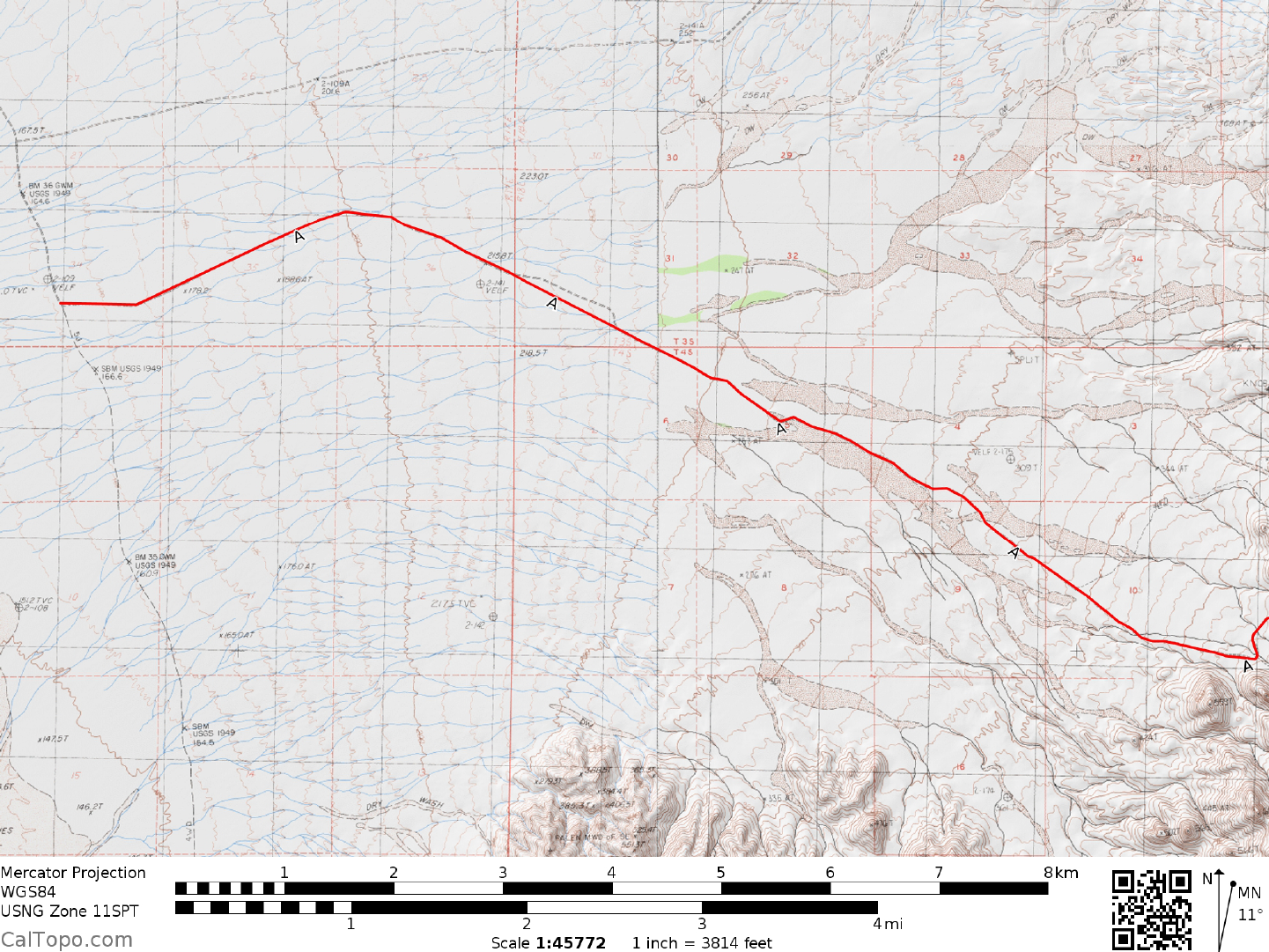
DRIVE/ROUTES B & C/EASTERN APPROACH: Exit Interstate 10 at Lovekin Blvd. in Bly
the, CA and
drive approxim
ately 5 miles N on the boulevard to where it turns NW, crosses a set of railroad tracks and is
called Midland Road. From the tracks drive 12.1 miles to a large white (talc) boulder on the left (W) side of
the road marking the turnoff to the railroad station of Inca. This turnoff is clearly shown on the AAA
Riverside County map. Turn left here on an excellent dirt road and in 100 feet take either fork (they rejoin just
before Inca) for 1.4 miles to the railroad crossing at Inca. Cross the tracks and bear left (S) on a good road
heading toward abandoned trailers and equipment. At a road fork in 0.15 miles bear right and follow the road
as it curves west. Disregarding all minor forks and junctions, stay on the main road (paved along certain
portions of its length), reaching a fork in 5.5 miles. Bear left and drive 3.4 miles to a fork. Bear right, driving
1.4 miles to a fork. Bear left (the right fork will take you to Palen Pass) and drive 0.25 miles to a fork. Keep
right and go 2.7 miles on fair dirt to a fork. Bear right, driving 1.4 miles on a progressively deteriorating road
to a junction. Continue straight 0.35 miles to a fork in a rocky wash. You can go either way here since the
roads are connected further ahead (see attached map), but it seems easiest to bear right, driving 0.55 miles to a
fork. Keep right, continuing another 0.2 miles to where the road drops steeply into a large wash. High
clearance 2WD’s should park off the road just before it drops into this large wash. 4WD’s can continue
another 0.4 miles, but parking and turnaround space is limited. As a navigational check, if you’re at the
corre
ct 2WD parking spot you’ll see an abandoned shack in the wash about 0.25 miles away at a 173° bearing
and Palen Mountain at a 320° bearing.
PALEN MOUNTAIN (CONTINUED)
4 RIVERSIDE COUNTY RANGES GUIDE NO. 4.11
CLIMB/ROUTE B: From the 2WD parking spot walk WNW up the road for 0.4 miles to the 4WD parking
spot. Continue 0.5 miles W up the canyon to a fork. Bear right (WNW) and hike 0.5 miles to a second fork.
Bear right again, following this canyon NW to a saddle at about 920 meters (3020 feet) elevation located 0.1
miles NE of Point 964. Turn right (NE) and follow the ridge to the rocky highpoint.
ROUND TRIP STATS/ROUTE B: 2600 feet elevation gain, 5 miles, 5-6 hours
CLIMB/ROUTE C: From the 2WD parking spot identify
the whitish rock chute to the NW at bearing 320°
and the prominent pinnacle at 325°. These landmarks
are navigational aids for this route. Walk 0.4 miles
WNW up the road to the 4WD parking spot and drop into the wash on your right. Hike up the wash to the
whitish rock chute identified earlier. Ascend to its upper end, where you'll bear right (NNW) up a steep chute
to the left of the previously identified prominent pinnacle. Climb the chute to a saddle located 0.25 miles NE
of the summit at 1060+ meters (3480+ feet) elevation. Turn left, gain the summit ridge and head left (S) to the
rocky highpoint.
ROUND TRIP STATS/ROUTE B: 2600 feet elevation gain, 4 miles, 4-5 hours
SIDELINES
1. Included as part of Guide No. 4.10 is a road map that should prove useful in finding y
our way
to the
climbing routes on both Palen Mountain and Granite Mountain #2.
2. Palen Mountain is located within the boundaries of the Palen-McCoy
Mountains Wilderness. This new
wilderness area was created as part of the California Desert Protection Act of 1994,
Public Law 103-433,
Section 102 (47). The Palen-McCoy Mountains Wilderness Area encompasses approximately 270,629 acres
of land and is managed by the Bureau of Land Management (BLM).
Revised 2/6/18