8 RIVERSIDE COUNTY RANGES GUIDE NO. 4.10
GRANITE MOUNTAIN #2 4331 FEET CLASS 2
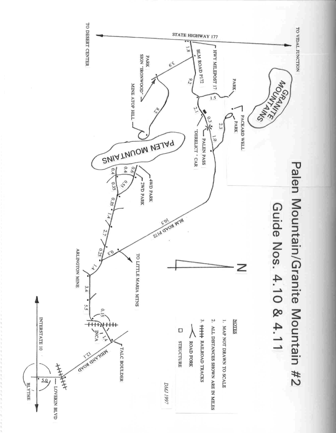
MILEAGE: 195 miles of paved road, 15.5 miles of poor, sandy, 4WD road.
***This WESTERN DRIVE route is NOT recommended as multiple washes have cut deeply crosswise on
this access route. While DRIVE/ROUTE A EASTERN APPROACH is longer, the road is much better and
is the recommended drive route, Jeep-type vehicles excepted.
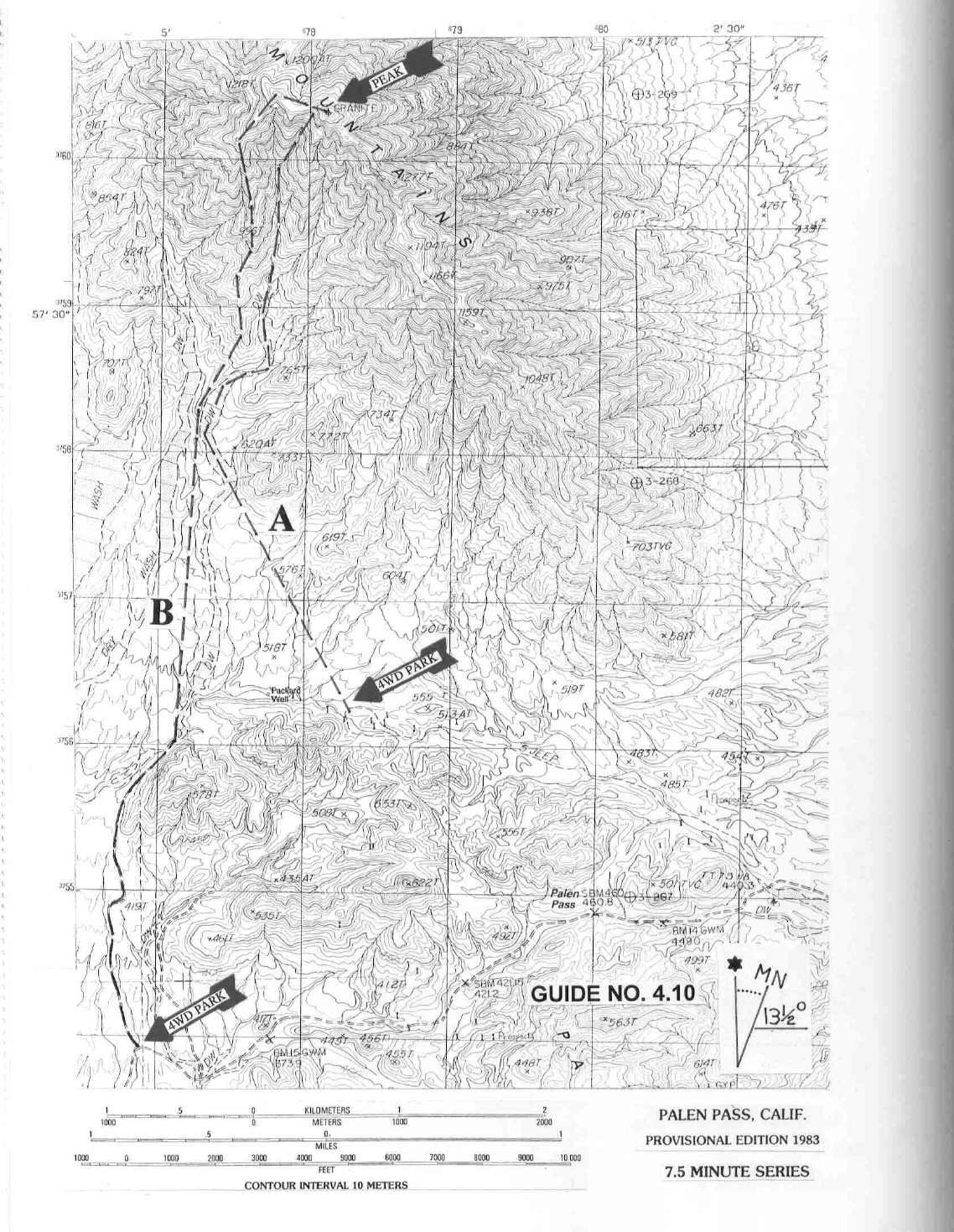
DRIVE/ROUTE A/WESTERN APPROACH: From Desert Center, CA drive 17 miles N on State Highway
177 to the Palen Pass dirt road, located about 10 yards N of highway milepost 17. Turn right (E) and drive
1.8 miles of sandy road to its junction with a dirt road coming in from the right. Continue straight (E) 11.4
miles to a good dirt road turnoff heading left (NW), en route passing a derelict car (at 9.7mi) in a wash on
the left and crossing over Palen Pass (NOTE: For details see Palen Mountain/Granite Mountain #2 road
map in Guide Section 4.11, Palen Mountain. This western approach to Palen Pass from State Highway 177
can be very rough, with large washouts cutting across the road making high-clearance 4WD vehicles a must.
Besides that, the first two miles or so in from the highway are extremely sandy and can easily trap a 2WD
vehicle.). Turn left and drive 0.1 miles to a fork. Bear left and go 0.45 miles, where the road drops into a
deep wash and out the other side. Continue 0.4 miles to where the road once again drops into the wash.
Park in this area. It is not possible to take anything other than a Jeep or motorcycle farther.
CLIMB/ROUTE A: From the vehicles at the parking spot described above, follow the road up the wash for
about 200 feet to where a road climbs steeply up the left bank out of the wash, but don’t go up it. Continue
up the wash another 0.1 miles to where a somewhat easier road exits the wash along its left bank. Once out
of the wash, continue heading generally W for 0.85 miles to a fork. Bear left and continue 0.4 miles to a
large flat area on the right. Packard Well is about 0.25 miles further W and marks the boundary of the Palen-
McCoy Wilderness Area.
From the flat area mentioned above, the peak is visible at a bearing of 3°. Hike 1.0 mile at bearing 338° to
the SW side of hill 733 adjacent to a large, boulder strewn wash. Dropping into the wash, hike up it for
about 0.1 miles to a fork. Bear left, following the main wash for about 0.6 miles to a fork at the 700 meter
(2300 foot) elevation level, where you'll bear left again up the main wash. In 0.25 miles keep left at a fork,
following that branch up to 1000 meters (3280 feet) elevation and yet another fork. Take the right fork here
up to the summit ridge 0.1 miles W of the peak. En route to the summit ridge you'll encounter a 25 foot
high, Class 4 dry waterfall which can be bypassed on the right. Upon reaching the summit ridge, turn right
(E) and walk to the top. Descending from the peak you can either retrace your ascent route or hike 0.25
miles W from the summit and follow the ridge down over point 996 to the base of the mountain. Rejoin
Route A in the large wash to the E and retrace your steps from there back to Packard Well and beyond to
the vehicles.
ROUND TRIP STATS/ROUTE A: 3200 feet elevation gain, 11 miles, 8-9 hours
8 RIVERSIDE COUNTY RANGES GUIDE NO. 4.10
***This WESTERN DRIVE route is NOT recommended as multiple washes have cut deeply crosswise on
this access route. While DRIVE/ROUTE B EASTERN APPROACH is longer, the road is much better and
is the recommended drive route, Jeep-type vehicles excepted.
DRIVE/ROUTE B/WESTERN APPROACH: From Desert Center, CA drive 17 miles N on State Highway
177 to the Palen Pass dirt road, located about 10 yards N of highway milepost 17. Turn right (E) and drive
1.8 miles of sandy road to its junction with a dirt road coming in from the right. Continue straight (E) 8.1
miles to where the road makes a 90° bend from N to E at UTM 769539. Park. (NOTE: For details see Palen
Mountain/Granite Mountain #2 road map in Guide Section 4.11, Palen Mountain. The approach to Palen
Pass from State Highway 177 can be very rough, with large washouts cutting across the road making high-
clearance 4WD vehicles a must. Besides that, the first two miles or so in from the highway are extremely
sandy and can easily trap a 2WD vehicle.) The faint road heading N from here is within the boundaries of
the Palen-McCoy Wilderness Area and is off-limits to vehicular traffic.
CLIMB/ROUTE B: Hike 1.5 miles (N) up the poor dirt road to its end at UTM 770559, about 0.25 miles
NW of hill 528. Head N for 1.75 miles to the base of the mountain along the high ground that separates the
two large washes that run N-S from the peak. From here head N on the ridge over point 996 to gain the
summit ridge about 0.25 miles W of the peak. Turn right (E) and climb to the top. Descending from the
peak you can either retrace your ascent route or hike to the saddle just W of the summit and drop down the
gully just E of the ridge you ascended, following it to the large wash at the base of the mountain. Exit right
to the high ground W of the wash and retrace your steps S to the vehicles.
ROUND TRIP STATS/ROUTE B: 3200 feet elevation gain, 9 miles, 7-8 hours
DRIVE/ROUTES A & B/EASTERN APPROACH (Recommended Drive approach): The starting points
for Routes A and B on Granite Mountain #2 can be driven to from the east. If you're doing Palen Mountain
and also plan to climb Granite #2, then it might make more sense to approach the range from the east side.
Keep in mind that a 4WD vehicle may be needed for some of the sandy spots encountered on this eastern
approach. (NOTE: For details see Palen Mountain/Granite Mountain #2 road map in Guide Section 4.11,
Palen Mountain) Exit Interstate 10 at Lovekin Blvd. in Blythe, CA and drive approximately 5 miles N on
the boulevard to where it turns NW, crosses a set of railroad tracks and is called Midland Road. From the
tracks drive 12.1 miles to a large white (talc) boulder on the left (W) side of the road marking the turnoff
to the railroad station of Inca. This turnoff is clearly shown on the AAA Riverside County map. Turn left
here on an excellent dirt road and in 100 feet take either fork (they rejoin just before Inca) for 1.4 miles to
the railroad crossing at Inca. Cross the tracks and bear left (S) on a good road heading toward abandoned
trailers and equipment. At a road fork in 0.15 miles bear right and follow the road as it curves west.
Disregarding all minor forks and junctions, stay on the main road (paved along certain portions of its length),
reaching a fork in 5.5 miles. Bear left and drive 3.4 miles to a fork. Bear right, driving 1.4 miles to a fork.
Bear right (the left fork will take you to the start of Routes B and C on Palen Mountain, Guide No. 4.11)
and drive 0.3 miles to a fork. Bear left and go 0.8 miles to a fork. Bear left, following the sometimes sandy
road 8.6 miles NW then W to the turnoff (right side of road) for Route A. Follow Drive/Route A/Western
Approach directions about 0.8 miles from this turnoff to the parking spot near the wash. To reach the start
of Route B drive the Palen Pass road 3.3 miles W of the Route A turnoff to where it makes a 90° turn from
W to S at UTM 769539. Park.
8 RIVERSIDE COUNTY RANGES GUIDE NO. 4.10
SIDELINES
1. From the summit of Granite Mountain #2 you'll be able to see these landmarks at the following bearings:
Danby Dry Lake at 0°, Turtle Mtn. at 33°, Whipple Mtn. at 58°, Big Maria Mtn. at 108°, Kofa Peak at 127°,
Palen Mtn. at 171°, Packard Well at 183°, Black Butte at 207°, Mt. San Jacinto at 263°, Spectre Peak at
279°, Sheephole Mtn. at 295° and MWD's Iron Mtn. Pump Station at 349°.
2. As mentioned above, the western approach to Palen Pass from State Highway 177 is quite sandy for the
first 2 miles and very rough for many miles beyond that, posing a real problem for 2WD vehicles. The
eastern approach to Palen Pass from the Blythe area is very long and also has some sandy spots that can
also trap a 2WD vehicle. With that stated, it should be obvious that the safest way to tackle any approach
to Granite #2 is with a suitably equipped high-clearance 4WD vehicle. Also, the western approach is not
recommended except for Jeep-type vehicles due to the steep perpendicular cuts washes have made to what
is left of the road.
3. Granite Mountain #2 is located within the boundaries of the Palen-McCoy Mountains Wilderness. This
new wilderness area was created as part of the California Desert Protection Act of 1994, Public Law 103-
433, Section 102 (47). The Palen-McCoy Mountains Wilderness Area encompasses approximately 270,629
acres of land and is managed by the Bureau of Land Management (BLM).