4 RIVERSIDE COUNTY RANGES GUIDE NO. 4.8
CHUCKWALLA MOUNTAIN 3446 FEET CLASS 2
MILEAGE: 201 miles of paved road, 15.4 miles of good dirt, 1.5 miles of fair dirt, 0.3 miles of poor to
4WD road.
DRIVE: From Desert Center, CA. drive 9.3 miles E on Interstate 10 to the signed Corn Springs Road exit.
Turn right (S) at the off-ram
p stop sign and follow the paved, signed Chuckwalla Valley
Road eastward for 13
miles to the signed, excellent dirt Graham Pass Road. If you’re approaching from Blythe, CA on I-10, drive
approximately 22 miles W to the Ford Dry Lake offramp. Exiting here, drive S over the freeway to the signed
Chuckwalla Valley Road. Turn right (W) and drive 3.0 miles to the signed Graham Pass Road. Turn S,
bearing left at a fork in 5.7 miles. Continuing another 9.7 miles (over Graham Pass) to a faint dirt road
heading right or NW (marked #588). (As a navigational check here, 0.35 m
iles further W on the Graham
Pass Road will bring you to its junction with the Bradshaw Trail, signed SR301. A sign explaining the
features of the Chuckwalla Bench ACEC is posted at this intersection). Follow the faint dirt road NW for
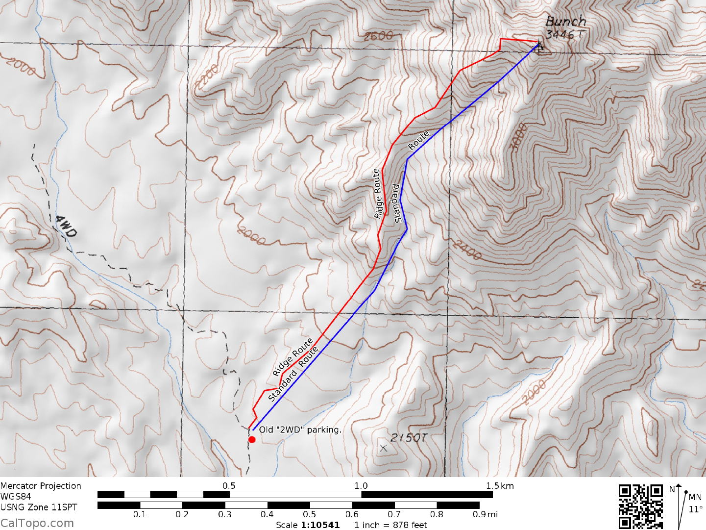
1.5 miles to ajunction where it makes a sharp left turn down into a rocky wash. 2WD's park here. 4WD's
turn right, continuing another 0.3 miles up a steep, rocky road to where it begins curving left. Park. Vehicle parking
and turnaround space is limited here. Note: road is over grown as of 11/20/17, so this may not be an option.
NOTE: This area is the site of a patented mining claim
. It would probably be wise
to park here only
for as long as it takes to do the peak.
Overnight camping is not
recommended in this area. (Follow up note: no signs of active mining were found on 11/20/17. A fire
was found at the 2WD parking area.)
DRIVE/ALTERNATE: If approaching Chuckwalla from
Black Butte via the Bradshaw Trail, proceed as
follows: From the junction of the Bradshaw Trail and the faint Black Butte dirt road turnoff (see BLACK
BUTTE, Guide No. 4.7, Drive/Approach A), drive E on the Bradshaw Trail 14.5 miles to its intersection with
the Graham Pass Road at the above-mentioned Chuckwalla Bench ACEC sign. Bear left on the Graham Pass
Road, driving 0.35 miles to a faint dirt road heading left (NW). Follow the faint dirt road 1.5 miles to a
junction where it makes a sharp left turn down into a rocky wash. 2WD's park here. 4WD's turn right,
continuing another 0.3 miles up a steep, rocky road to where it begins curving left. Park. Vehicle parking and
turnaround space is limited here.
CLIMB: From the 4WD parking spot, hike toward the m
ountain at a 75° bearing, dropping into a wash in
about 0.2 m
iles. Following the wash generally
N to the summit ridge, turn right (E) for a short walk to the
top. Summit views reveal Chuckwalla to be a surprisingly rugged desert peak from many sides.
ROUND TRIP STATS/4WD: 1500 feet elevation gain, 2.5 miles, 2.5 hours
ROUND TRIP STATS/2WD: 1600 feet elevation gain, 3.0 miles, 3 hours
Revised 11/14/17