4 RIVERSIDE COUNTY RANGES GUIDE NO. 4.7
BLACK BUTTE 4504 FEET CLASS 2
MILEAGE: 165 miles of paved road, 8.0 miles of excellent dirt, 12.9 miles of fair to poor dirt, 1.6 miles of
poor dirt road
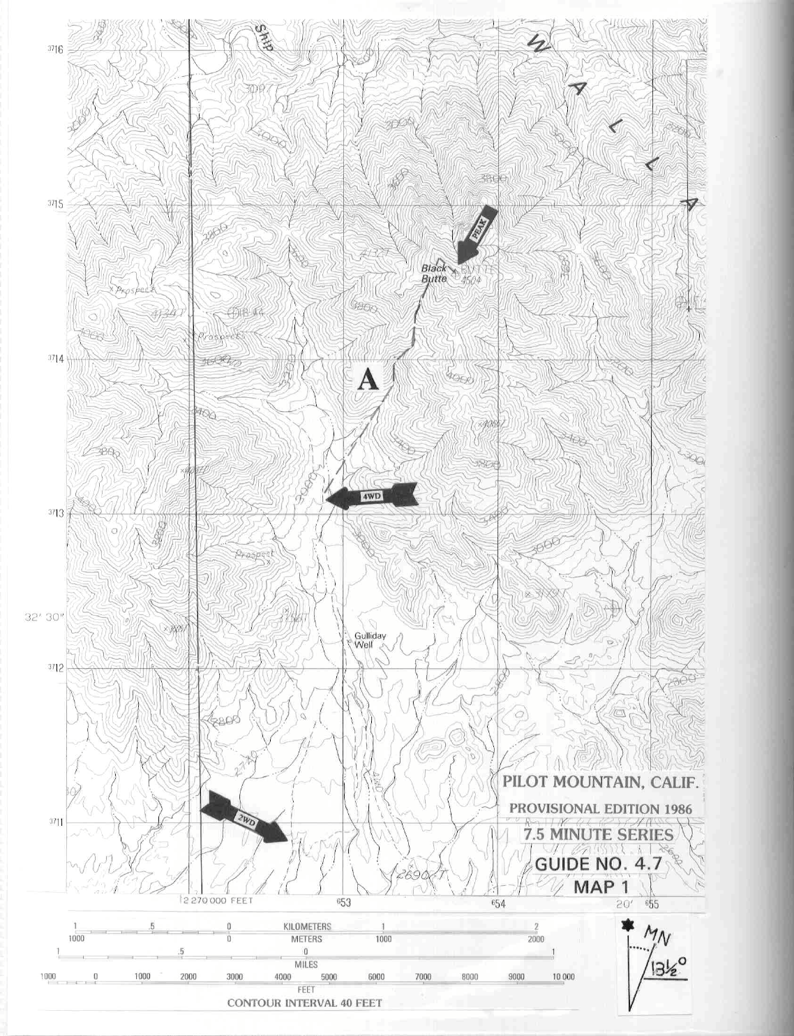
DRIVE/ROUTE A: From Chiriaco Summit drive 9 miles E on Interstate 10 to the Red Cloud Road exit.
From
the off-ramp stop sign drive straight
(S) on excellent dirt (signed BLM brown stake road C032), passing
under high voltage power transmission lines in 0.5 miles and continuing another 0.7 miles to a junction. Bear
right, driving 0.85 miles on fair dirt to a fork. Bear left here following light duty power lines on your left and
railroad tracks on the right for 0.15 miles to a fork. Bear left (lower road), following the power lines 0.95
miles to a fork. Bear right and drive 0.85 miles to the unsigned Gas Line Road. Turn right (S) and follow the
Gas Line Road (fair dirt with power poles on E side of road) for 7.7 miles to its junction with the signed
Bradshaw Trail Road. Turn left (E) on the Bradshaw Trail (excellent dirt) and drive 6.8 miles to a faint road
heading left (N) toward Black Butte (CM 480). This faint road is 0.4 miles E of a visible concrete slab located
20 y
ards S of the Bradshaw Trail. Follow this faint road 2.4 miles N to a junction. 2WD's park here. 4WD
high clearance vehicles can continue by bearing right, passing through a wash and continuing 1.3 miles to a road
fork. Bear right and drive 0.3 miles. Park.
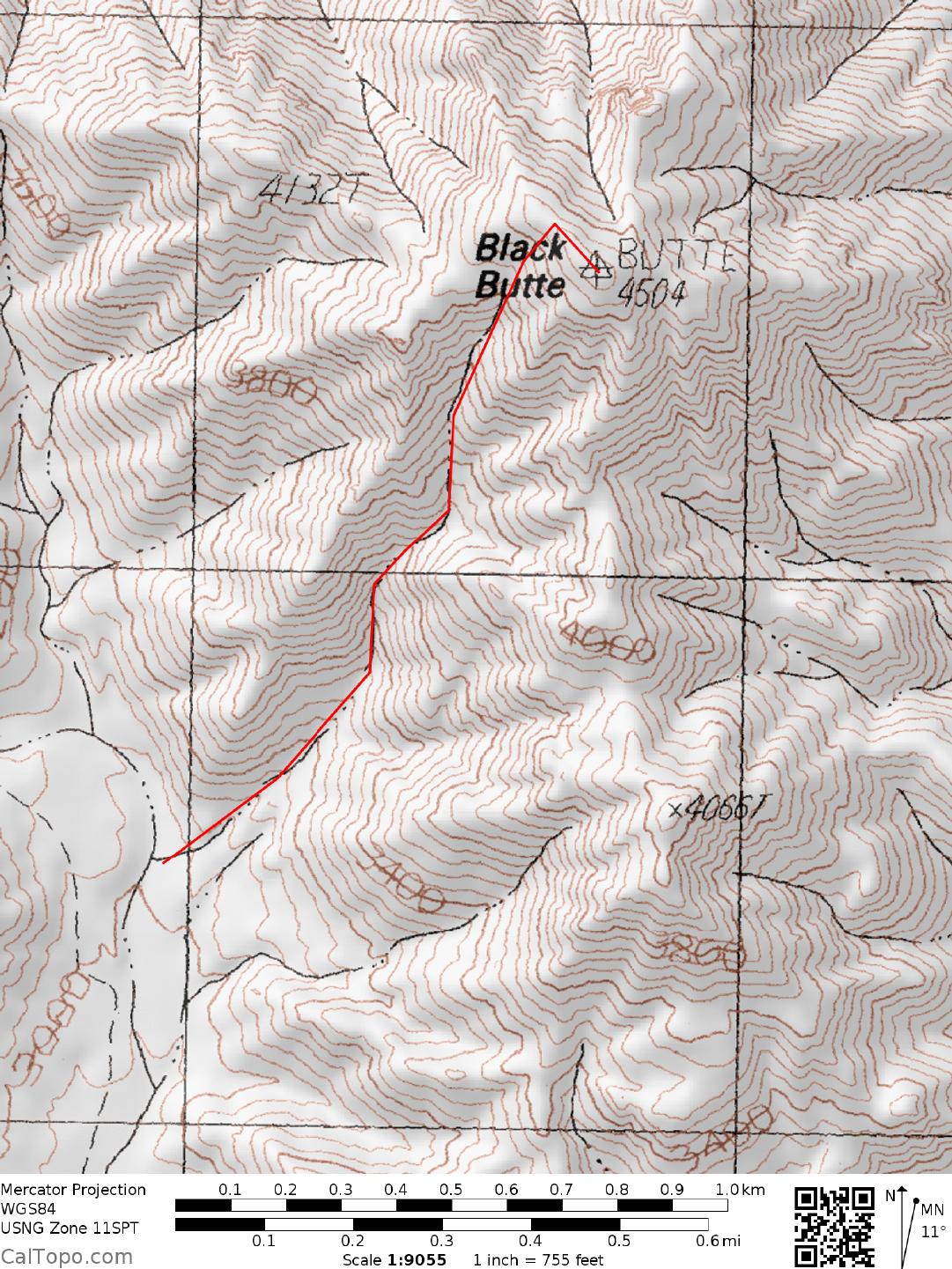
CLIMB/ROUTE A: See Map 1. Head toward the SW canyon of Black Butte at a 33° bearing, hiking up the
wash and keeping left at all m
ajor forks until
you gain the summit ridge at approximately the 4,300 foot level.
Turn right (SE) and walk to the summit.
ROUND TRIP STATS/4WD/ROUTE A: 1600 feet elevation gain, 3 miles, 2.5 hours
ROUND TRIP STATS/2WD/ROUTE A: 1830 feet elevation gain, 6.6 miles, 4 hours
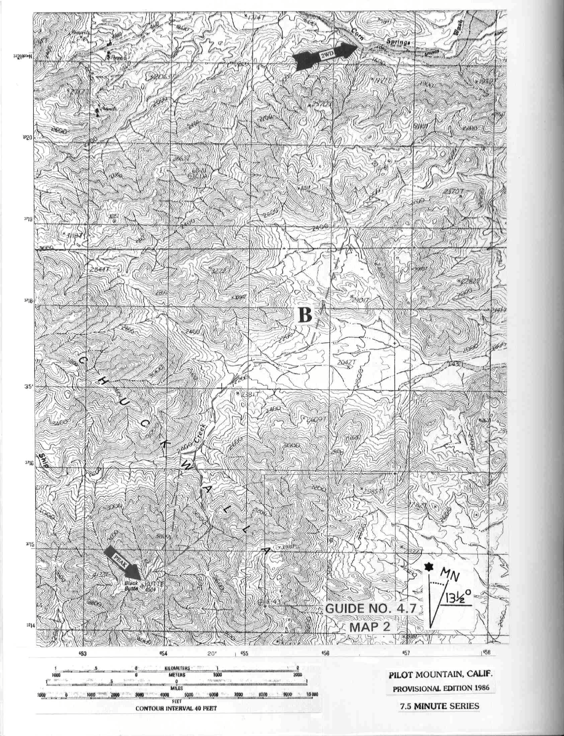
DRIVE/ROUTE B: From Desert Center, CA. drive 9.3 m
iles E on Interstate 10 to the Corn Springs Road
exit. Turn right (S) at the off-ramp stop sign and follow the
paved, signed Chuckwalla Road for 0.6 miles to
the signed Corn Springs Campground turnoff. Turning right (SW) here, follow the good dirt road for 6.3
miles to a spot just S of point 1841 at UTM 564213. Park.
CLIMB/ROUTE B: See Map 2. Scramble up the prominent
wash S of the parking spot to a saddle (UTM
560196)
E of point 3051. From here you can see Black Butte at a bearing of 203°. Drop SE down from the
saddle, following a wash to easier walking at the 2,200 foot level near UTM 562190. Hike SSW over rolling
terrain for about 1.0 mile to Ship Creek Wash. Follow this large wash 1.3 miles, first W then S to the 2,400
foot level at UTM 543162. From here climb the peak by either of the following routes: 1) Head S up a chute
located just right of Black Butte's N ridge. Following this chute to its end, gain the N ridge, which is taken to
the top, or 2) Hike the prominent wash heading S toward the saddle E of Black Butte. At the 3,000 foot level
the wash forks three ways. Take the far right fork up to easier slopes and the top.
ROUND TRIP STATS/ROUTE B: 4500 feet elevation gain (3800 in, 700 out), 12 m
iles, 8-9 hours
SIDELINES
BLACK BUTTE (CONTINUED)
4 RIVERSIDE COUNTY RANGES GUIDE NO. 4.7
1. The Bradshaw Trail is of historic significance in that it was used to haul supplies and gold between San
Francisco and Arizona in the 1860's and 70's. When the Southern Pacific Railroad was pushed through to
Yuma, AZ. in the 1870's, the trail no longer provided an economical means of transporting goods to the west
and soon fell into disuse.
2. The area S of the Chuckwalla Mountains, between the Chuckwallas and the Chocolate Mountains is
known as the Chuckwalla Bench. It has been recently
designated an ACEC (Area of Critical Environmental
Concern) because of the rich plant and animal life found in
the area. It is a prime habitat for the desert
tortoise, contains a small patch of rare desert grassland and is home to at least nine species of cactus, including
the treelike Munz cholla.
3. If you're climbing Black Butte by the northern route (Route B), plan on a side trip to the Corn Springs
oasis. The palm
oasis is located down the dirt road about a mile or so W of the parking spot for Route B.
Beside having a healthy stand of native palms, the area is also a prehistoric Indian site with m
any petroglyphs
on the surrounding rocks. There's a BLM fee campground here (1000 feet elevation) with 14 sites located
adjacent to the oasis. It is open year-round with facilities that include tables, fire rings, pit toilets and potable
well water from a hand pump.
4. Black Butte is located within the boundaries of the Chuckwalla Mountains Wilderness Area. This new
wilderness area was created as part of the California Desert Protection Act
of 1994, Public Law 103-433,
Section 102 (12). The Chuckwalla Mountains Wilderness Area encomp
asses approximately 80,770 acres of
land and is managed by the Bureau of Land Management (BLM).
5. Primitive camping spots may be found near both the 2WD and 4WD trailheads. There are no facilities.
Revised 11/23/17
4WD