4 RIVERSIDE COUNTY RANGES GUIDE NO. 4.6
OROCOPIA MOUNTAIN 3815 FEET CLASS 1
MILEAGE: 156 miles of paved road, 3.8 miles of good dirt, 0.4 miles of 4WD road
DRIVE/ROUTE A: See Map 1. From Indio, CA. drive 23 miles E on Interstate 10 to the signed Mecca-
Twentynine Palms exit. Turn right (S) and drive 0.35 miles to the paved, signed Pinto Road. Turn left
(E)
here and go 0.6 miles to a good dirt road heading S. Turn right (S), crossing under high voltage power lines in
0.95 miles and bearing left at the fork just past the power lines (MC 133). Continue 2.85 miles S to a junction,
bearing
left at all forks encountered along the way. Further progress is barred by a rock barrier across the sand
wash road directly S of this junction. 2WD's park here. 4WD's can continue by taking a sharp left up a steep
hill and going 75 yards to a fork. Bear right (S) at the fork and drive 0.4 miles to the Orocopia Mountains
Wilderness boundary. Park.
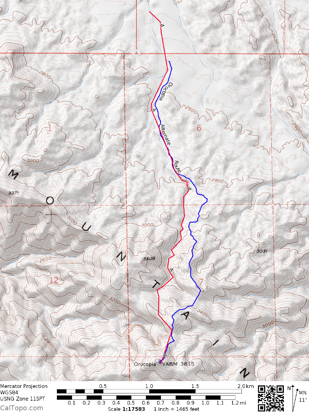
CLIMB/ROUTE A: See Map 1. From the 4WD parking area, walk 0.3 m
iles up the road to where
it passes
through a deep, narrow gully. Once across the gully, hike 0.5 miles S along the left bank of a large
wash.
Dropping into the wash here, follow it S for about 0.75 miles until you reach a fork with a large wash merging
from the right (W) at UTM 133157. At this point leave the wash and hike SSW up the ridge directly in front
of you. Near the crest of this ridge the peak will come into view. Either follow the ridgeline or contour
around the right (W) side of it to a saddle NNE of the peak. From here climb SSW to the broad summit of
Orocopia, where you'll have great views of the Salton Sea to the S, the San Jacinto and Santa Rosa ranges to
the W and the Chuckwallas to the E.
ALTERNATE ROUTE: At approximately 2800', angle left up to ridge above and find the use trail, following it
all the way to the
summit.
ROUND TRIP STATS/4WD/ROUTE A: 1100 feet elevation gain, 4.5 miles, 4 hours
ROUND TRIP STATS/2WD/ROUTE A: 1350 feet elevation gain, 5.5 miles, 5 hours
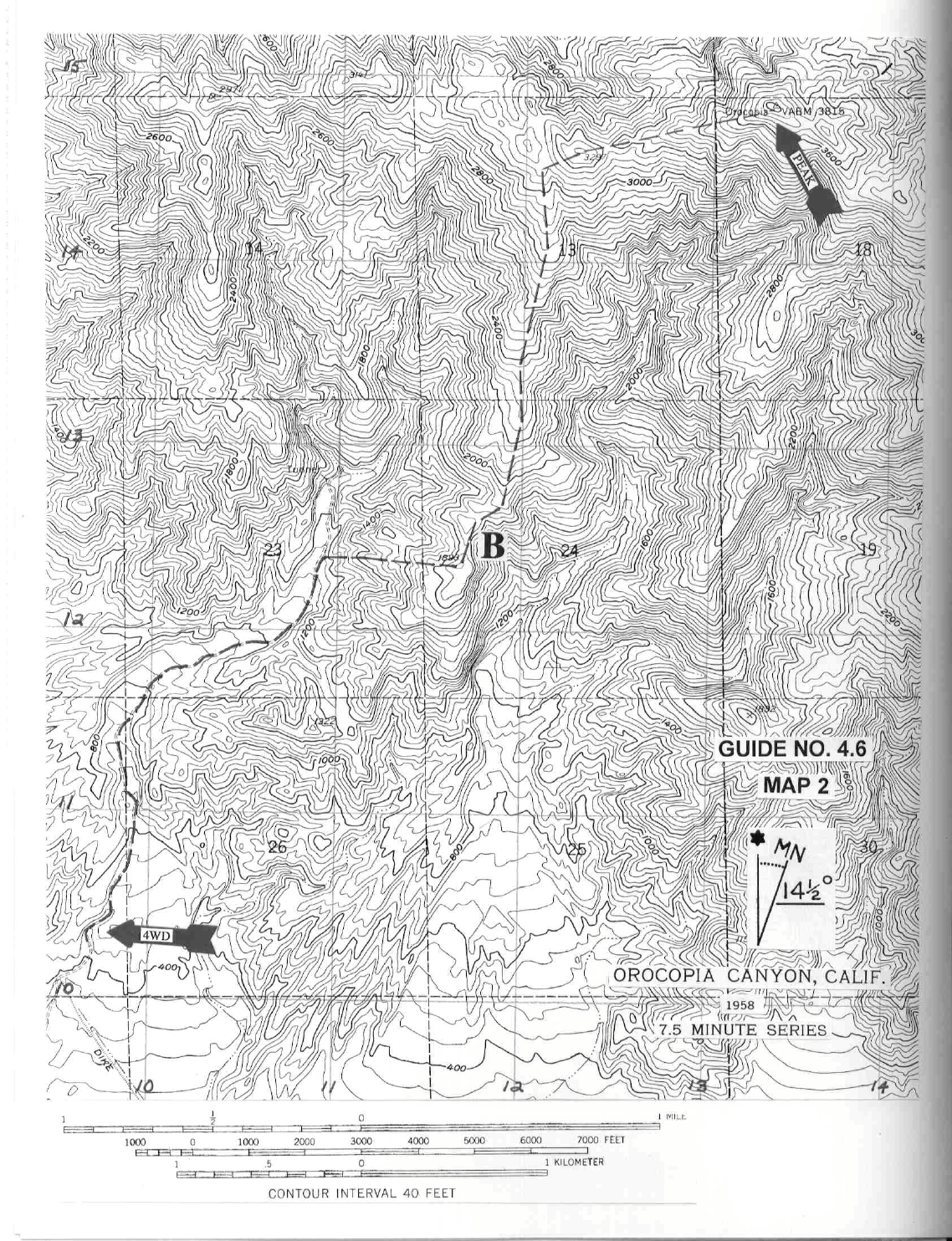
DRIVE/ROUTE B: See Map 2. From the intersection of State Routes 111 and 195 in Mecca, CA. drive 10.1
m
iles S
on SR 111 to signed Parkside Drive (0.3 miles S of highway
milepost 8.0), opposite the entrance to
the Salton Sea State Recreation Area. Turn left (E) here and go 1.7 miles to the road's end. Turn left (N) and
drive 0.5 miles on the signed Desert Aire Road (excellent dirt) to its end at an aqueduct. Turn right (E) on the
aqueduct frontage road and drive 3.5 miles to Siphon #28. Turn left (N) here on a high clearance 4WD mine
road, following it less than 1.0 mile to the Orocopia Mountains Wilderness boundary. 2.7 miles into a canyon
on Orocopia's S side. Park.
CLIMB/ROUTE B: See Map 2. Hike approximately 1.75 N up the mine road into a canyon on Orocopia’s S
side. Bearing right (E), ascend to the ridge line at point 1893. Turning left (N) here, follow
the ridge to point
3297, then 0.75 miles ENE to the summit.
ROUND TRIP STATS/ROUTE B: 3550 feet elevation gain, 9 m
iles, 8 hours
OROCOPIA MOUNTAIN (CONTINUED)

4 RIVERSIDE COUNTY RANGES GUIDE NO. 4.6
SIDELINES
1. Orocopia Mountain is located within the boundaries of the Orocopia Mountains Wilderness Area. This
new wilderness area was created as part of the California Desert Protection Act of 1994, Public Law 103-433,
Section 102 (44). The Orocopia Mountains Wilderness Area encomp
asses approximately 40,735 acres of
land and is managed by the Bureau of Land Management (BLM).
2. The name Orocopia is most probably a corruption of the Spanish “Oro Copa”, which m
eans gold cup. The
Orocopia Mountains are historically known as a gold m
ining area, with one of the largest opereators being the
Oro Copia Mining Company.
3. The area west of Orocopia Mountain contains many interesting sites for exploration, including Hidden
Spring and Sheep Hole Palm oases as well as a place known as the Grottoes. Widespread abuse of this unique
area by ORV’s over many years precipitated its inclusion as wilderness in the California Desert Protection Act
of 1994, Public Law 103-433, Section 102 (37). The area is know known as the Mecca Hills Wilderness area
and encompasses approximately 24,200 acres of land administered by the Bureau of Land Management
(BLM). A narrow dirt road corridor between this wilderness and the Orocopia Wilderness to the east is
seasonally closed to vehicular traffic in order to protect the well-being of a local bighorn sheep herd making a
comeback in the area after many years of marginal existence. For more information on exploring the Mecca
Hills Wilderness you might consider picking up the Sierra Club Book Adventuring in the California Desert by
Lynne Foster.
Revised 11/17/17
2WD
4WD