4 RIVERSIDE COUNTY RANGES GUIDE NO. 4.5
EAGLE MOUNTAIN #1 5350 FEET CLASS 1
MILEAGE: 178 miles of paved road
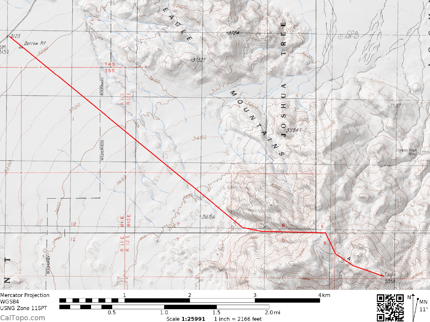
DRIVE/ROUTE A: From Indio, CA drive E approxim
ately 23 miles on Interstate 10 to the signed Mecca-
Twentynine Palms exit. At the offramp stop sign, turn left (N) on the signed Cottonwood Springs Road,
reaching the Joshua Tree National Park entrance station at Cottonwood Springs in 7.0 miles. A park entrance
fee must be paid here before continuing further into the Park (See SIDELINES 1 below). Continue N from
the entrance station on the Pinto Basin road for 2.4 miles to a dirt road turnoff on the right. This dirt road ends
in about 50 feet at a concrete barrier and some fence poles. Parking is very limited on this short dirt road; two
or three cars at the most. All others will have to park along the shoulder of the paved Pinto Basin Road.
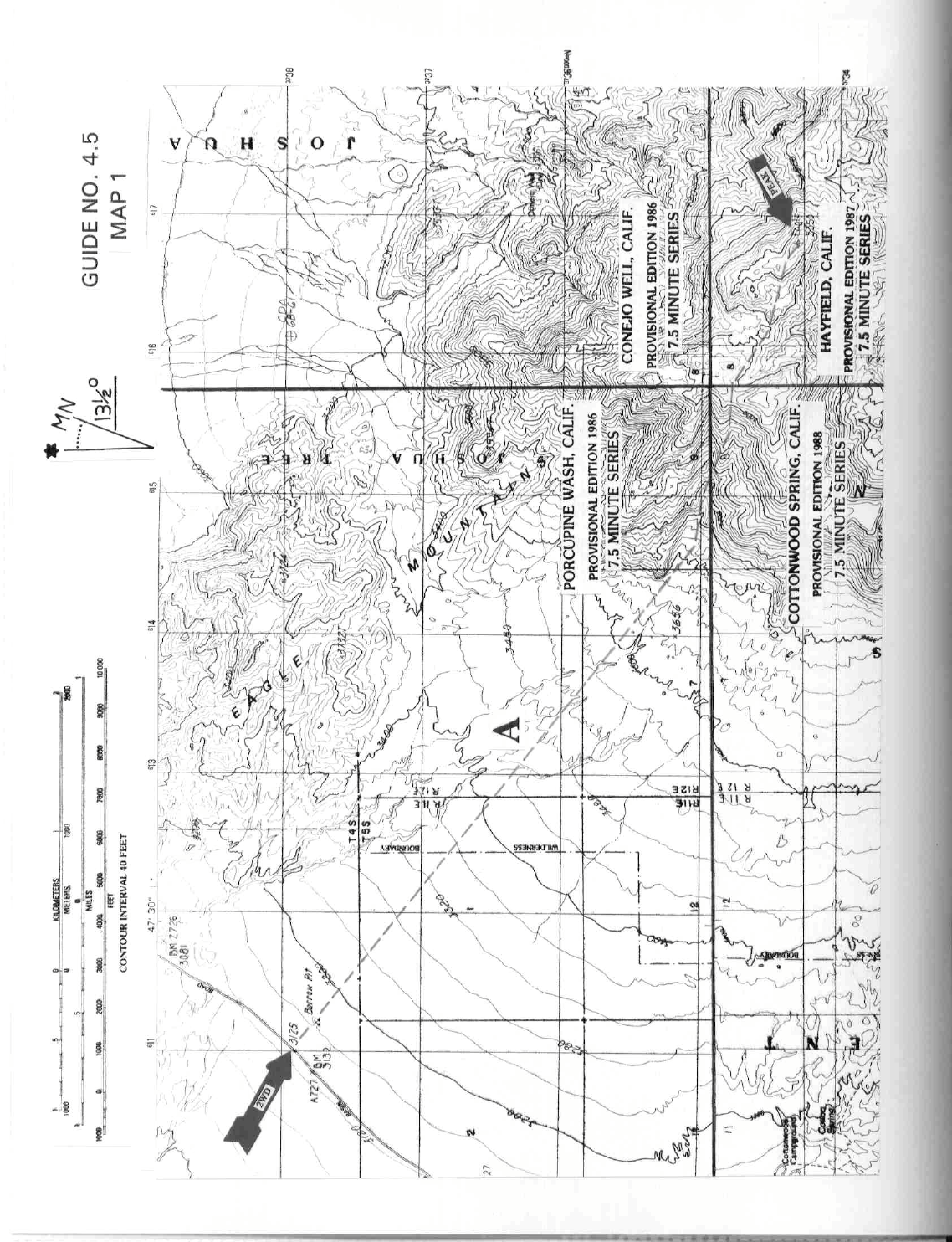
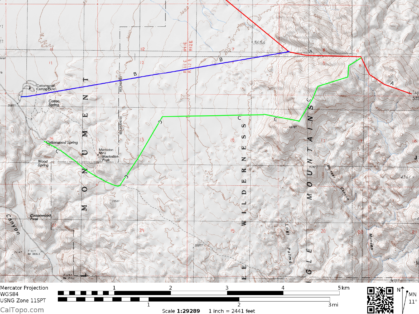
CLIMB/ROUTE A: See Map 1. From the end of the dirt road locate a grouping of large, rounded boulders at
the base of the m
ountain at a bearing of 130°. Hike this bearing for about 3 miles across the desert flats to the
boulders, which are located at the mouth of a large canyon. Hike up this canyon to about the 4200 foot
elevation level, bearing right into a gully which is followed to a notch at 5040 feet elevation (UTM 157348).
From this notch the peak can be seen at a bearing of 115°. Hiking along that bearing (ESE), drop about 150
feet in 0.3 miles to where you'll gain the summit ridge and follow it to the top.
ROUND TRIP STATS/ROUTE A: 2400 feet elevation gain, 9 miles, 6 hours
DRIVE/ROUTE B: Follow DRIVE/ROUTE A directions to the Joshua Tree National Park entrance station at
Cottonwood Springs. Turn right here on the signed, paved road to the Cottonwood Springs
campground.
Driving 0.7 miles to the signed turnoff for the campground, turn left, entering the fee campsite area. It is
assumed in this writeup that you will be staying at one of the established sites since day use parking is not
available in this area. If you need day use parking only, it's probably best to park at the Cottonwood Springs
entrance station. Camping fees and regulations are discussed in SIDELINES below.
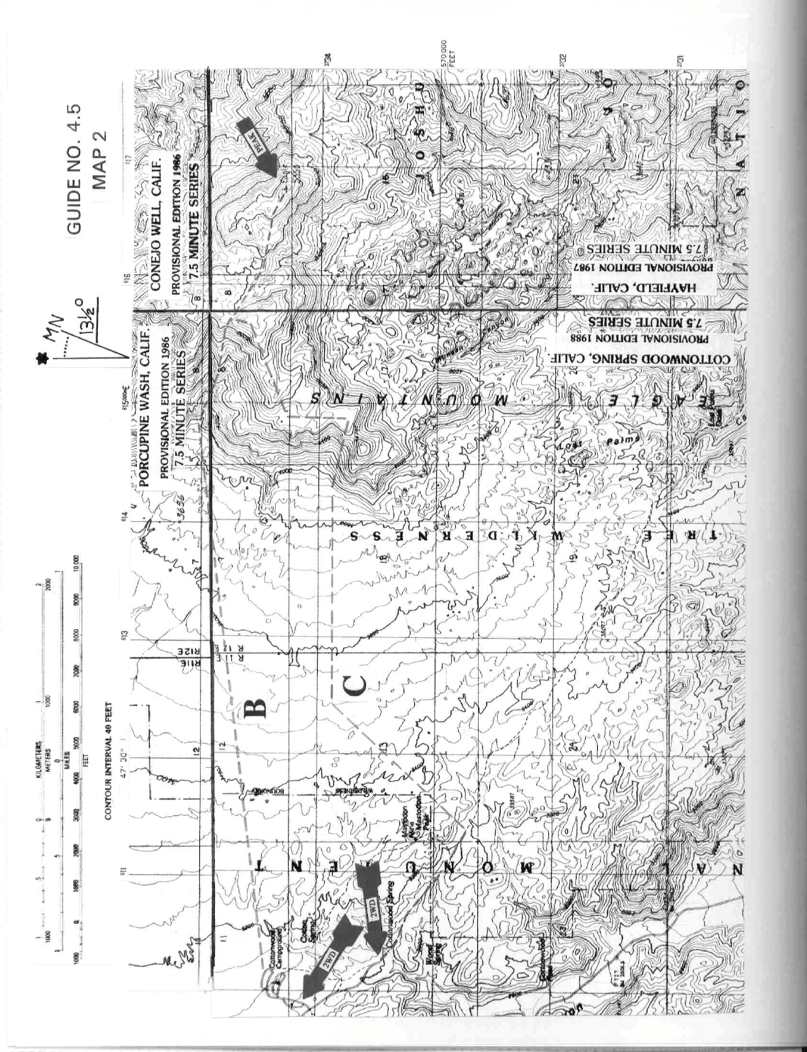
CLIMB/ROUTE B: See Map 2. The hike starts at the far end of cam
pground loop B at site #17. Walk cross
country at an 82° bearing through the low gap in the foreground hills, then on to the mouth of a large canyon
at the base of the mountain. Hike up this canyon to about the 4200 foot level and bear right into a gully which
is followed to a notch at 5040 feet elevation (UTM 157348). Follow ROUTE A from here to the top.
ROUND TRIP STATS/ROUTE B: 2400 feet elevation gain, 9 miles, 6 hours
DRIVE/ROUTE C: Follow DRIVE/ROUTE A directions to the Joshua Tree National Park entrance station at
Cottonwood Springs. Turn right here on the signed, paved road to the Cottonwood
EAGLE MOUNTAIN #1 (CONTINUED)

4 RIVERSIDE COUNTY RANGES GUIDE NO. 4.5
Springs campground. Drive 0.7 miles to the signed turnoff for the campground but, instead of turning left
here, continue straight for another 0.5 miles to the road's end at a large paved parking lot.
CLIMB/ROUTE C: See Map 2. At the E end of the parking lot find the trailhead to Mastodon
Peak
and Lost
Palms Oasis. Hike 1.0 miles SE on the trail to a location about 200 yards past the trail sign for Mastodon
Peak. Leaving the trail here, hike NE up a large wash for about 1.0 mile, then E to the base of the mountain.
Continuing E, ascend a gully to the ridgeline approximately 0.25 miles NE of point 4678. Follow the ridge N
then NE, staying mainly on its right side to the vicinity of the notch at 5040 feet elevation (UTM 157348).
Follow ROUTE A from here to the top.
ROUND TRIP STATS/ROUTE C: 2400 feet elevation gain, 10 miles, 6+ hours
SIDELINES
1. Joshua Tree National Park has an entry fee. Fees are collected at the three
m
ain entry points into the Park;
at the Twentynine Palms Visitors Center, an entrance station kiosk near Joshua Tree and at the Cottonwood
Springs entrance station. The entry permit is good for 7 days from the date of issue. Be aware that
unregistered vehicles (those without the permit affixed to the inside front windshield) are subject to citation
and/or towing.
2. Cottonwood Springs is a convenient place to camp when doing Eagle Mountain #1. The campground is
divided into two loops (A and B) with a total
of 60 sites and a group cam
pground with 3 sites. The loop A
and B sites are available for a modest fee. These sites are limited to six persons and two vehicles maximum
per site and are only available on a first come/first serve basis. The group sites are also available and are
limited to 12 people per site with a total of 35 available parking spaces for all three sites. Reservations for
group sites can be made by phone through Ticketron. All sites have fire rings, picnic tables and restroom
facilities with flush toilets and running water.
3. The Park has regulations which require that you register at a designated backcountry board before entering
the backcountry. The Park Service indicates that this is for your protection as well as a means of accruing
statistics for park administration. A complete list of backcountry regulations is available from the Main
Visitors Center, any of the entry stations or at the backcountry board where you must register before
beginning your hike.
Revised 3/10/18