4 RIVERSIDE COUNTY RANGES GUIDE NO. 4.2
RABBIT PEAK 6640+ FEET CLASS 2
MILEAGE: 152 miles of paved road
DRIVE/ROUTE A: Exit Interstate 10 just E of Indio, CA at Dillon Road and drive about 1.0 mile SW to its
intersection with State Highways 86 and 111. Turn left, driving S on State Highway 86 for 15.0 miles to the
signed Avenue 74/Fillmore Road junction. Drive S on Fillmore Road for 2.5 miles to its end at a levee. Park.
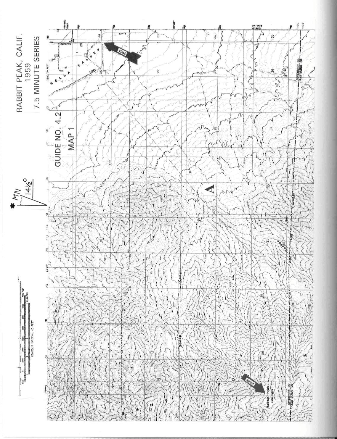
CLIMB/ROUTE A: See Map 1. Hike S over the levee and into the sandy wash just beyond. Turn right (W)
and hike about 0.5 miles in the wash to where you'll intersect a dirt road. Turn left (S) on this road, following
it about 100 yards (citrus trees on the right) to a second levee. Turning right (W) here, hike about 0.25 miles
(citrus trees on the right again) to an old jeep road which is followed SW for about 0.5 miles across the desert
flats to the start of a nicely ducked trail. Follow this trail, marked with numerous white rocks for about 3.0
miles to the base of a ridge which separates Sheep and Barton Canyons. Continue on the trail, gaining the
ridge line at the 1800 foot elevation level. Climb SW up the ridge for 1.5 miles to a large flat area just W of
point 3235. From here head W up the ridge, skirting around some rocky areas to the gently sloping summit
plateau of Rabbit. As would be expected, the highpoint of Rabbit and the summit register are located on the
furthest rock outcropping near the western edge of the plateau.
ROUND TRIP STATS/ROUTE A: 6700 feet elevation gain, 16 miles, 12-14 hours
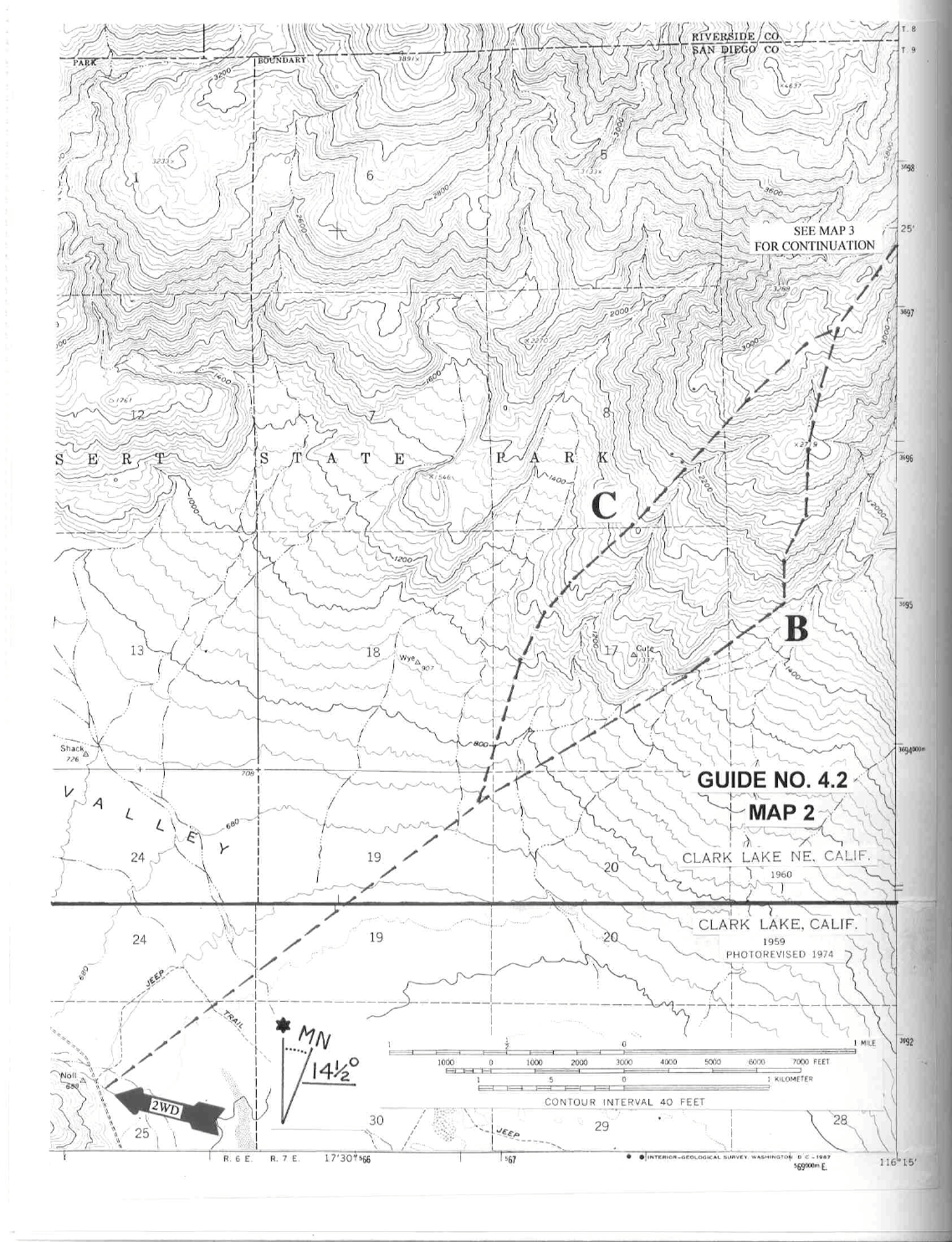
DRIVE/ROUTES B AND C: From Indio, CA drive 34 miles S on State Route 86 along the W shore of the
Salton Sea to Salton City, CA. Turn right (W) here on County Highway S22 and drive about 21 miles to the
Rockhouse Truck Trail. (If approaching from the W, the Rockhouse Truck Trail is about 7.2 miles E of the
traffic circle in Borrego Springs or 0.5 miles E of the Pegleg Smith Historical Monument). Follow the road
5.1 miles N a spur road heading E. Continue N another 0.3 miles, parking at a wide, hard dirt area near UTM
643915.
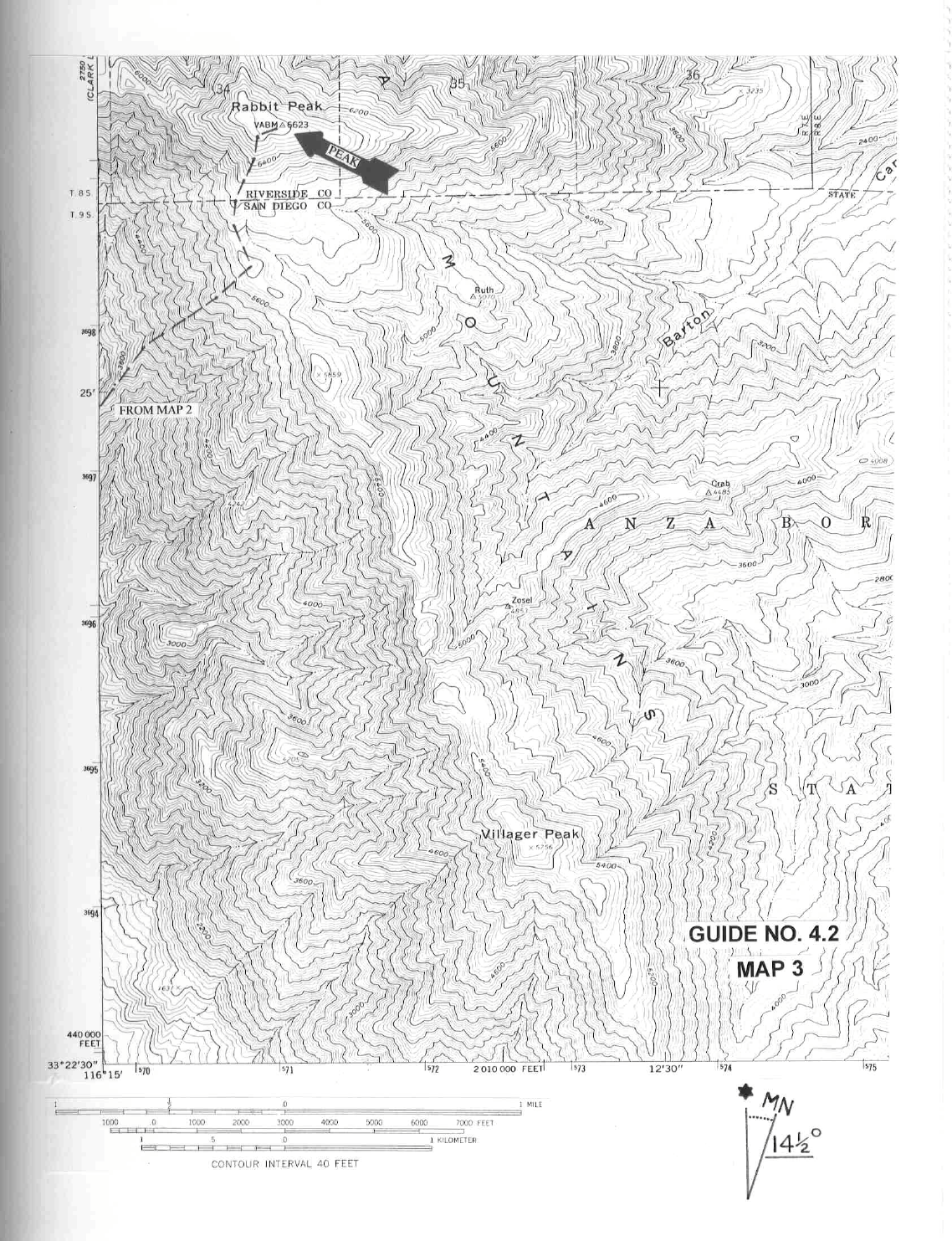
CLIMB/ROUTE B: See Maps 2 & 3. Hiking 2.5 miles NE across the desert at about a 50° bearing, bear
slightly left (N), gaining a broad ridge which is followed to near point 2719. From here head NE for 1.0 mile
to a saddle at 3300 feet (UTM 696973), en route intersecting the top of Route C at the 3200 foot elevation
level. Now climb steeply NE up the ridge to the crest of the Santa Rosa Mountains, topping out at a saddle
near 5800 feet elevation. Turn left, heading generally N along the crest to the summit plateau of Rabbit and
the rock outcropping that marks the highpoint.
ROUND TRIP STATS/ROUTE B: 6200 feet elevation gain, 14 miles, 12-14 hours
CLIMB/ROUTE C: See Maps 2 & 3. Hike 2.0 miles NE across the desert at about a 50° bearing. Head NNE
at a 20° bearing, gaining a ridge which is followed NE about 2.5 miles to rejoin Route B at the 3200 foot
elevation level. Follow Route B directions from here to the summit.
RABBIT PEAK (CONTINUED)
4 RIVERSIDE COUNTY RANGES GUIDE NO. 4.2
ROUND TRIP STATS/ROUTE C: 6200 feet elevation gain, 14 miles, 12-14 hours
SIDELINES
1. Rabbit Peak is perhaps the most strenuous day hike in this guide. There is no water to be found along
either Route A or B. You must carry enough with you to meet the demands of this grueling climb; 3 or 4
quarts of water minimum per person is recommended. Also, you've got to pick the right time of year to climb
the peak. A favorite time among DPS'ers is during the cool winter months of December, January and
February. Because of the short daylight hours during winter, be sure that all members of the group carry a
flashlight or headlamp (with extra batteries and bulb) for a possible return to the cars in the dark.
2. Some parties may opt to do Rabbit as an overnight backpack along Route A. Campsites at the 1800 foot
and 3235 foot elevation levels on the ridge between Sheep and Barton Canyons offer level ground for an
overnight stay. If you choose to climb Rabbit this way, be sure to carry the additional water you'll need for
drinking and cooking.
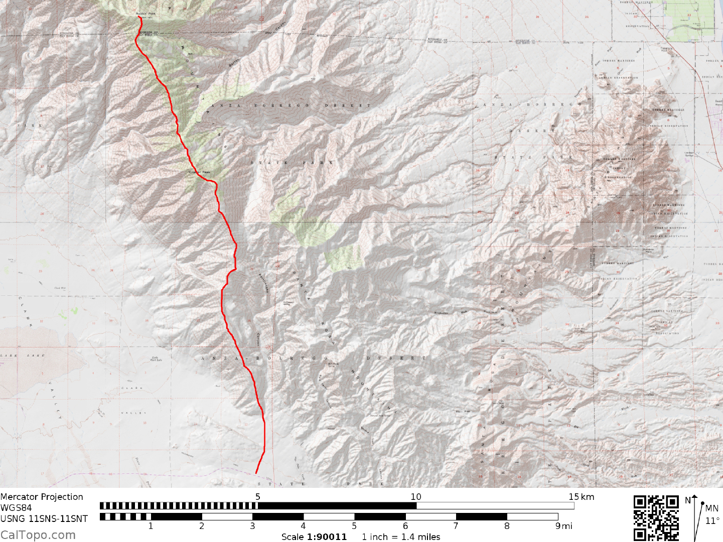
3. Rabbit Peak is also on the list of the Hundred Peaks Section (HPS) of the Sierra Club. Nearby Villager
Peak, located 3.5 miles SE of Rabbit along the crest of the Santa Rosas is also an HPS peak. From Rabbit it's
about a 3 hour climb (one way) over a roller coaster ridge with 1000 feet of net gain to Villager. The return to
Rabbit has a net gain of about 1800 feet.
4. Rabbit can also be climbed from the Anza-Borrego side by starting at the parking spot for Rosa Point (see
Guide No. 4.3). Although this route is not shown on the included maps, following are the hiking directions
for interested parties. From the parking spot hike N about 1.0 mile across the desert flats to the base of the
prominent ridge just left (W) of Rattlesnake Canyon. Hike the ridge N for about 5.0 miles, climbing over a
number of false summits and staying to the right (E) side of point 5640+ en route to Villager Peak. From the
top of Villager follow the ridge line NNW to Rabbit. This route is more strenuous than either Routes A, B or
C described above and is best done as an overnight backpack. Once again, be prepared with the extra water
you'll need for this long trip.
5. If none of the above routes are hard enough for you, then you might want to consider a ridge run along the
crest of the Santa Rosas starting from road's end (locked gate) near Toro Peak. This very strenuous line up
Rabbit is, at minimum, an overnight backpack. The route along the ridge is not obvious in places and will
require routefinding skills, so be prepared with a map and compass and be sure to have enough food, water
and other necessities along to safely do this trip. One way to do this hike is by arranging a car shuttle between
Toro Peak and a selected point in Anza-Borrego Desert State Park. Having done this, you can proceed by
backpacking along the ridge to a point W of Rabbit the first night. Hike over Rabbit on the second day and
follow Route B or C down to Clark Lake (see Drive/Routes B and C directions to Clark Lake) if your vehicles
are there. As an option on the descent you can continue SSE from Rabbit along the ridge to Villager Peak,
then down around the E side of point 5640+,
RABBIT PEAK (CONTINUED)
4 RIVERSIDE COUNTY RANGES GUIDE NO. 4.2
continuing to follow the ridge generally S from here to the desert flats just W of Rattlesnake Canyon. From
here it's a 1.0 mile hike S to County Highway S22 and the vehicles if you chose to leave them there. The
place you would leave vehicles along County Highway S22 is actually the parking spot for Rosa Point. See
Guide 4.3 for driving instructions to this point.