4 RIVERSIDE COUNTY RANGES GUIDE NO. 4.1
MARTINEZ MOUNTAIN 6560+ FEET CLASS 2
MILEAGE: 147 miles of paved road, 0.2 miles of good dirt, 0.9 miles of 4WD road
DRIVE: From Banning, CA. drive 30.3 miles E on Interstate 10 to the Bob Hope Drive exit. Follow Bob
Hope
Drive S for about 5 miles to its junction with State Highway 111 in the town of Rancho Mirage. Turn
left (SE) on State Highway 111 and drive 1.6 miles to State Highway 74, where you'll turn right (S) and drive
15.8 miles to the signed turnoff for the Pinyon Flats Campground. Turn left (S) on paved road 7S06 directly
across the highway from the campground entrance. Two signs at this turnoff will say "Riverside County
Disposal Site" and "Elks Mountain Resort". Drive 0.3 miles to a dirt road, turn left and go about 300 yards to
a large parking area. 2WD's should park here. 4WD vehicles can go another 0.9 miles to the Dolomite Mine
by continuing as follows: From the 2WD parking spot take the road to the right of the one signed BPOE 1643
for 0.15 miles to an intersection. Turn right and drive 0.2 miles to a fork. Take the left branch at this fork
(signed "Cactus Spring") and follow the road as it drops steeply in 0.5 miles to a fork near the Dolomite Mine.
Park. NOTE: Instead of driving in, you might want to consider parking your vehicle along the wide shoulder
of State Highway 74 just E of the Pinyon Flat Campground turnoff (near the Sugarloaf Cafe). Vandalism to
cars parked near the Dolomite Mine has been reported on occasion.
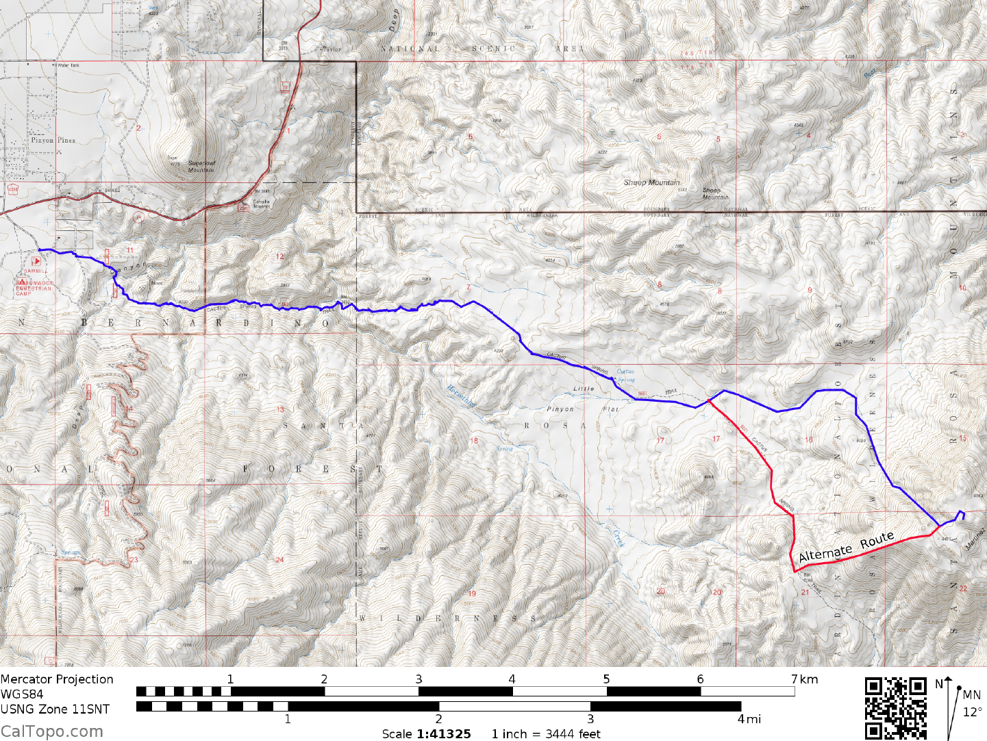
CLIMB: Whether you're starting from the highway or the 2WD parking spot described above, y
ou'll have to
hike to the start of the Cactus Spring Trail located adjacent to the Dolomite Mine. On foot, simply follow the
above 4WD directions to that point. Bearing right at the road fork by the mine, follow it E as it changes from
road to trail. The good trail will descend into Horsethief Canyon, reaching a creek in the bottom of the canyon
in about 2 miles. Running water and cottonwood trees here make for a pleasant rest stop. The trail now
climbs steeply up the opposite bank for about 300 feet of elevation gain, eventually merging into a wash
where it becomes a little hard to follow. Keep a sharp eye out for ducks here and continue hiking in an
easterly direction. In about 2 miles you will come to Cactus Spring, a small seep about 25 yards N of the trail
that is choked with brush and grasses. Don't plan on finding much water here; the spring is less than
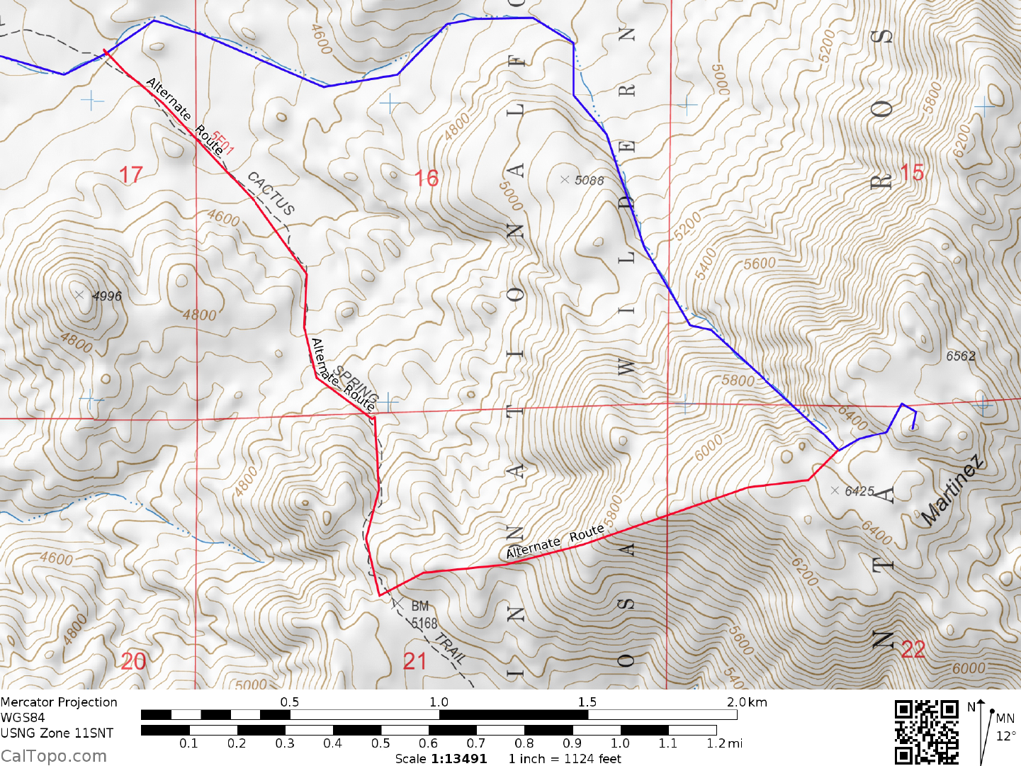
impressive when it comes to water output. Continue E on the trail for about 0.6 miles to a point due N of the
prominent hill 4996. A pinyon pine in the wash with a portion of its trunk growing horizontally will be seen
just before reaching this point. (The trail will start to head SE here, leaving the wash you've been hiking in and
heading for a saddle at 5200 feet about 1 mile WSW of the summit. This is an alternate way to climb
Martinez. Its only drawback is that its very brushy from the saddle to the summit.). Leave the trail here and
hike E in the wash for about 1.5 miles as it eventually turns S around the E side of point 5088. Continue SE
from here up the gully and/or ridge on its left to the summit plateau between points 6425 and 6562. The
highpoint is a prominent pinnacle 0.15 miles E of here at UTM 608127. The pinnacle is easiest to ascend
from the SE side and is rated easy Class 3.
ROUND TRIP STATS/2WD PARKING SPOT: 3700 feet elevation gain, 18 miles, 12 hours
SIDELINES
MARTINEZ MOUNTAIN (CONTINUED)
4 RIVERSIDE COUNTY RANGES GUIDE NO. 4.1
1. Besides being a peak on the DPS List, Martinez Mountain is also on the HPS (Hundred Peaks Section)
Peaks List. A close neighbor of Martinez, Sheep Mountain is also an HPS peak. If you have the desire to do
Sheep, follow the above directions for Martinez to Cactus Spring, leave the trail there and head NNE for
about 1.5 miles to the summit, en route passing over point 5067. Including this side trip in your plans will add
3 miles, 1000 feet of elevation gain and about 2 hours to the round trip stats for Martinez.
2. For overnight car camping in the area you might want to consider the Forest Service campground just off
State Highway
74 at Piny
on Flats. This campground (4000 feet elevation) is just N of the turnoff for the
Cactus Springs trailhead and is a convenient spot from which to get an early start for Martinez. There are 18
tent and RV sites with tables, fire rings, drinking water and chemical toilets available. This is a fee
campground and is open from October through May on a first come-first served basis.
3. With advance planning of a car shuttle, you can do an interesting backpack trip of Martinez Mountain. By
starting out at the Dolom
ite Mine and hiking the Cactus Springs trail as described above, y
ou can climb the
peak, return to the trail and continue following it to Agua Alta spring the same day. The next day you can
hike out to State Highway 86 at Valerie Jean's Date Shop. In addition to the Martinez Mtn 7.5 minute topo
you'll need the Clark Lake NE and Valerie 7.5 minute topos to navigate this route. John Robinson describes
this route in detail in his book San Bernardino Mountain Trails, Trip No. 98. The driving distance between
trailheads is about 38 miles.
Revised 2/6/18