3 SAN BERNARDINO COUNTY RANGES GUIDE NO. 3.16
WHIPPLE MOUNTAIN 4130 FEET CLASS 1
MILEAGE: 253 miles of paved road, 4.2 miles of excellent dirt, 1.0 mile of poor dirt road
DRIVE/ROUTE A: From Vidal Junction, CA. drive 13.8 miles E on State Highway 62, turning left
(N) on an excellent dirt road. This dirt road is just a few feet W of highway milepost 140. Drive N
on this well graded dirt road, en route passing under power lines in 1.5 miles and reaching the
Colorado River Aqueduct in 4.2 miles from the highway. From the aqueduct continue NW on a fair
to poor dirt road (shown on the Parker, Ariz-Calif 7.5 minute topo, 1975 issue as a jeep trail) 1.0 mile
to the boundary of the Whipple Mountains Wilderness Area. Park.
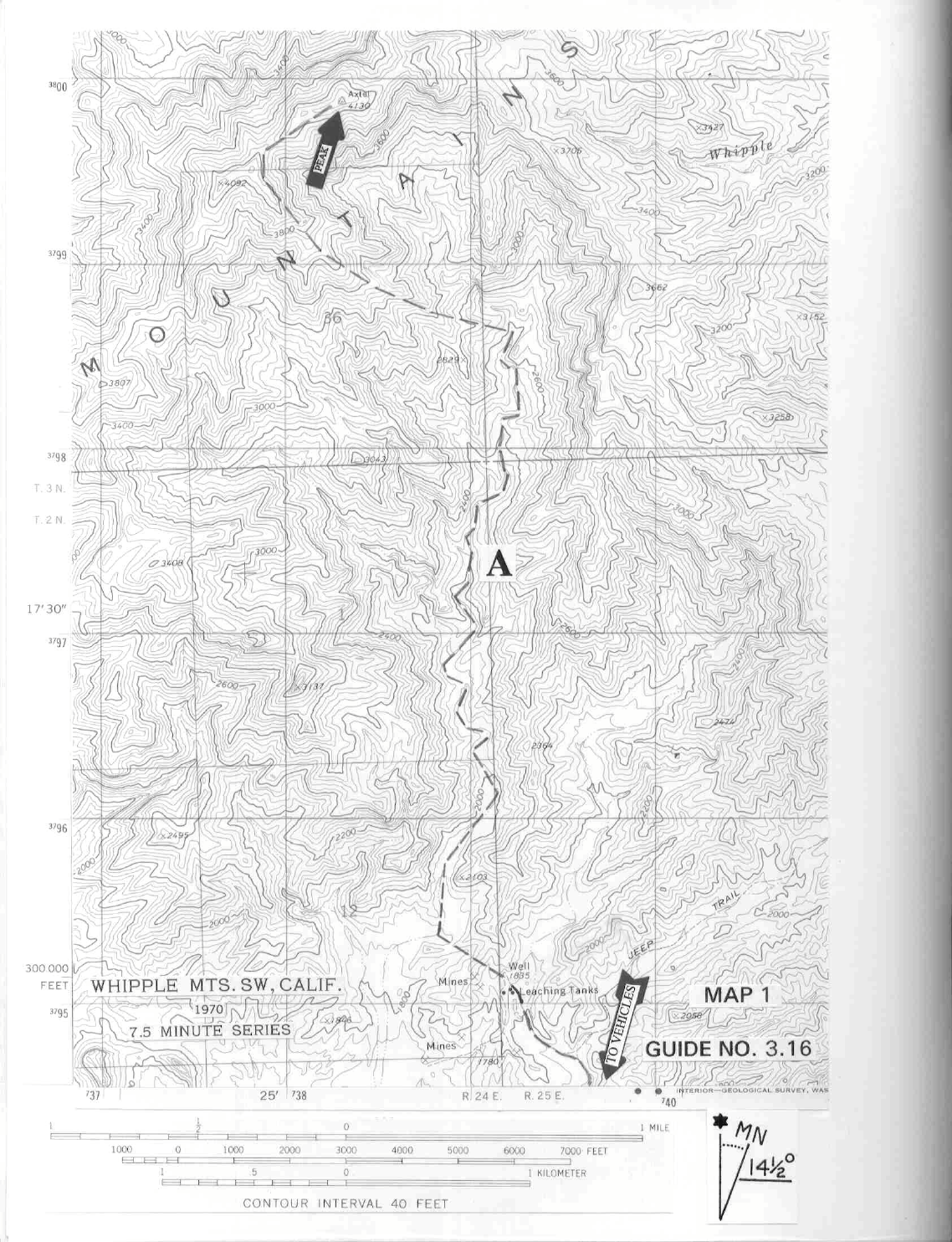
CLIMB/ROUTE A: See Map 1. Hike 0.8 miles NW up the dirt road to a fork. Bear left and continue 1.9
miles to a fork, bearing left again and hiking 1.5 miles to a mine site with five rectangular, concrete leaching
tanks on a hill to the left. The last 3.4 miles to the leaching tanks are hiked in a wash in which you will
generally stay along its western margin. Following the road NW beyond the leaching tanks for 0.25 miles to a
saddle, drop into a large wash to the west. Hike N up this wash approximately 2.5 miles, bearing right at all
major forks until just past a rock outcropping (elev. 2680+) on the right side of the wash at UTM 394986.
Turn left (W) up the ridge, following it to just E of point 4092. Here, contour around the right (E) side of the
ridge, dropping to a saddle approximately 0.3 miles SW of the peak, then up the ridge to the top. See Map 1
for details of this hike from the leaching tanks to the peak.
ROUND TRIP STATS/ROUTE A: 3200 feet elevation gain, 17.5 miles, 12 hours
DRIVE/ROUTES B & C: From Vidal Junction, CA. drive 27.8 miles N on US 95 to the signed, paved
Havasu Lake Road (If coming from Interstate 40, drive 21 miles S of Needles, CA. on US 95). Turn right (E)
on the Havasu Lake Road and drive 9.7 miles to an excellent dirt road which parallels the power lines.
Turning right (SE) at this point, follow the dirt road for 6.8 miles to its junction with a fair dirt road heading
SSW. Turn right here, drive 3.9 miles to a road fork and bear left. In 0.4 miles you'll come to fork which can
be taken either left or right; both forks join back up in a short distance. Drive 1.5 miles beyond this fork to the
War Eagle No. 1 Mine. Park. 2WD's can make it to the mine.
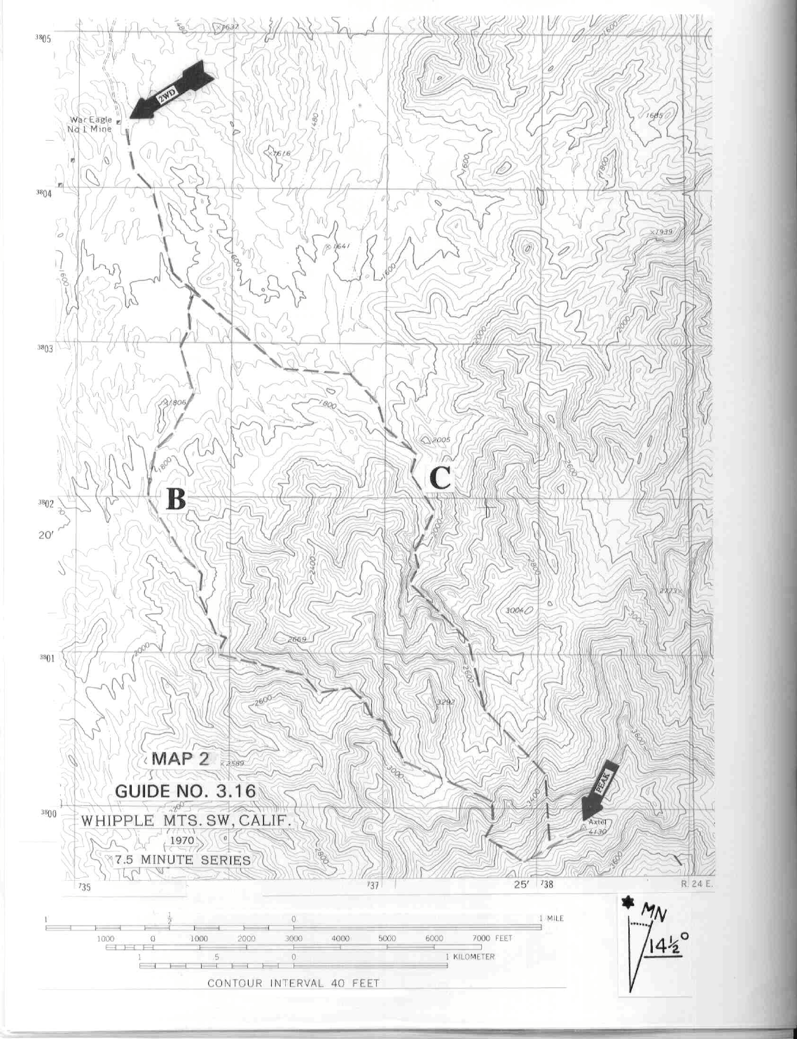
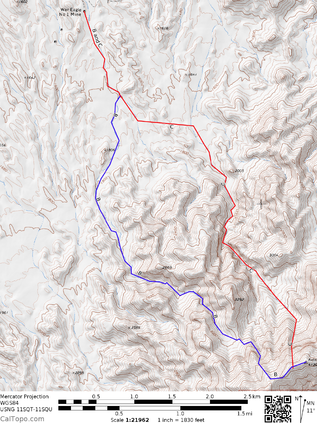
CLIMB/ROUTE B: See Map 2. Hike generally S up the wash that passes just E of point 1806, following it
as it curves SE to the 3000 foot elevation saddle (UTM 374002) 0.3 miles S of point
3292. Work left from here into a gully which can be taken to a saddle on the E-W summit ridge about 0.3
miles SW of the peak. Turn left, walking the ridge to the top.
CLIMB/ROUTE C: See Map 2. From the mine hike 0.75 miles SSE in the wash to a fork. Bear left here and
walk 1.5 miles to the wash just W of point 2005. Hike this wash about 1.0 mile to the 2400 foot elevation
level. Bearing slightly to the right here, gain a ridge which is followed to the E-W summit ridge. Turn left and
walk 0.15 miles to the top.
ROUND TRIP STATS/ROUTES B & C: 2700 feet elevation gain, 9 miles, 6 hours
SIDELINES
WHIPPLE MOUNTAIN (CONTINUED)
3 SAN BERNARDINO COUNTY RANGES GUIDE NO. 3.16
1. Whipple Mountain was named in 1858 for Army Lieutenant Amiel Weeks Whipple, a member of the US
Army Mexican Boundary Commission and Pacific Railroad Survey. Actually, only one of the prominent
peaks in the range was named for him, but in 1903 the US Geological Survey named the entire range in honor
of Whipple. Whipple, a Brigadier General under the command of Joseph Hooker, General of the Union
Army, was killed along with 17,000 other union soldiers in the 1863 Civil War battle at Chancellorsville,
Virginia.
2. Whipple Mountain is located within the boundaries of the Whipple Mountains Wilderness. This new
wilderness area was created as part of the California Desert Protection Act of 1994, Public Law 103-433,
Section 102 (69). The Whipple Mountains Wilderness Area encompasses approximately 77,520 acres of land
and is managed by the Bureau of Land Management (BLM).