3 SAN BERNARDINO COUNTY RANGES GUIDE NO. 3.12
STEPLADDER MOUNTAIN 2927 FEET CLASS 2
MILEAGE: 265 miles of paved road, 10 miles of excellent dirt, 8.2 miles of poor dirt
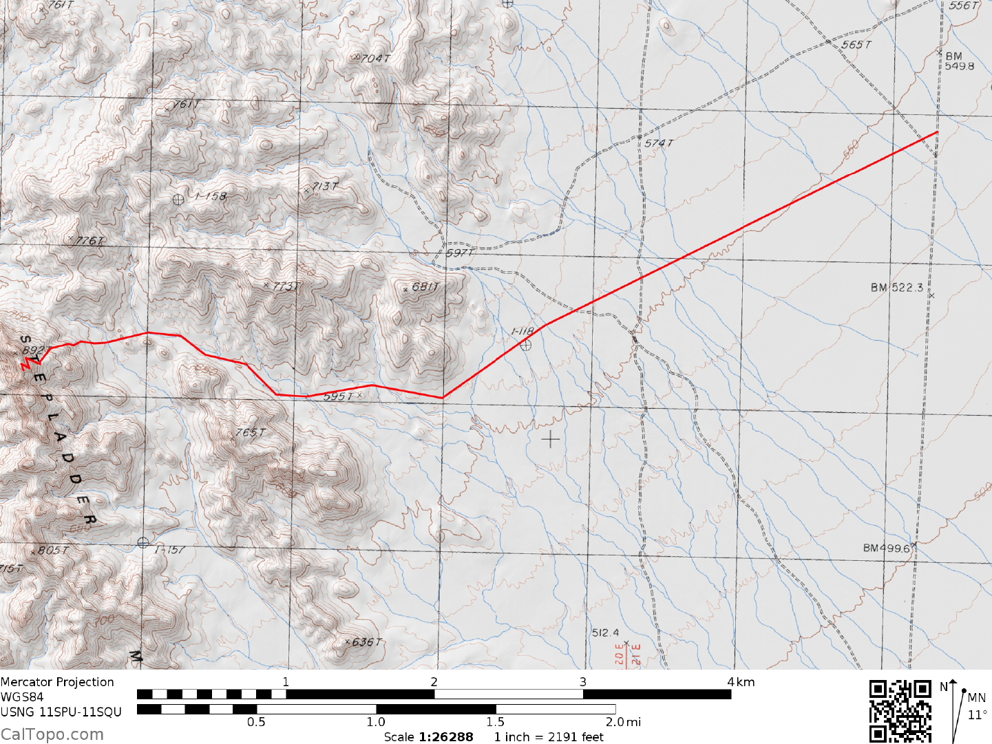
DRIVE: From Vidal Junction, CA. drive 35.9 miles N on US 95 (or 12 miles S on US 95 from
Interstate 40 at
Needles, CA) to its junction with a pipeline road. Be prepared to possibly encounter some deep sand at the
start of this road; a 4WD vehicle may be required. Head W on the pipeline road, driving 7.8 miles to its
junction with an MWD (Metropolitan Water District) powerline and access road. Continue W another 0.55
miles past this junction to a faint dirt road heading left (S) down the Chemehuevi Valley. Turning left here,
follow this poor and sometimes sandy road as it turns right just behind a man made berm, goes about 150 feet,
and then turns S again. Drive about 4.7 miles to the Stepladder Mountains Wilderness boundary. Park.
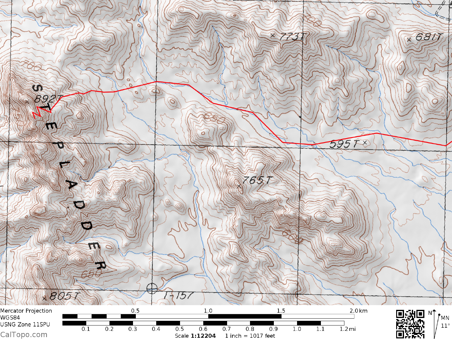
CLIMB: Hike 2 miles due S on the road, turning right and striking off across the desert, reaching the m
outh
of a wash near point 595 at UTM 974290 in about 3 m
iles. Follow this wash WNW about 0.75 miles, leaving
it to continue WNW over some small hills to a saddle 0.3 miles NE of the peak. From this saddle, climb the
obvious chute to the base of cliffs and a prominent cleft that heads up to the notch between the two summit
masses. Ascend the cleft until you can exit left on an easy ledge leading out onto the NE face of the mountain.
A series of zig-zag ledges will bring you to the above-mentioned notch between the two summit masses.
From here climb up easy rock to the southern summit block and register. The rock on Stepladder is loose, so
be sure to carefully test your hand and footholds before putting full weight on them.
ROUND TRIP STATS: 1450 feet of elevation gain, 12 miles, 7-8 hours
SIDELINES
1. The 1985 Stepladder Mountains, Calif. 7.5 minute m
e
tric provisional topo map appears to show the
highpoint of the Stepladder Mountains as the northernmost of three pinnacles on the ridge line. The old 1956
Stepladder Mts., Calif. 15 minute topo is somewhat ambiguous about the highpoint, showing two pinnacles
instead of three in this area, both having identical elevation contour lines. As stated above, the DPS register is
located on the southern of the two summit masses.
2. Stepladder Mountain is located within the boundaries of the Stepladder Mountains Wilderness Area. This
new
wilderness
area was created as part of the California Desert Protection Act of 1994, Public Law 103-433,
Section 102 (64). The Stepladder Mountains Wilderness Area encompasses approximately 81,600 acres of
land and is managed by the Bureau of Land Management (BLM).
Revised 2/6/18