3 SAN BERNARDINO COUNTY RANGES GUIDE NO. 3.11
SHEEPHOLE MOUNTAIN 4593+ FEET CLASS 2
MILEAGE: 173 miles of paved road, 0.25 miles of good dirt road
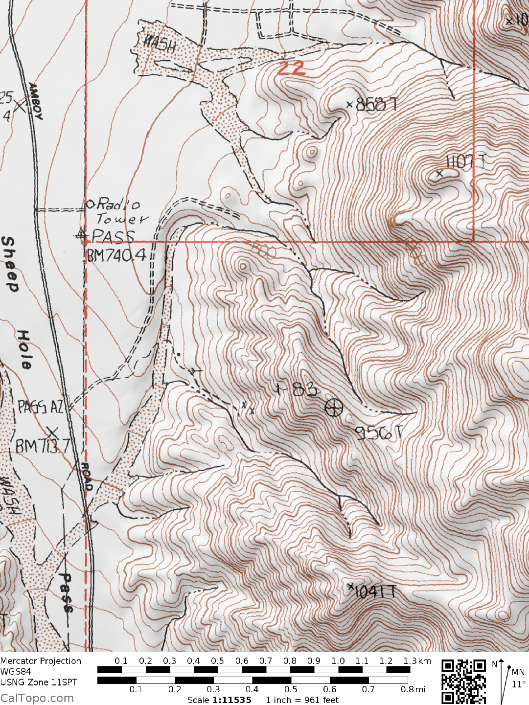
DRIVE/ROUTE A: From the stop light intersection of State Highway 62 and Adobe Road in Twentynine
Palms, CA drive 2.0 miles N on Adobe Road to the
signed Amboy Road. Turn right (E), following the road
for 25 miles to Sheephole Pass. There is a microwave relay station dirt road turnoff on the right (E) side of the
road at the pass. 0.55 miles before or S of the station turnoff, turn right (E) on a
obscure, sandy 4WD dirt
road. Drive 0.1
m
iles to an intersection and continue straight for another 0.15 m
iles to a large, flat parking
area adjacent
to
a major N-S sand wash. If you're in the right location there will be two mine adits and a
concrete foundation across the wash from you. Park.
Note: The microwave relay station, which is located on a good dirt road about 0.2 miles just east of Sheephole
Pass, is a good place to park and start the climb from if you do not have a 4 wheel drive vehicle. See the map
below.
CLIMB/ROUTE A: Drop 30 feet into the wash and turn right, hiking S for about 150 yards to an obvious
wash heading E into the m
ountains. Turn left (E) here, following this rocky wash for about 1.0 mile to its end
E of point 1041. Hike E up the ridge from here to the flats below the summit ridge. From here you'll have to
pick your way through huge talus to reach the summit cap, a sloping rock that is easiest climbed on its S side.
ROUND TRIP STATS/ROUTE A: 2300 feet elevation gain, 4.5 miles, 5-7 hours, possibly longer.
DRIVE/ROUTE B: Follow DRIVE/ROUTE A directions to the m
icrowave relay station dirt
road turnoff on
Sheephole Pass. Turn right (E) here, drive 0.1 m
iles to a fork and bear right. Follow the poor dirt road that
curves N along the backside of the microwave station for 0.15 miles to its intersection with a poor dirt road
heading right (E). Turn right, following this road for 0.6 miles to its end at the base of the mountain, en route
passing a concrete "water collector" on the right side of the road. As with the A route, 4WD is recommended. See
note above.
CLIMB/ROUTE B: From
the parking spot identify the prominent pinnacle on the skyline ridge at a 104°
bearing and its neighboring peaklet 15° further to the
right. Start by climbing the rocky gully to the saddle
between these two landmarks. At the saddle turn right (S) and hike 0.3 miles to a rock peaklet which is
bypassed low around its left (N) side to avoid steep slabs higher up. Beyond this obstacle head SE across easy
flats to the summit area, where you'll join up with ROUTE A for the climb to the top.
ROUND TRIP STATS/ROUTE B: 2100 feet elevation gain, 4.5 miles, 5-7 hours, possibly longer.
SIDELINES
1. The Sheephole Mountains are located within the boundaries of the Sheephole Valley
Wilderness Area.
This new wilderness area was created as part of the California Desert Protection Act of 1994, Public Law 103-
433, Section
102 (61). The Sheephole Valley Wilderness Area encom
passes approximately 174,800 acres of
land and is managed by the Bureau of Land Management (BLM).
Revised 11/2/17
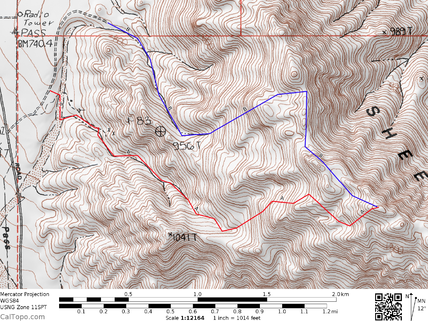
Alternate parking
A parking and start
B Parking and start