3 SAN BERNARDINO COUNTY RANGES GUIDE NO. 3.10
OLD WOMAN MOUNTAIN 5325 FEET CLASS 2
MILEAGE: 305 miles of paved road, 1.7 miles of good dirt, 3.5 miles of sandy road. (For route A, see below for
C and D)
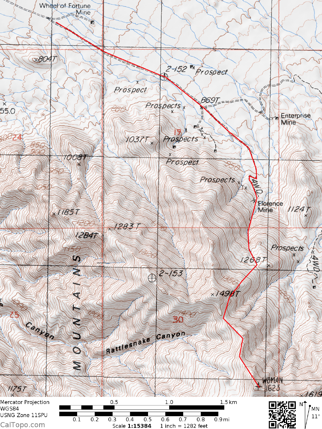
DRIVE/ROUTES A & B: From Barstow, CA. drive 52 miles E on I-40 to the town of Ludlow. Exit the
freeway here, drive through town and continue E on the National Trails Highway (Old Highway 66) for 53
miles to the signed, dirt Danby Road. For those approaching from the east, the Danby Road is located
approximately 9.3 miles W of Essex, CA. Turn right (SE) on the Danby Road and go 1.7 miles, crossing the
RR tracks and passing through Danby. Continue SE on a sandy road approximately
5.5 miles to the Old
Wom
an Wilderness boundary just past a gas pipeline right-of-way. Park.
CLIMB/ROUTE A: Hike SE up the road
about 2.0 miles to the abandoned Florence Mine at the base of the
Old Wom
a
n Mountains. From the mine head S up a gully to the saddle just W of point 1268.
Contour S to a
wash which is followed up to the ridge just SE of point 1498. From here head SSE for approximately 0.5
miles along the ridge to the summit.
CLIMB/ROUTE B: From the mine head SE up a gully for about 0.5 miles to a wash. Turn right (SW) and
hike
0.2 miles up the wash to
a fork. Bearing right, continue SW for 0.5 miles to a ridge, where you'll join up
with Route A. Head SSE along the ridge for about 0.5 miles to the summit.
ROUND TRIP STATS/ROUTES A & B: 3200 feet elevation gain, 7 miles, 6-7 hours
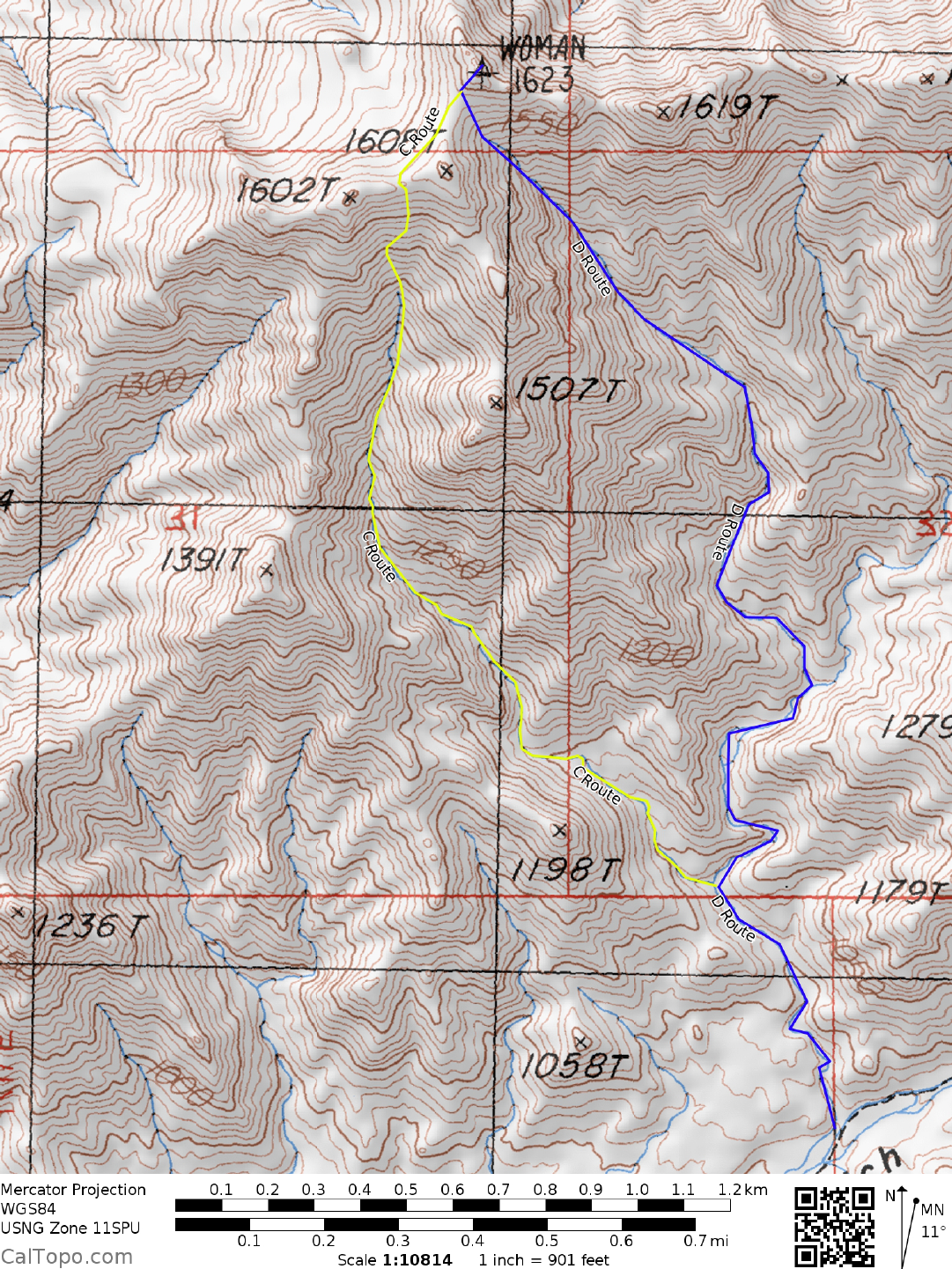
DRIVE/ROUTES C & D: Following the driving directions
for ROUTE A to Ludlow, drive E on the National
Trails Highway (Old Highway 66) for 40 miles to the sm
all town of Chambless, located approximately 12
miles E of Amboy, CA. Turn right (SE) on the signed, paved Cadiz Road and go 4.4 miles to where it
crosses the RR tracks. Less than 50 yards S of the tracks (pavement ends here) turn left on a good dirt road
which parallels the tracks. Drive 5.5 miles to a fair dirt road and turn right. Drive 1.9 miles to a 4-way
junction and turn left. Go 2.3 miles to within 100 yards of a pipeline pumping station and turn right on a fair
dirt road heading S over Skeleton Pass (The last 0.7 miles of road to the pumping station is actually a dirt
runway for small planes servicing the station.). In 1.5 miles turn left (E) on a fair dirt road heading towards
the Old Woman Mountains. Follow this road for 5.0 miles to where it drops into a wash at the mouth of
Carbonate Gulch. Bear left at a fork in 0.6 miles and go another 1.6 miles to a very narrow, high-walled wash
on the left. Park here. 4WD and high clearance is needed to get to this point because of a few sandy stretches
and rocky areas encountered along the way. Climbers with only 2WD vehicles should probably not bother
with this route but instead opt for Route A or B.
CLIMB/ROUTE C: Hike NW up the high-walled wash, coming to a major fork in 0.5 miles. Bear left,
hiking through an obvious narrow
slot which opens into a large wash that is followed to the saddle between
points 1602 and 1608. Contour around the left (W) side of point 1608 to the saddle just S of the summit, then
up 100 feet to the top. This route is rated Class 2.
ROUND TRIP STATS/ROUTE C: 2200 feet elevation gain, 4 m
iles, 4 hours
3 SAN BERNARDINO COUNTY RANGES GUIDE NO. 3.10
OLD WOMAN MOUNTAINS (CONTINUED)
CLIMB/ROUTE D: Hike NW up the high-walled wash, coming to a major fork in 0.5 miles. Bear right,
hiking up the wash for 0.5 miles to a fork at 1105 meters (3625 feet) elevation (UTM 627256). Bear left
(NNW) here and go 0.5 miles to where the wash narrows with a high wall on your right. Just beyond this
point climb a dry waterfall and continue up to where the wash broadens and turns NW, heading for the saddle
on the ridge between point 1608 and the summit. At the saddle, turn right and climb 100 feet to the peak.
This route is rated Class 2 except for the dry waterfall, which is 10 feet of easy Class 3.
ROUND TRIP STATS/ROUTE D: 2200 feet elevation gain, 5 miles, 4 hours
SIDELINES
1. Because gasoline stations are few and far between in this portion of the Mojave Desert, it's best to start
this
trip with a full tank of gas in Barstow. Gas is available at certain hours in Ludlow, Am
boy and Chambless,
but you just might not find these stations open when you are in need of a fill-up. So play it safe and get that
full tank in Barstow.
2. The Old Woman Mountains got their name from the prominent peak located approximately 5.5 air miles
SE of the sum
mit. Viewed from the E side, this
craggy peak, said to resemble a woman with a shawl draped
over her head is named Old Woman Statue. A climb of the statue can be done from either the Scanlon Gulch
road on the west side of the range or the Painted Rock road on the east side, both of these roads being “cherry-
stemmed” access corridors into the Old Woman Wilderness Area. The Scanlon Gulch route can be done as
follows: DRIVE: Follow the Old Woman Mountain DRIVE/ROUTES C & D instructions to the Carbonate
Gulch road turnoff 1.5 miles S of the gas pipeline pumping station. Instead of turning left here, continue
straight (SE) 2.3 miles to the Scanlon Gulch road. Turn left (E) and drive 7.5 miles to a fork at the boundary
of the Old Woman Wilderness Area. Park. As a check on your location, a windmill can be seen several
hundred yards up the left fork. CLIMB: Hike up the right fork road about 1.7 miles to the end of the wash at
the base of the mountain. Keeping right of the large rock gully heading up from the wash, ascend a steep
boulder slope to the ridge line about 400 feet above. Turn right (SE), following the ridge around the N
side of point 1441, then E to a saddle 0.2 miles N of point 1469. From this saddle head NE through
boulders and slabs past point 1479, traversing below the W face of Old Woman Statue to the ridge line
saddle just N of the peak. Climb class 2-3 rocks just below the W side of the saddle to a notch on the W
face of the Statue located at the foot of a near-vertical 35 foot high crack. Climb the crack (rated 5.7 or
5.8), topping out on a wide ledge along the southern base of the summit block. This portion of the climb
can be protected with a number of small to medium sized chocks and/or camming devices placed in the
main crack and also a narrow flake crack a few feet to the left. A large boulder on the wide ledge above
the crack serves as a very good belay and rappel anchor. From the ledge reach up 7-8 feet to the first in a
series of a dozen bolted hangers that lead up the exposed, 40 foot high vertical S face of the summit block
to the top. Bring plenty of climbing gear to reach the top! RT STATS: 7 miles, 2400 feet elevation gain,
8-10 hours
OLD WOMAN MOUNTAINS (CONTINUED)
3 SAN BERNARDINO COUNTY RANGES GUIDE NO. 3.10
3. Carbonate Gulch, the starting point for southern routes on the mountain, has some very nice places for
overnight camping. One excellent, wind protected campsite is in the narrow, high-walled canyon at the
parking spot for Routes C and D. Many other spots can be found that offer quiet and solitude in this not-often
visited canyon.
4. A trip to the sand dunes bordering the eastern margin of Cadiz Dry Lake is a nice adjunct to a climb of Old
Wom
an Mountain. From the RR crossing at the end of the paved
Cadiz Road (see Drive/Routes C & D
above) continue SE on an excellent dirt road which parallels the RR tracks for about 9 miles. This road
crosses over the tracks at one point and runs along the western side of the tracks as you approach the dunes.
Turn right (SW) on a dirt road heading towards the dunes and drive about 2.5 miles to road's end near the start
of the sand.
5. The desert around Old Woman Mountain is a botanical transition zone between the plant species of the
Mojave
and Colorado Deserts. Because of its north-south orientation and the wide, low profile of the Cadiz
Valley which runs along the W side of the Old Wom
an range, plant species have used it as a migratory
highway between these two distinct deserts. The area has thus become home to a rich variety of plants.
6. Old Woman Mountain is located within the boundaries of the Old Woman Mountains Wilderness Area.
This new wilderness area was created as part of the California Desert Protection Act of 1994, Public Law
103-433, Section 102 (43). The Old Woman Mountains Wilderness Area encompasses approximately
146,020 acres of land and is m
anaged by the Bureau of Land Manageme
nt (BLM).
Revised 2/5/18