3 SAN BERNARDINO COUNTY RANGES GUIDE NO. 3.9
EAST ORD MOUNTAIN 6168 FEET CLASS 1
MILEAGE: 134 miles of paved road, 7.1 miles of excellent dirt, 2.1 miles of fair dirt road, 0.4 miles of 4WD
road
DRIVE/SOUTHERN APPROACH: From Interstate 15 S of Victorville, CA. drive approxim
ately 23 miles E
on State Highway 18 (or E on the Bear Valley Cutoff Road from Interstate
15 about 12 miles to the State
Highway 18 junction, then E on State Highway 18 about 11 miles) to Lucerne Valley, CA. From the stop sign
at the junction of Highways 18 and 247 in Lucerne Valley, drive E on State Highway 247 (Old Woman
Springs Road) 5 miles to the paved, signed Camp Rock Road. Turn left (N) and drive 4.0 miles to a fork.
Bear right and go 2.4 miles to where the pavement ends, continuing on an excellent dirt road for approximately 7
miles to a set of power lines Turn left on this fair dirt road ((BLM Road 6657), crossing under
power lines and a sandy wash for about one mile to road 6659. Turn right and follow this poor dirt road to another
fork. Go left to the ruins of a corrugated metal water tank
on your right. 2WD vehicles park here. 4WD's
can continue another 0.4 miles as follows: At a fork in 0.1 miles, bear left on the rocky, lower road for 0.15
miles to a second fork. Keep right and go 0.15 miles up a steep, rocky road to a wide spot where the road begins
curving to the left. Park. See Northern Approach for directions to the Grandview Mine for route B.
DRIVE/NORTHERN APPROACH: Leave Interstate 40 at the Daggett exit (6 to 7 m
iles E of Barstow) and
drive S about 100 feet to the paved, signed Pendelton Road. Turn left
(E) and go 1.1 miles to where the
paveme
nt ends, continuing now on the signed, excellent Camp Rock dirt road as it curves right (S) and heads
uphill, away from the Interstate. About 9 miles from the end of pavement, bear left at a fork and go 8.4 miles
to a 4-way junction. Turn right (S) and drive
approximately 5+ miles. There will be a sign for Johnson Valley
OHV area, and shortly after, pass under power lines and you will meet
up with a poor dirt road that heads W
(see map below). (NOTE: roads showing on the topo, including the one leading into the TH have been closed
at Camp Rock Road). BLM Road 6657 leads across a sandy wash and in about a mile will intersect with a
connecting road 6659, which will take you to the Standard
Route TH. Otherwise, continue to the end to the
Grandview Mine, and take route B.
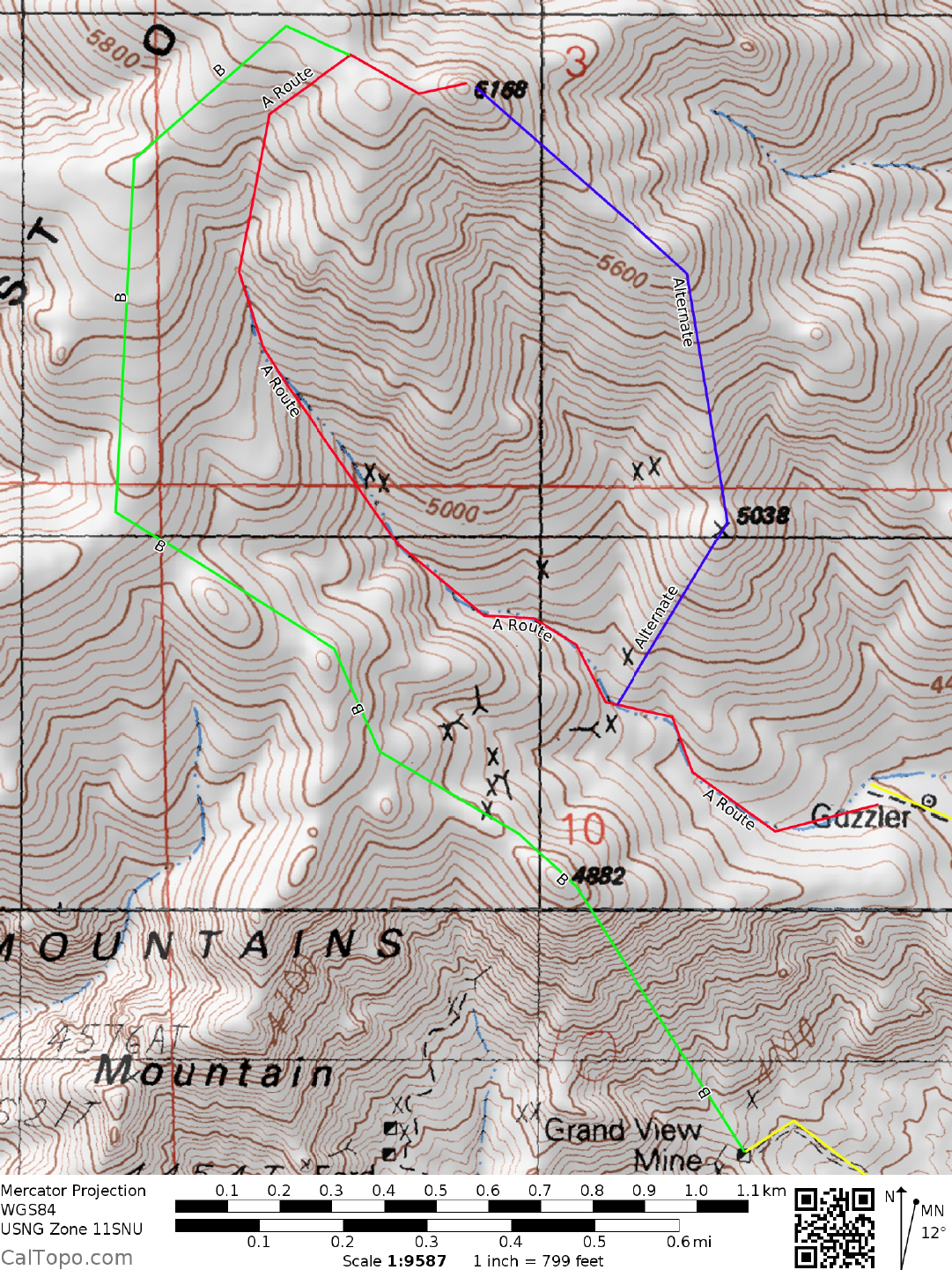
CLIMB: From the 4WD parking spot, the peak lies at a bearing of 345° and is distinguished by the large
brown rock faces directly below the summit and the prominent saddle just to the left (W) of the top. Drop
down 20 feet into the wash just N of the parking spot, hiking W up the wash and bearing right at a major fork
in 0.25 miles. Following this right fork to the prominent saddle just W of the peak, turn right and scramble up
120 feet of second class rock to the summit. An alternate route is as follows: From the major fork 0.25 miles
from the cars, bear right and follow the wash for 200 yards. Leaving the wash here, hike NE to the saddle just
N of point 5038. Follow the ridge N then NW to the top.
ROUND TRIP STATS/4WD: 2000 feet elevation gain, 2 miles, 2.5 hours
ROUND TRIP STATS/2WD: 2200 feet elevation gain, 2.8 miles, 3 hours
Revised 2/27/18
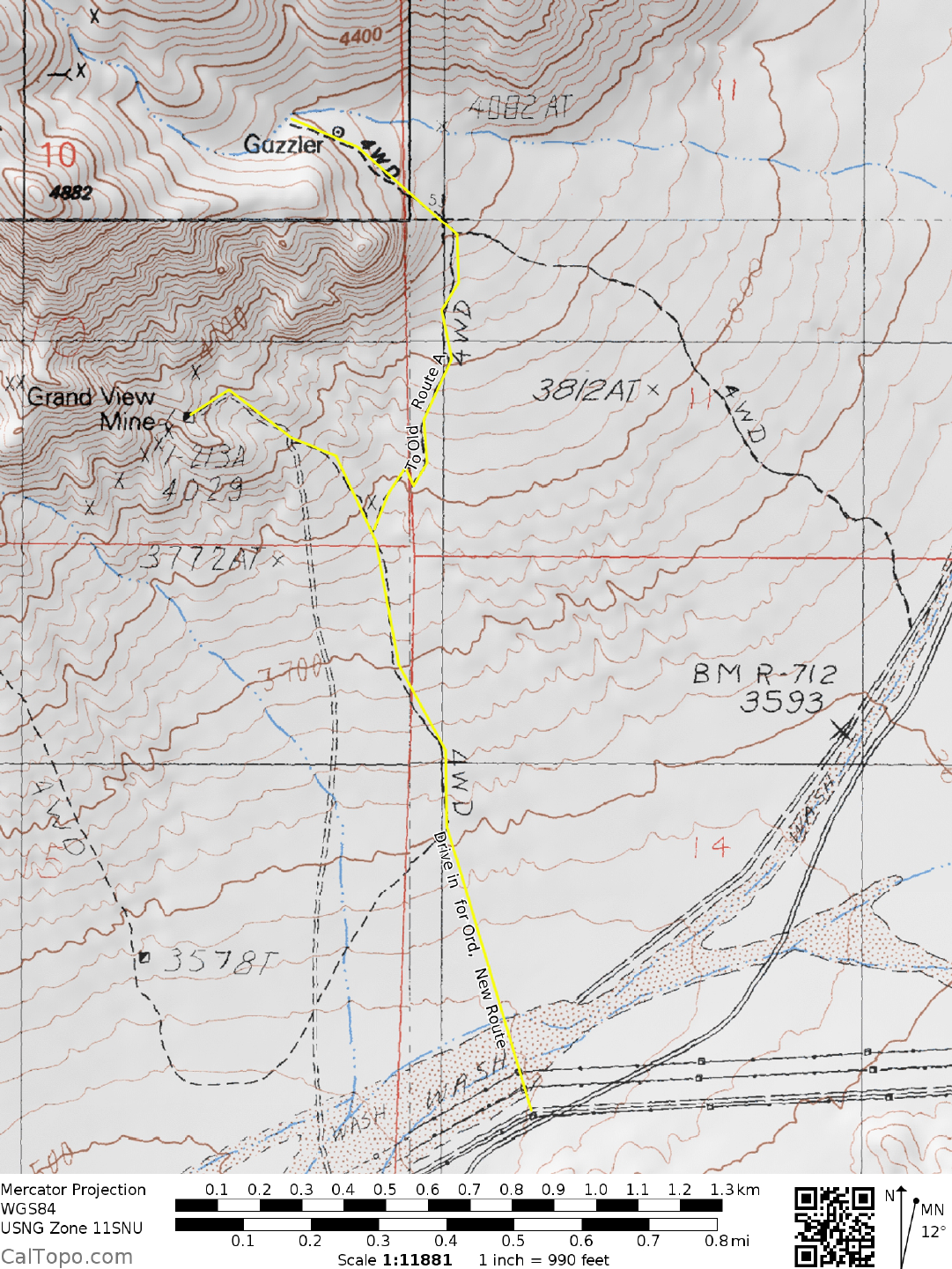
Old route in, now
closed --------------->>>>>
Power lines
Sandy wash
New road to 4WD
route not on topo maps