3 SAN BERNARDINO COUNTY RANGES GUIDE NO. 3.6 & 3.7
MITCHELL POINT 7048 FEET CLASS 2
EDGAR PEAK 7162 FEET CLASS 2
MILEAGE: 316 miles of paved road. Add 8 miles of good dirt road for Mitchell Point.
DRIVE/ROUTE A (EDGAR PEAK): From Barstow, CA drive 100 miles E on Interstate 40 to the Essex
Road exit. Turn left (NW) on the paved Essex Road and drive 15.6 miles to the Providence Mountains
State Recreation Area Visitor Center and Park Headquarters at Mitchell Caverns. Park.
CLIMB/ROUTE A (EDGAR PEAK): At the N end of the Visitor Center parking lot, you'll find the Mary
Beal Nature Trail. Follow it NW about 0.5 miles to its end, then continue generally W up the main canyon.
At a fork in the canyon at about the 1800 meter (5900 foot) level, bear right and ascend to a saddle 0.3 miles
S of the peak at 2020 meters (6630 feet) elevation. Turn right (N) and follow the rocky summit ridge to the
top, bypassing a few Class 3 false summits en route.
ROUND TRIP STATS/ROUTE A (EDGAR PEAK): 2900 feet elevation gain, 5 miles, 7 hours
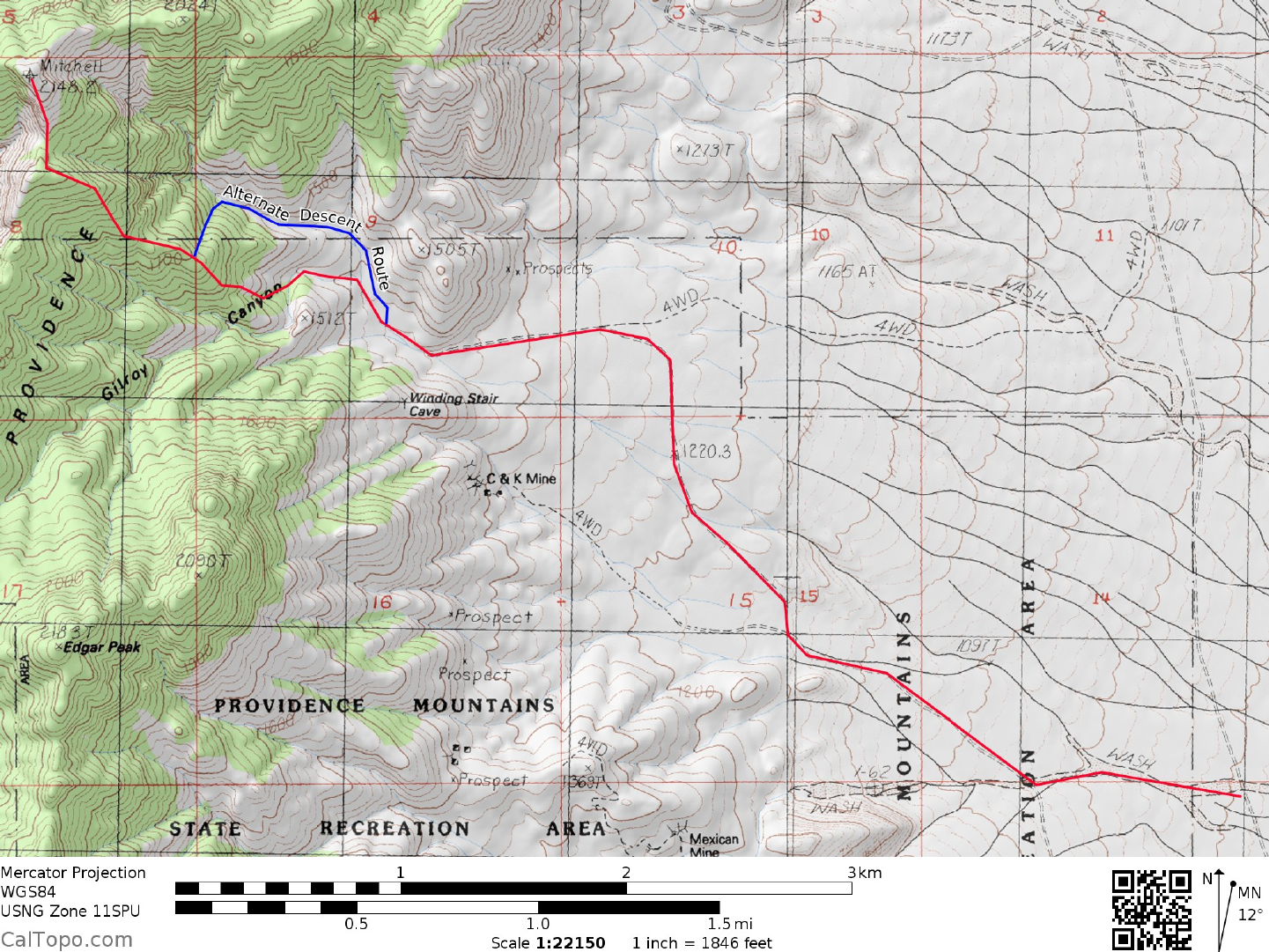
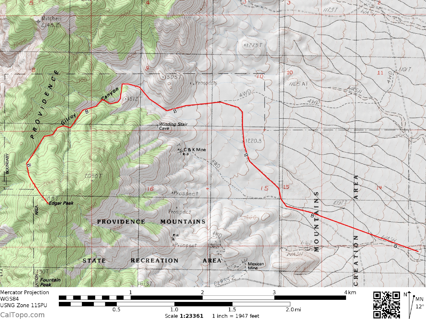
DRIVE/ROUTE B (EDGAR PEAK): From Barstow, CA drive 100 miles E on Interstate 40 to the Essex
Road exit. Turn left (NW) on the paved Essex Road and drive 13.6 miles to a cattle guard across the
pavement at the signed entrance to the Providence Mountains State Recreation Area (This point is 2.0 miles
before the end of the road at the Park Headquarters and Visitor Center). 0.3 miles beyond or W of the cattle
guard turn right on a poor dirt road (high clearance recommended as a minimum) and follow it 2.4 miles to
a T-junction. Turn left here and drive 0.5 miles to the end of the road at a large parking area. This parking
spot is also the start of ROUTE C on Mitchell Point and is the best place to park if you're planning on doing
both peaks in a single dayhike by traversing the ridge between the two summits (See SIDELINES 1 below).
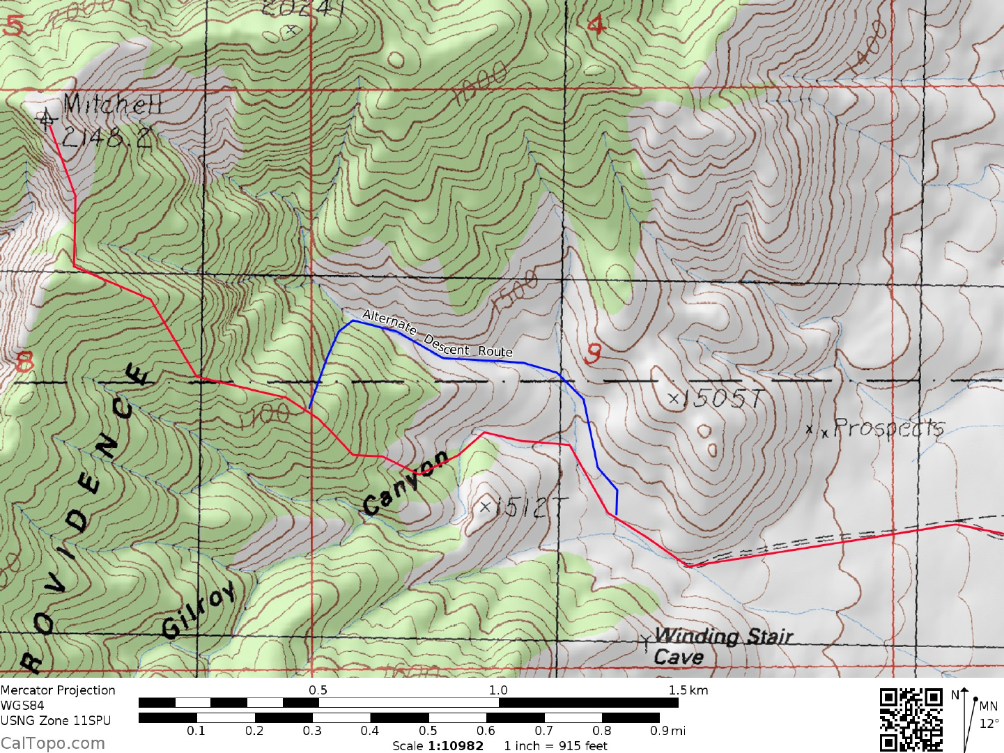
CLIMB/ROUTE B (EDGAR PEAK): Hike NW up the canyon for 0.3 miles to a fork. Bear left (W)
following the wash around the N and W sides of point 1512 to a fork at 1500 meters (4920 feet) elevation.
Bear left and hike 0.2 miles, gaining 200 feet of elevation to another fork, where you'll bear left again.
Follow this branch generally SW for 0.4 miles, leaving the canyon here and hiking due S for 0.6 miles to
the peak. ROUND TRIP STATS/ROUTE B (EDGAR PEAK): 2800 feet elevation gain, 5 miles, 7 hours
DRIVE/ROUTE C (MITCHELL POINT): Follow DRIVE/ROUTE B (EDGAR PEAK) directions to the
start of the climb.
CLIMB/ROUTE C (MITCHELL POINT): Hike NW up the canyon for 0.3 miles to a fork. Leave the wash
here and head W up the ridge to about 1700 meters (5580 feet) elevation. Head NW at this point, gaining
the skyline ridge at a saddle about 0.2 miles S of the peak. Climb N to the summit.

3 SAN BERNARDINO COUNTY RANGES GUIDE NO. 3.6 & 3.7
MITCHELL POINT/EDGAR PEAK (CONTINUED)
ROUND TRIP STATS/ROUTE C (MITCHELL POINT): 3000 feet elevation gain, 5 miles, 7 hours
Legal access to the routes above are still closed and it is uncertain when they may be open again. Be advised
that attempting climbs of Edgar and Mitchell by other routes than the Mitchell D route are considered
trespassing by the state park.
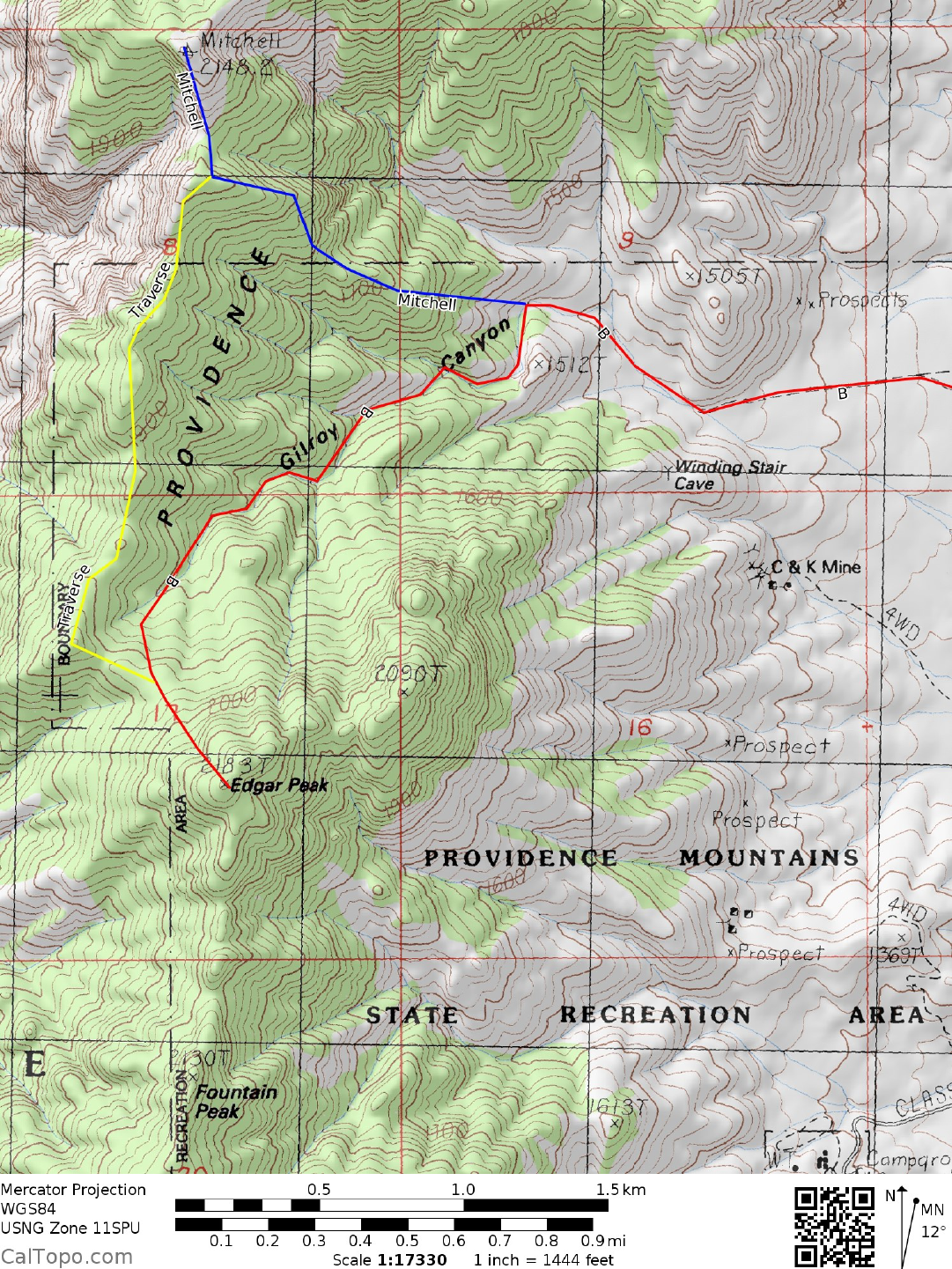
DRIVE/ROUTE D (MITCHELL POINT): From the Essex Road exit off Interstate 40, drive NW 10.6 miles
on the paved Essex Road to a signed fork "Blair Bros. 7IL Ranch" (This fork is 0.9 miles beyond the Essex
Road/Black Canyon Road junction.). Bear right on this good dirt road and drive 4.9 miles to a fork at an 8
foot high metal pole. Bear left (the right fork is signed "Private Road" and goes to the Blair Brothers Ranch)
and drive 0.75 miles of good dirt to a fork. Bear right and drive 2.3 miles of good dirt to the remains of the
Bonanza King Mine; a dilapidated stamp mill and some galvanized metal tanks strewn along the hillside.
Park. NOTE: The Bonanza King Mine is once again an active claim, so don't go poking around it or plan
on camping there overnight. The Blair brothers may not be too understanding of trespassers. There is a
way to avoid driving up to the mine but still reach Route D. Back at the fork 0.75 miles beyond the 8 foot
high metal pole, bear left instead of right on a 4WD dirt road and drive 1.2 miles W to the ruins of old stone
cabins just S of the mine site. Park.
CLIMB/ROUTE D (MITCHELL POINT): From the mine site, hike S up the steep road, over a saddle to
an area of stone cabin ruins. From here hike SW for about 0.4 miles along the base of the mountain, then
right (W) up a slope to gain the ridgeline running W toward the summit. Follow the ridge to point 2024,
located about 0.5 miles ENE of the peak. As you approach the peak from here, contour well below the
sharp ridgeline on its left (S) side, regaining the ridge before reaching the summit. Follow easy slopes from
here to the top. This route involves traversing some severe terrain on loose and sharp rock. Consider
bringing sturdy gloves, wearing long pants, and having lots of patience!
ROUND TRIP STATS/ROUTE D (MITCHELL POINT): 3200 feet elevation gain, 4.5 miles, 7-8 hours
SIDELINES
1. Both peaks can be done together in one long day from the mouth of Gilroy Canyon via a
combination of Routes B and C. Access to the trailhead for these routes is via a locked gate which is
controlled by the State Park Ranger at the Mitchell Caverns Vistior Center. At one time in the past very
strict regulations were in effect regarding access, however it appears that the level of regulation has varied
over time. You can obtain the current status of this controlled area by writing the Providence Mountains
State Recreation Area, P.O. Box 1, Essex, CA 92332-0001, or calling the Sector Office at 760-928-2586
3 SAN BERNARDINO COUNTY RANGES GUIDE NO. 3.6 & 3.7
2. The Providence Mountains State Recreation Area encompasses 5,900 acres of prime desert
including theMitchell Caverns Natural Preserve. Animals found here include bighorn sheep, bobcats,
coyotes, ringtail cats, badgers and a host of smaller species.
MITCHELL POINT/EDGAR PEAK (CONTINUED)
3. One of the main draws of the area is the Mitchell Caverns, a series of limestone caves formed
roughlybetween 12 and 250 million years ago by a combination of earth movement and surface water
percolation. Two caverns, the Tecopa and El Pakiva are open to public tour and are equipped with stairs,
railings and special lighting to facilitate their viewing. The tour of the cave takes between 1 and 1½ hours
and involves a 1½ mile walk. The cave is lighted so no flashlights are necessary. Cameras and video
cameras are OK, but no flash photography or other light sources are allowed. For tour information times
and pricing write the Providence Mountains State Recreation Area, P.O. Box 1, Essex, CA 92332-0001,
or call the Sector Office at (805) 954-0662.
4. Six campsites with picnic tables and fire rings are available on a first-come, first-serve basis at the
Park Headquarters. The sites are each limited to 8 people and 2 vehicles and there is a fee associated with
their use.
5. Mitchell Point was named in honor of Jack Mitchell, a Los Angeles resident whose hobby of
prospecting brought him to the Providence Mountains in 1929. During the 1930's he developed the area
around the caverns by building a road to them and erecting several stone houses which now serve as Park
Headquarters. In 1954, Jack and his wife Ida sold 97 acres of land to the State of California for development
of this State Recreation Area.
6. The current maps are based on trips taken in the past five years. The park has re-opened and as
soon as atrip report comes back, I'll update the maps.
Revised 11/7/17