3 SAN BERNARDINO COUNTY RANGES GUIDE NO. 3.4
NEW YORK MOUNTAIN 7532 FEET CLASS 3
MILEAGE: 255 miles of paved road, 6 miles excellent dirt, 2.4 miles good dirt, 0.4 miles poor dirt.
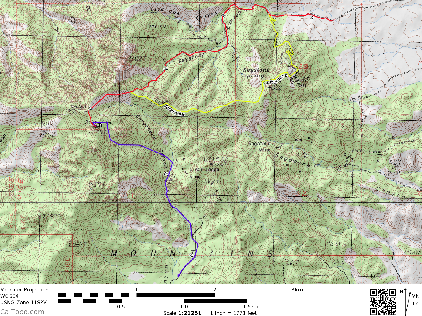
DRIVE/ROUTE A (KEYSTONE CANYON)/NORTHERN APPROACH: From Baker, CA drive 40 miles
N on Interstate 15 to the Nipton Road exit. Turning right at the off-ramp stop sign, drive 3.4 miles
E on
Nipton Road to the signed Ivanpah Road. Turn right (S) on the paved Ivanpah Road and follow it 9.5 miles to
the Union Pacific railroad tracks. Just over the tracks follow the paved road as it turns left and then bears right
for 2.4 miles to the end of pavement. Continue 6.0 miles S on excellent dirt to a good dirt road turnoff on the
right (W). This turnoff is 1.2 miles beyond or S of the signed Hart Mine Road. Turning right, bear left at a
fork in 75 yards and continue 0.6 miles SW to a fork. Bear right, continuing 1.8 miles W to a fork where
standard clearance 2WD's should park. 2WD high clearance and 4WD vehicles can bear left then quickly
right and continue up the canyon approximately 0.4 miles to the NPS Wilderness area boundary.
DRIVE/ROUTE A (KEYSTONE CANYON)/SOUTHERN APPROACH: Follow the driving instructions
for
Route B/Southern Approach to the New York Mountain Road. Instead of turning left here, continue 6.3
miles N on the Ivanpah Road to the dirt road turnoff W for Key
stone Canyon. Follow Route A/Northern
Approach driving instructions from here to the start of the hike.
CLIMB/ROUTE A (KEYSTONE CANYON): From the 2WD high clearance/4WD parking spot at the NPS
Wilderness area boundary
, hike 0.3 miles up the
road to a fork. Bearing left, hike 0.1 miles to a fork. Bear
right and hike approximately 0.6 miles to roads end at a mine site. From the mine climb SW up steep and
loose slopes or along the ridge to the right of these slopes to a saddle at 2060 meters (6760 feet) elevation at
UTM 542033. From this saddle you'll see the peak at a bearing of 228° across Caruthers Canyon. Contour
SW without dropping elevation until you reach the dry streambed of Caruthers Canyon, then up the opposite
side directly to the saddle just N of the peak. From here hike around the N side of the summit block to reach
its W side, where you'll boulder and bushwhack to a right slanting Class 3 crack near the summit. Climb the
crack to its top, dropping into a small "bowl" and then up a short but awkward crack to the final summit rocks.
A rope should be carried for climbers uncertain of themselves on steep rock.
An alternate route can be found by taking a left at the mouth of the canyon and following a steep, switchbacking
road to a mine site. Gain the ridge above and contour left to a saddle on an east/west trending ridge and follow it
to the saddle above the mine site mentioned in the A directions. Continue on the A route to the summit.
ROUND TRIP STATS/4WD/ROUTE A: 2000 feet elevation gain, 4.2 miles, 4 hours
ROUND TRIP STATS/2WD/ROUTE A: 2100 feet elevation gain, 5 m
iles, 5 hours
DRIVE/ROUTE B (CARUTHERS CANYON)/NORTHERN APPROACH: From Baker, CA drive 40 m
iles
N on Interstate 15 to the Nipton Road exit. Turning right at the off-ramp stop sign, drive 3.4 miles
E on
Nipton Road to the signed Ivanpah Road. Turn right (S) on the paved Ivanpah Road and follow it 9.5 miles to
the Union Pacific railroad tracks. Just over the tracks follow the paved road as it turns left and then bears right
for 2.4 miles to the end of pavement. Continue S 12.3 miles on excellent dirt to the signed junction with the
New York Mountain Road. This junction is just N of a large water tank on the
NEW YORK MOUNTAIN (CONTINUED)
3 SAN BERNARDINO COUNTY RANGES GUIDE NO. 3.4
W side of Ivanpah Road. Turning right (W) here, follow the New York Mountain Road 5.6 miles to its
intersection with a good dirt road heading N into Caruthers Canyon. Turn right (N) and drive 0.6 miles to a
water tank on your left. Continue straight (N) another 0.4 miles to a fork and bear right. Drive 0.1 miles to a
second fork and bear right again, continuing 0.7 miles to where the road worsens. All vehicles should park in
this vicinity. Although 4WD's can get another 0.25 miles or so, the road gets very bad further up the canyon
and turnaround spots are hard to find. Good car camping sites can be found along the road in Caruthers
Canyon.
DRIVE/ROUTE B (CARUTHERS CANYON)/SOUTHERN APPROACH: From Interstate 40 at Mountain
Springs
Sum
mit (28 miles W of Needles, CA or 65 miles E of Ludlow, CA) drive N on the signed, paved
Mountain Springs Road to the town of Goffs. Turn left on the Goffs Road and drive 0.2 miles to where you'll
make a right on the signed, paved Lanfair Road. Drive N about 10 miles to where the pavement ends, then
continue another 10.8 miles on excellent dirt to the signed New York Mountain Road. Follow Drive/Route
B/Northern Approach instructions from this intersection to the start of the hike. Note that on the AAA San
Bernardino County Map the Lanfair Road is called the Ivanpah Road once it strikes N of Cedar Canyon Road.
CLIMB/ROUTE B (CARUTHERS CANYON): From the 2WD parking spot, continue hiking N up the dirt
road for about 0.75 m
ile to its end at 1850 m
eters (6070 feet) elevation near an abandoned mine site. From
here ascend a gully at a 295° bearing, keeping New York's prominent neighbor, a pinnacle located 0.2 miles E
of the summit on your right as you climb. Passing the prominent pinnacle, you'll clearly see the summit
boulders of New York straight ahead. Climb around the left (S) side of the summit mass to its W side, where
you'll boulder and bushwhack to a right slanting Class 3 crack near the summit. Climb the crack to its top,
dropping into a small "bowl" and then up a short but awkward crack to the final summit rocks. A rope should
probably be carried for climbers uncertain of themselves on steep rock.
ROUND TRIP STATS/4WD/ROUTE B: 1800 feet elevation gain, 3.5 miles, 4 hours
ROUND TRIP STATS/2WD/ROUTE B: 1900 feet elevation gain, 4 miles, 4+ hours
SIDELINES
1. Located in the high desert country of the Mojave National Preserve, there are many good camping
possibilities around New York Mountain. Caruthers Cany
on, at 5500
feet elevation on the S side of the range
offers basically undeveloped campsites amid stands of live oak and Joshua trees. There is at least one site on
the E side of the canyon that has a large table and concrete BBQ pit suitable for groups up to about 10 people.
On the E side of the range, Keystone Canyon has limited camping. As mentioned in the Drive/Route A
instructions above, there are a few good undeveloped sites among the pine trees. Farther afield is Mid Hills,
an established campground at 5600 feet elevation with numerous sites having tables, firepits, chemical toilets
and drinking water. This campground is located about 10 miles SW of
New York Mountain and is easily accessed by excellent dirt roads. See the AAA San Bernardino
County
Map for directions to this cam
pground.
3 SAN BERNARDINO COUNTY RANGES GUIDE NO. 3.4
2. About 15 miles W of New York Mountain is a very unique geologic formation known as Cima Dome. The
dome rises nearly 1500 feet above the surrounding desert floor and covers a land area of approximately 75
square miles. Its nearly perfect symmetry as a dome can be observed from many points in the area,
particularly from the north (Interstate 15) and south (Mid Hills campground). Looking at a topo map of the
dome (Mescal Range 15 minute series) reveals concentric circles with an outer diameter of about 8 miles. The
dome was formed by an uplifting of molten monzonite followed by thousands of years of natural erosion.
Continuing W from Cima Dome you'll find the Cinder Cones National Natural Landmark, a 26,000 acre area
containing 32 volcanic cinder cones. These cones are composed primarily of basalt and some of the older
ones are estimated to be about 10 million years old.
3. New York Mountain is located within a Wilderness Unit of the Mojave National Preserve, formerly the
East Mohave National Scenic Area. This wilderness area was created as part of the California Desert
Protection Act of 1994, Public Law 103-433, Section 106 (a)(3). The Mojave National Preserve encompasses
approximately 1.4 million acres of land, of which 695,000 acres are designated as Wilderness areas. The East
Mojave National Preserve is managed by the National Park Service (NPS).
4. There is a checkerboard of private and public lands around the New York Mountains. Since the passage of
the California Desert Protection Act of 1994 and the creation of the East Mojave National Scenic Area,
some
private property
owners have become more sensitive about trespassing and overnight camping on their lands.
Please respect the rights and wishes of private landholders the same as you would respect the regulations in
effect on NPS and BLM administered lands.
Revised 7/28/17