3 SAN BERNARDINO COUNTY RANGES GUIDE NO. 3.3
CLARK MOUNTAIN 7907 FEET CLASS 3
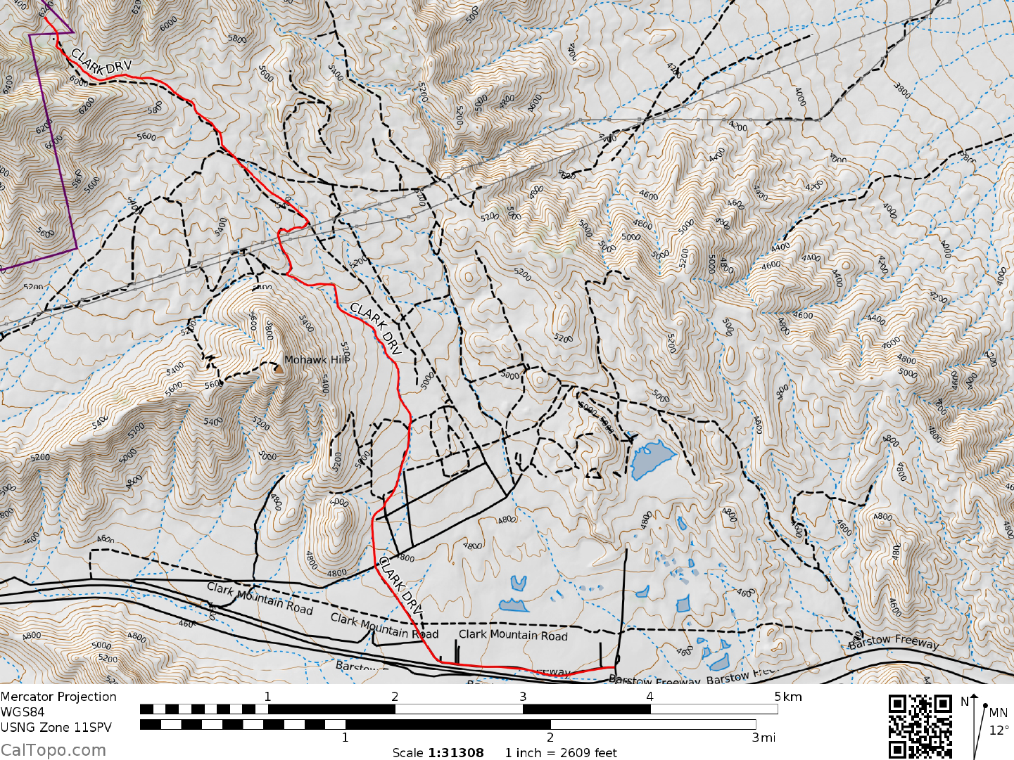
MILEAGE: 236 miles of paved road, 4.7 to miles of good to poor dirt road.
DRIVE: Exit I-15 N at Bailey Road on Mountain Pass. Turn left (N) over the freeway and make a left turn
on the paved Clark Mountain Road. Drive W 1.1
miles until the pavement ends at a cattle guard. Continue W
0.4 miles on excellent dirt to a four-way junction. Turn right (keeping a mine tailings pile on your right) and
go 0.6 miles to a second junction. Turn left here and follow a road paralleling wooden power poles for 1.8
miles to a fork just past an electrical substation. Go left at this fork and at the next fork in 50 yards. In 0.2
miles the road switchbacks left followed by a right switchback in another 0.1 miles. 1.0 mile past this second
switchback bear left at a fork and drive 0.6 miles to the road's end at a picnic grounds with three tables and a
BBQ pit.
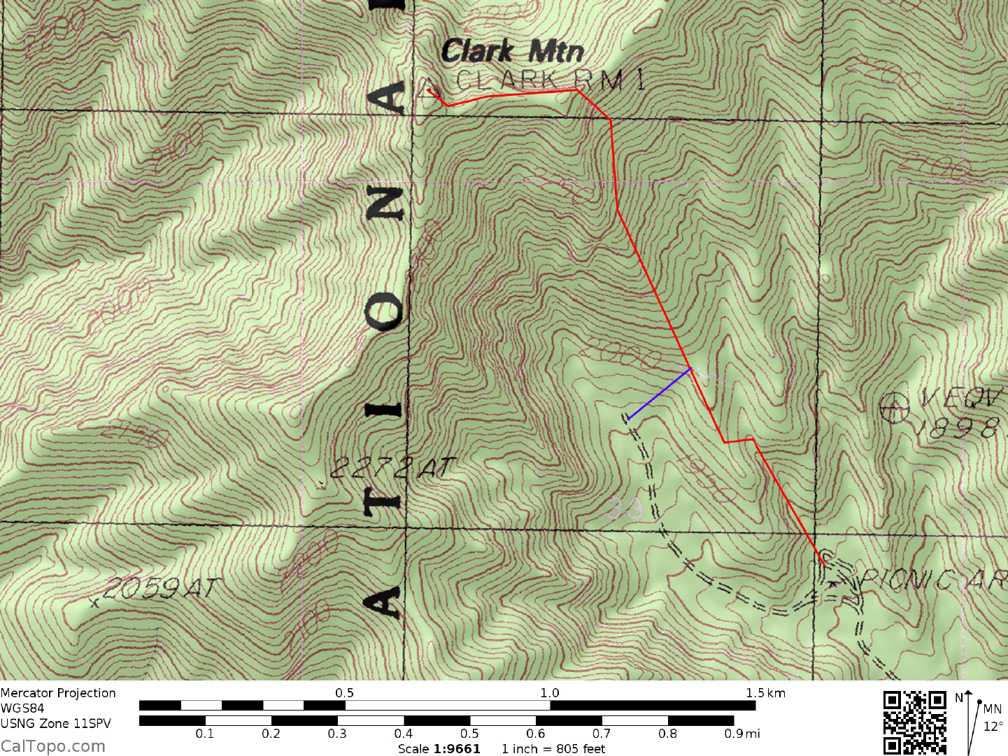
CLIMB: Walk up the small canyon directly behind the picnic grounds a short distance until progress is
blocked by
brush and a dry
waterfall. Exit right on dirt slopes, passing the waterfall and topping out on a
saddle. From the saddle drop down about 100 feet to a large wash heading up towards the peak. Hike up this
wash a short distance until brush becomes a problem, then exit left up slopes heading to the base of cliffs high
on Clark (from the alternate parking spot, reach these slopes by hiking 0.2 miles E). Hike up and along the
base of cliffs nearly all the way to the skyline ridge, then turn left up a steep 20 foot Class 3 pitch (some
climbers may want a rope here). Above this obstacle, head left and up over Class 2-3 terrain to just below the
ridgeline, where easy slopes are hiked W over one false summit to the actual highpoint.
ROUND TRIP STATS: 1900 feet elevation gain, 2 miles, 3 hours
SIDELINES
1. If you'd like to visit a side of Clark Mountain not scarred by heavy mining activity, then plan on exploring
the Pachalka Spring area on the SW side of the
mountain. Highlights of this trip include a visit to an Indian
petrogly
ph site and a look at some well preserved Mexican style arrastras, primitive ore milling devices used
by miners in the mid 1860's. To get there, leave Interstate 15 at the Cima Road exit and drive 6.1 miles N on
paved road to the Pachalka Spring dirt road turnoff. As a check, this dirt road turnoff is 0.5 miles N of a water
tank located just off the right (E) side of the road. Drive the poor dirt road (2WD high clearance
recommended) E for 3.6 miles to a fork. A left here will take you to the arrastras in about 0.2 miles. Bearing
right at the fork, you'll arrive at the Pachalka Spring turnoff in 1.1 miles (year round water makes this place a
favorite haunt of the local bighorn sheep herd). Continuing another 0.15 miles beyond the spring turnoff, park
near the ruins of an old shack and walk a short distance E into the wash. The dark cliffs on the opposite side of
the wash contain numerous petroglyphs.
2. Clark Mountain is located within the Mojave Wilderness of the Mojave National Preserve, form
erly the
East Mojave National Scenic Area. This wilderness
area was created as part of the California Desert
Protection Act of 1994, Public Law 103-433, Section 106 (a)(3). The Mojave National Preserve encompasses
approximately 1.4 million acres of land and is managed by the National Park Service (NPS).
Revised 7/28/17