2 DEATH VALLEY RANGES GUIDE NO. 2.18
BROWN PEAK 4947 FEET CLASS 2
MILEAGE: 264 miles of paved road, 10 miles of good dirt, 6.5 miles of poor dirt road
DRIVE/ROUTE A/SOUTHERN APPROACH: Although the driving approach to ROUTE A is best done
with a 4WD or high-clearance vehicle, a carefully driven 2WD vehicle should be able to get to the start of this
climb. From Shoshone, CA. drive 1.5 miles N on State Route 127 to its junction with State Route 178, where
you'll turn left (W) and drive 5.7 miles to the unsigned Greenwater Valley Road at highway milepost 37.00.
Turn right (NW) here, following the good but washboard-like dirt road up Greenwater Valley for 10.0 miles
to the turnoff for Deadman Pass, marked with a 6 foot high metal pole just off the left (W) side of the road.
En route to this turnoff you'll cross three sandy washes at approximately 3.1, 6.4 and 6.7 miles from State
Highway 178. If you go past the Deadman Pass turnoff by mistake, you will reach an 8 foot high metal pole
on the right (E) side of the Greenwater Valley Road in 0.5 miles (The dirt road heading W at this pole is the
road to Smith Mountain). Simply turn around and backtrack 0.5 miles. Turning right (NE) on the poor dirt
road to Deadman Pass, drive 4.6 miles to the pass, which is marked by a USGS benchmark on a small
concrete pad (benchmark reads 3264' 42LC). Continue N over the pass 1.9 miles to a large, flat parking area
just off the right side of the road at the 3000 foot elevation level. Park.
DRIVE/ROUTE A/EASTERN APPROACH: Drive 19.4 miles N of Shoshone, CA on State Highway 127 to
highway milepost marker 34.50. Turn left here, following a poor dirt road with a few soft spots in it for 1.4
miles to a junction at a wooden post. Turn left (E), driving 0.2 miles to a very sharp turn to the right.
Following the road through this turn, drive 2.0 miles SSW to the signed boundary of Death Valley National
Park. Continue 3.4 miles SE and park, leaving you about 1.9 miles short of Deadman Pass.
DRIVE/ROUTE A/NORTHERN APPROACH: From State Highway 190 at Ryan Junction (18.2 miles W of
Death Valley Junction, CA) turn S on the signed Dante's View Road and drive 7.4 miles to the signed
Greenwater Valley Road. Turn left here and go SE for about 18 miles to the turnoff for Deadmans Pass,
marked by a 6 foot high metal pole just off the right (W) side of the road. Follow the above described
SOUTHERN APPROACH driving directions from here to the start of the climb. NOTE: As you're driving
SE on the Greenwater Valley Road, nearing the 17.5 mile mark and approaching the Deadmans Pass turnoff,
keep an eye out for a white pole on the left (E) side of the road (The dirt road heading W at this white pole is
the road to Smith Mountain). The Deadmans Pass Road turnoff is 0.5 miles past this pole on your left.
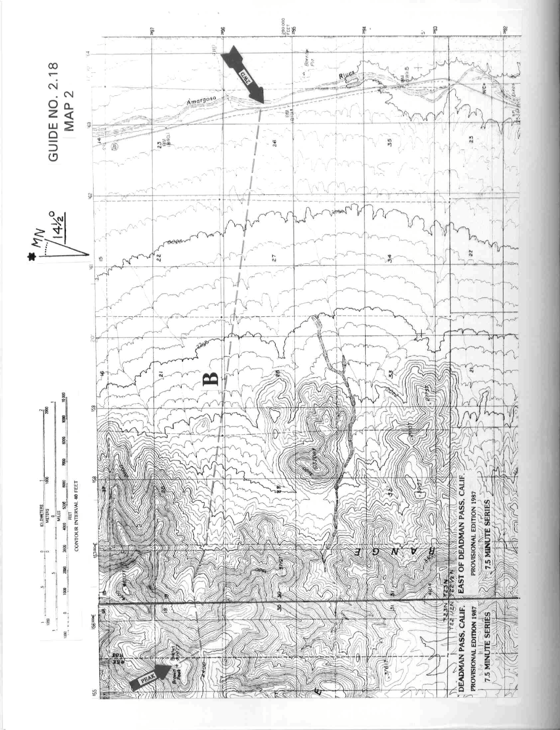
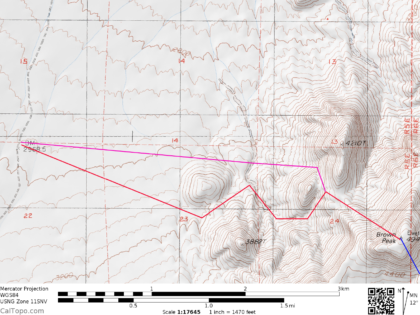
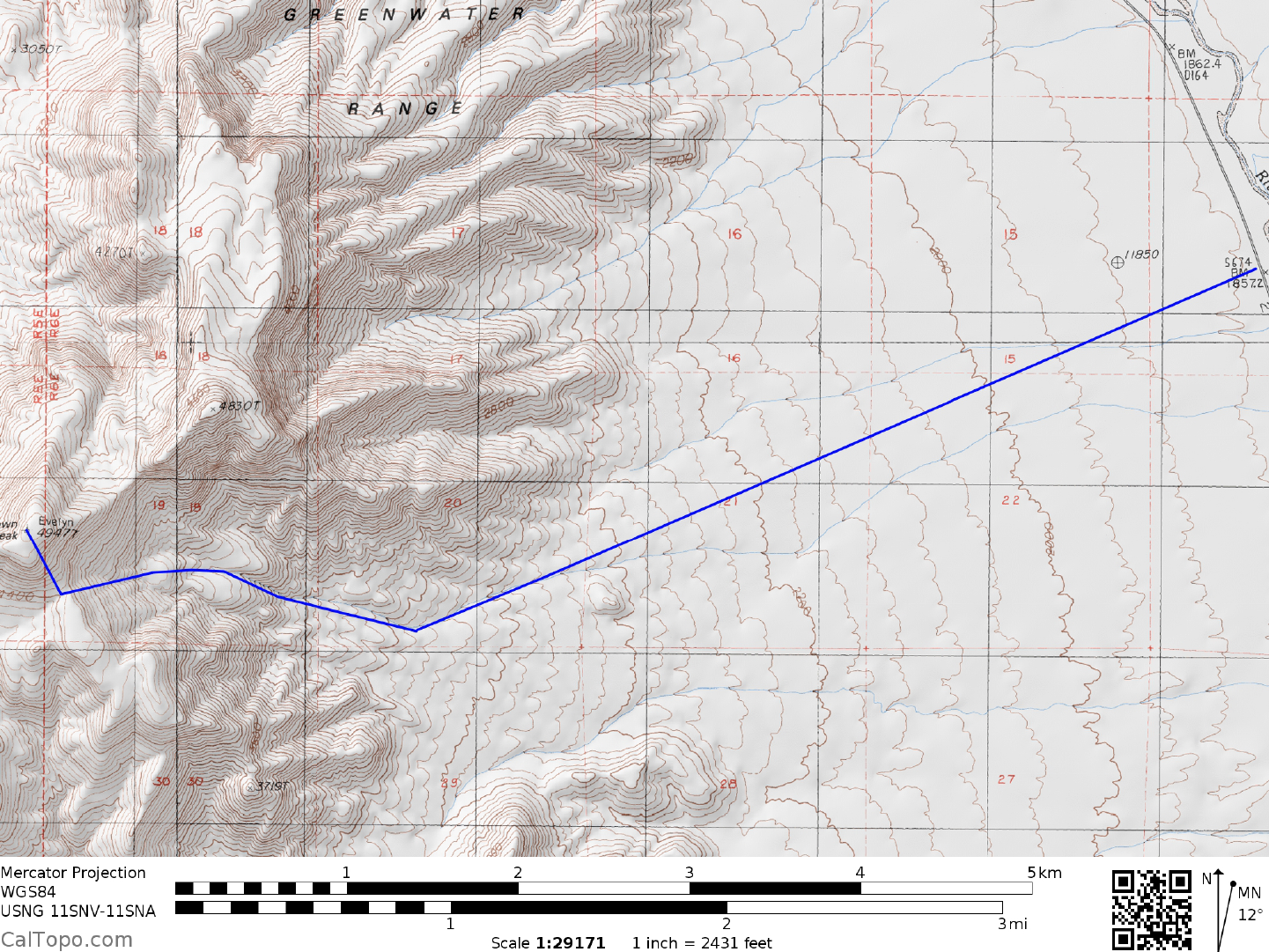
CLIMB/ROUTE A: See Map 1. From the vehicles identify a saddle (UTM 534971) at bearing 100°, located
0.35 miles NW of point 3882. Hike across the desert flats to this saddle. Heading NE, drop down from the
saddle to a wash and then up over a small ridge to a larger wash. Turn right (SE) up this larger wash and in
0.25 miles bear left, following its main branch as it curves E. Hike this branch to near the upper end of the
canyon, where you'll take a left fork (NNE) up to a small saddle E of point 3800+. Head E from this saddle,
climbing to a broad saddle at 3920+ feet elevation (UTM 547972). From here a rib leads SSE to join a use
trail at 4400 feet elevation, just W of the summit. Follow the trail to the top. A slight variation on ROUTE A
may actually prove to be a bit faster on the roundtrip. The variation starts at the same parking spot as
described above and contours around the N side of hill 3320+, crossing
BROWN PEAK (CONTINUED)

2 DEATH VALLEY RANGES GUIDE NO. 2.18
the major N-S running wash and then heading E uphill to the small saddle 0.1 miles E of point 3800+. From
here follow the normal ROUTE A directions to the summit.
ROUND TRIP STATS/ROUTE A: 2000 feet elevation gain, 6.5 miles, 4-5 hours
DRIVE/ROUTE B: Without a 4WD or high-clearance 2WD vehicle, you might want to consider doing
Brown Peak from the east. Although this is a much longer hike than ROUTE A, it does not require driving
any poor dirt roads on the approach. From Shoshone, CA drive N 10.0 miles on State Highway 127, parking
on the dirt shoulder 0.2 miles N of highway milepost 25.00. If your coming S on State Highway 127 from
Death Valley Junction, CA the drive is about 17 miles to this parking spot.
CLIMB/ROUTE B: See Map 2. From the parking spot the peak is at a bearing of 270°. Hike W across the
desert flats at that bearing for about 4 miles to the mouth of a canyon at UTM 570963. Follow a wash up this
canyon to an area of whitish rock where you'll encounter some very easy dry waterfalls. Climb W up these
"falls" to the start of steeper slopes at about 3800 feet elevation. Continuing W, climb these slopes to a saddle
(4400 feet elevation) located 0.3 miles SE of the summit. Turn right (NW) at the saddle and climb to the
summit plateau and register.
ROUND TRIP STATS/ROUTE B: 3200 feet elevation gain, 10 miles, 8 hours
SIDELINES
1. This peak is located within the boundary of Death Valley National Park.
2. Brown Peak was named in honor of Charlie Brown, a longtime resident of Shoshone, CA and environs and
a California State Senator in the 1930's. Brown, in his younger days was the deputy sheriff of Greenwater, a
turn of the century boom town in Greenwater Valley just W of Brown Peak.
3. See Sidelines 1, Stewart Point (Guide No. 2.19) for details on the nearby Tecopa Hot Springs.
4. Overnight camping is allowed at Deadman Pass, however you must stay parked in the large, open area on
the E side of the pass and not have your vehicle in any way situated in an off-road position. For day parking
at the start of Route A or anywhere else along the Deadman Pass road you must park your vehicle parallel to
the road, being sure to keep all four tires on the road.
A
A Variation
B