2 DEATH VALLEY RANGES GUIDE NO. 2.16
SMITH MOUNTAIN 5913 FEET CLASS 1
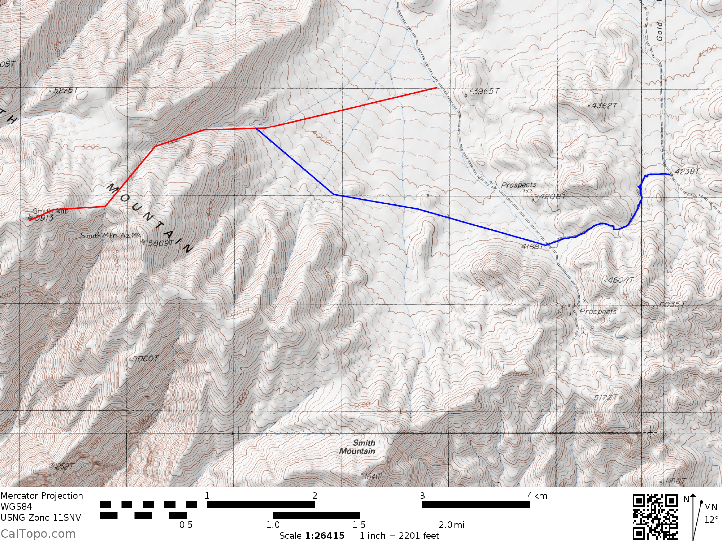
MILEAGE: 264 miles of paved road, 10.5 miles of good dirt, 12.6 miles of fair to poor dirt road.
DRIVE/SOUTHERN APPROACH: From Shoshone, CA. drive N 1.5 miles on State Route 127 to its
junction with State Route 178, where you'll turn left (W) and drive 5.7 miles to the unsigned Greenwater
Valley Road at highway milepost 37.00. Turn right (NW) here, following the good but washboard-like dirt
road up Greenwater Valley for 10.5 miles to the Gold Valley Road junction. This junction is marked with an
8 foot high metal pole on the right (E) side of the road and a USGS benchmark on a small concrete pad
(benchmark reads "3090' 52LC") on the left (W) side of the road. En route to this junction you will cross
three sandy washes at approximately 3.1, 6.4 and 6.7 miles from State Highway 178. From the Greenwater
Valley/Gold Valley road junction, turn left (W) and go 2.4 miles to a road crossing at elevation 3462 (See
Funeral Peak 7.5 minute topo). Turn left (SW) here, driving 5.4 miles to a road fork at the head of Gold
Valley. Bear right, dropping into Gold Valley (assume 4WD will be needed here) and drive 3.0 miles to the
junction shown on the Gold Valley 7.5 minute topo map at elevation 3250. Turn sharply left (SE), driving
about 1.5 miles to the 3800 foot elevation level. Park. NOTE: Because of poor traction on the road heading
downhill into Gold Valley, 2WD's may want to consider parking near the road fork at the head of Gold Valley
and hike the peak from there.
DRIVE/NORTHERN APPROACH: From State Highway 190 at Ryan Junction (18.2 miles W of Death
Valley Junction, CA) turn S on the signed Dante's View Road and drive 7.4 miles to the signed Greenwater
Valley Road. Turn left here and go SE for 17.5 miles to the Gold Valley Road junction. Follow the
Drive/Southern Approach directions from this point.
CLIMB: The peak cannot be seen from the parking spot. Head W across the desert at a 260° bearing for just
over 1 mile to the mouth of a prominent canyon, then up the canyon for about 0.5 miles to where you'll climb
a moderately steep, loose chute near 4800 feet elevation. From the top of this chute you'll spot a hill at a 255°
bearing. Hiking up the canyon toward this hill, go around the left side of it to flatter ground near 5400 feet
elevation, where the false summit of Smith will come into view. Continue WSW, hiking over the false
summit and dropping 100 feet to a saddle before reaching the official highpoint of Smith Mountain.
ROUND TRIP STATS: 2300 feet elevation gain, 5.5 miles, 4 hours
SIDELINES
1. This peak is located within the boundary of Death Valley National Park.
2. Smith Mountain was named in honor of Francis Marion "Borax" Smith, owner of the Lila C borax mine in
Greenwater Valley and builder of the Tonopah & Tidewater Railroad in 1905.